Ochlocknee Topo Map Georgia
To zoom in, hover over the map of Ochlocknee
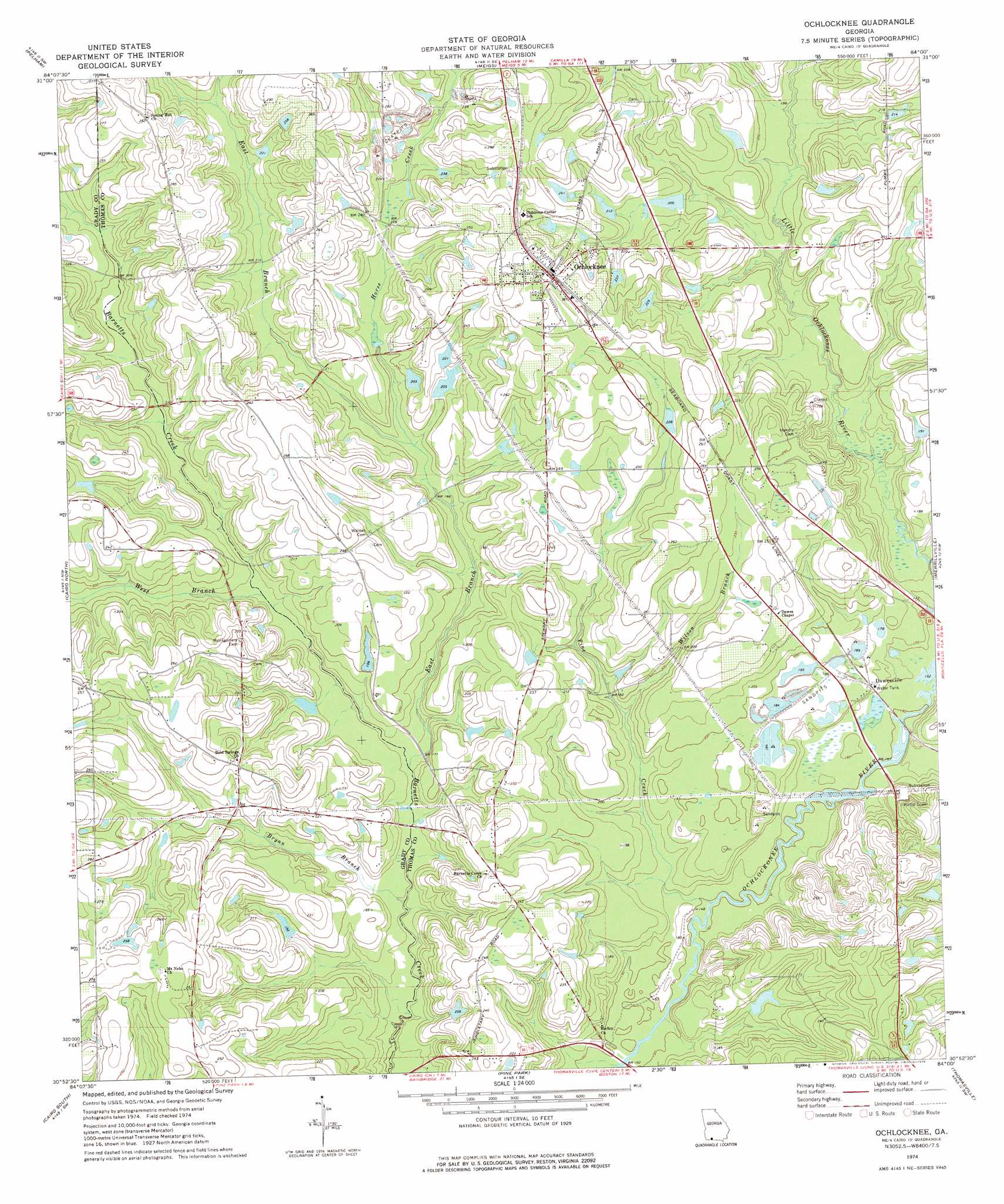
USGS Topo Quad 30084h1 - 1:24,000 scale
| Topo Map Name: | Ochlocknee |
| USGS Topo Quad ID: | 30084h1 |
| Print Size: | ca. 21 1/4" wide x 27" high |
| Southeast Coordinates: | 30.875° N latitude / 84° W longitude |
| Map Center Coordinates: | 30.9375° N latitude / 84.0625° W longitude |
| U.S. State: | GA |
| Filename: | o30084h1.jpg |
| Download Map JPG Image: | Ochlocknee topo map 1:24,000 scale |
| Map Type: | Topographic |
| Topo Series: | 7.5´ |
| Map Scale: | 1:24,000 |
| Source of Map Images: | United States Geological Survey (USGS) |
| Alternate Map Versions: |
Ochlocknee GA 1974, updated 1976 Download PDF Buy paper map Ochlocknee GA 2011 Download PDF Buy paper map Ochlocknee GA 2014 Download PDF Buy paper map |
1:24,000 Topo Quads surrounding Ochlocknee
Branchville |
Camilla |
Cotton |
Hartsfield |
Moultrie |
Gee Pond |
Pelham |
Meigs |
Chastain |
Coolidge |
Whigham |
Cairo North |
Ochlocknee |
Merrillville |
Patten |
Reno |
Cairo South |
Pine Park |
Thomasville |
Boston |
Calvary |
Beachton |
Miccosukee Ne |
Metcalf |
Monticello Ne |
> Back to 30084e1 at 1:100,000 scale
> Back to 30084a1 at 1:250,000 scale
> Back to U.S. Topo Maps home
Ochlocknee topo map: Gazetteer
Ochlocknee: Dams
Beverly Lake Dam elevation 62m 203′Singletary Lake Dam elevation 65m 213′
Singletary Lake Dam Number Three elevation 62m 203′
Singletary Lake Dam Number Two elevation 62m 203′
Ochlocknee: Populated Places
Dawesville elevation 52m 170′Ochlocknee elevation 82m 269′
Ochlocknee: Reservoirs
Beverly Lake elevation 62m 203′Singletary Lake elevation 65m 213′
Singletary Lake elevation 62m 203′
Singletary Lake Number Three elevation 62m 203′
Ochlocknee: Streams
Bryan Branch elevation 48m 157′East Branch Barnetts Creek elevation 51m 167′
Horse Creek elevation 56m 183′
Pine Creek elevation 45m 147′
West Branch Barnetts Creek elevation 53m 173′
Wilson Branch elevation 56m 183′
Ochlocknee digital topo map on disk
Buy this Ochlocknee topo map showing relief, roads, GPS coordinates and other geographical features, as a high-resolution digital map file on DVD:
Gulf Coast (LA, MS, AL, FL) & Southwestern Georgia
Buy digital topo maps: Gulf Coast (LA, MS, AL, FL) & Southwestern Georgia
 & Southwestern Georgia map DVD")