Choctaw Beach Topo Map Florida
To zoom in, hover over the map of Choctaw Beach
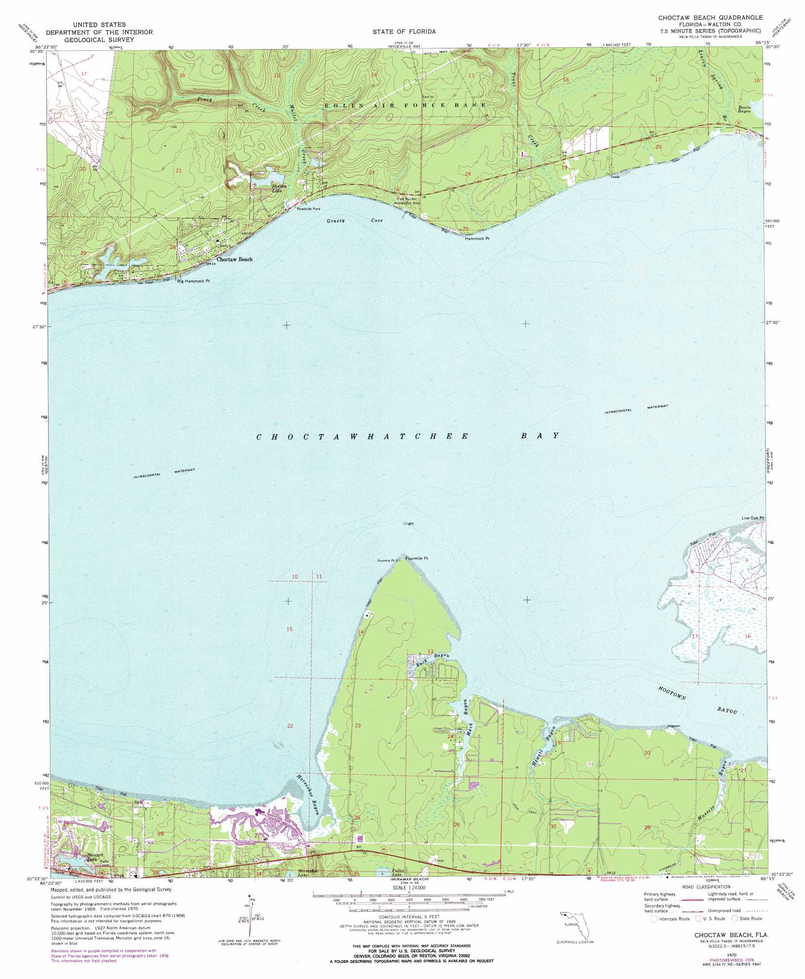
USGS Topo Quad 30086d3 - 1:24,000 scale
| Topo Map Name: | Choctaw Beach |
| USGS Topo Quad ID: | 30086d3 |
| Print Size: | ca. 21 1/4" wide x 27" high |
| Southeast Coordinates: | 30.375° N latitude / 86.25° W longitude |
| Map Center Coordinates: | 30.4375° N latitude / 86.3125° W longitude |
| U.S. State: | FL |
| Filename: | O30086D3.jpg |
| Download Map JPG Image: | Choctaw Beach topo map 1:24,000 scale |
| Map Type: | Topographic |
| Topo Series: | 7.5´ |
| Map Scale: | 1:24,000 |
| Source of Map Images: | United States Geological Survey (USGS) |
| Alternate Map Versions: |
Choctaw Beach FL 1970, updated 1972 Download PDF Buy paper map Choctaw Beach FL 1970, updated 1977 Download PDF Buy paper map Choctaw Beach FL 1994, updated 1999 Download PDF Buy paper map Choctaw Beach FL 2012 Download PDF Buy paper map Choctaw Beach FL 2015 Download PDF Buy paper map |
1:24,000 Topo Quads surrounding Choctaw Beach
Crestview South |
Spencer Flats |
Mossy Head |
De Funiak Springs West |
De Funiak Springs East |
Valparaiso |
Niceville |
Niceville Se |
Portland |
Rock Hill |
Fort Walton Beach |
Destin |
Choctaw Beach |
Freeport |
Bunker |
Miramar Beach |
Grayton Beach |
Point Washington |
||
> Back to 30086a1 at 1:100,000 scale
> Back to 30086a1 at 1:250,000 scale
> Back to U.S. Topo Maps home
Choctaw Beach topo map: Gazetteer
Choctaw Beach: Bays
Big Hammock Point elevation 5m 16′Choctawhatchee Bay elevation 0m 0′
Grassy Cove elevation 0m 0′
Horseshoe Bayou elevation 0m 0′
Choctaw Beach: Capes
Fourmile Point elevation 1m 3′Hammock Point elevation 3m 9′
Choctaw Beach: Lakes
Foster Burgess Pond elevation 2m 6′Stewart Lake elevation 0m 0′
Choctaw Beach: Parks
Fort Rucker Recreation Area elevation 3m 9′Choctaw Beach: Populated Places
Big Hammock elevation 10m 32′Choctaw Beach elevation 3m 9′
Grosh elevation 2m 6′
Sandestin elevation 2m 6′
Seascape elevation 5m 16′
The Village of Baytowne Wharf elevation 0m 0′
Turquoise Beach elevation 1m 3′
Choctaw Beach: Reservoirs
Sharon Lake elevation 1m 3′Choctaw Beach: Streams
Buck Bayou elevation 0m 0′Hewett Bayou elevation 0m 0′
Linton Spring Branch elevation 0m 0′
Mack Bayou elevation 0m 0′
Mullet Creek elevation 0m 0′
Mussett Bayou elevation 0m 0′
Piney Creek elevation 1m 3′
Trout Creek elevation 0m 0′
Choctaw Beach digital topo map on disk
Buy this Choctaw Beach topo map showing relief, roads, GPS coordinates and other geographical features, as a high-resolution digital map file on DVD:
Gulf Coast (LA, MS, AL, FL) & Southwestern Georgia
Buy digital topo maps: Gulf Coast (LA, MS, AL, FL) & Southwestern Georgia
 & Southwestern Georgia map DVD")