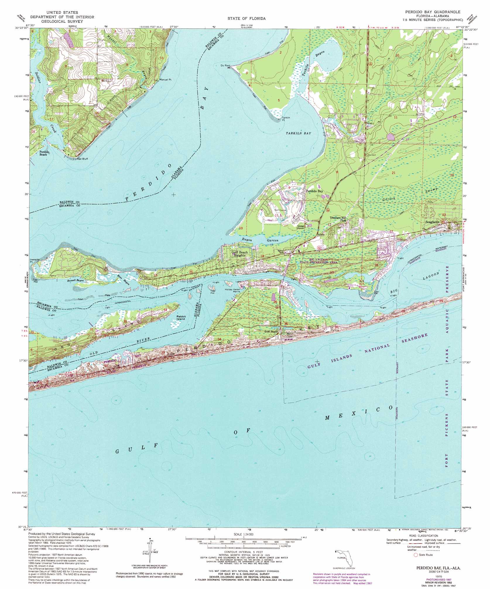
Perdido Bay Topo Map Florida
To zoom in, hover over the map of Perdido Bay
USGS Topo Quad 30087c4 - 1:24,000 scale
| Topo Map Name: | Perdido Bay |
| USGS Topo Quad ID: | 30087c4 |
| Print Size: | ca. 21 1/4" wide x 27" high |
| Southeast Coordinates: | 30.25° N latitude / 87.375° W longitude |
| Map Center Coordinates: | 30.3125° N latitude / 87.4375° W longitude |
| U.S. States: | FL, AL |
| Filename: | O30087C4.jpg |
| Download Map JPG Image: | Perdido Bay topo map 1:24,000 scale |
| Map Type: | Topographic |
| Topo Series: | 7.5´ |
| Map Scale: | 1:24,000 |
| Source of Map Images: | United States Geological Survey (USGS) |
| Alternate Map Versions: |
Perdido Bay FL 1970, updated 1971 Download PDF Buy paper map Perdido Bay FL 1970, updated 1977 Download PDF Buy paper map Perdido Bay FL 1970, updated 1988 Download PDF Buy paper map Perdido Bay FL 1970, updated 1993 Download PDF Buy paper map Perdido Bay FL 1994, updated 1994 Download PDF Buy paper map Perdido Bay FL 2012 Download PDF Buy paper map Perdido Bay FL 2015 Download PDF Buy paper map |
1:24,000 Topo Quads surrounding Perdido Bay
Robertsdale |
Elsanor |
Seminole |
Cantonment |
Pace |
Foley |
Elberta |
Lillian |
West Pensacola |
Pensacola |
Gulf Shores |
Orange Beach |
Perdido Bay |
Fort Barrancas |
Gulf Breeze |
> Back to 30087a1 at 1:100,000 scale
> Back to 30086a1 at 1:250,000 scale
> Back to U.S. Topo Maps home
Perdido Bay topo map: Gazetteer
Perdido Bay: Bays
Bayou Garcon elevation 1m 3′Bellville Bay elevation 0m 0′
Kees Bayou elevation 0m 0′
Old River elevation 0m 0′
Perdido Bay elevation 0m 0′
Russell Bayou elevation 0m 0′
Tarkiln Bay elevation 0m 0′
Tarkiln Bayou elevation 0m 0′
Perdido Bay: Bridges
Canal Bridge elevation 0m 0′Perdido Bay: Capes
Du Pont Point elevation 0m 0′Inerarity Point elevation 0m 0′
Manuel Point elevation 1m 3′
Point Ono elevation 3m 9′
Tarkiln Point elevation 0m 0′
Perdido Bay: Cliffs
Red Bluff elevation 2m 6′Perdido Bay: Guts
Old River elevation 0m 0′Perdido Bay: Islands
Ono Island elevation 1m 3′Rabbit Island elevation 0m 0′
Perdido Bay: Parks
Big Lagoon State Park elevation 1m 3′Perdido Key State Park elevation 3m 9′
Tarkiln Bayou Preserve State Park elevation 1m 3′
Perdido Bay: Populated Places
Chanticleer elevation 1m 3′Gulf Beach Heights elevation 5m 16′
Johnsons Beach elevation 0m 0′
Perdido Bay elevation 5m 16′
Perdido Key elevation 1m 3′
Seaglades elevation 5m 16′
Treasure Hill Park elevation 6m 19′
Perdido Bay: Streams
Manuel Bayou elevation 0m 0′Soldier Creek elevation 0m 0′
Perdido Bay digital topo map on disk
Buy this Perdido Bay topo map showing relief, roads, GPS coordinates and other geographical features, as a high-resolution digital map file on DVD:
Gulf Coast (LA, MS, AL, FL) & Southwestern Georgia
Buy digital topo maps: Gulf Coast (LA, MS, AL, FL) & Southwestern Georgia
 & Southwestern Georgia map DVD")