Chipola Topo Map Louisiana
To zoom in, hover over the map of Chipola
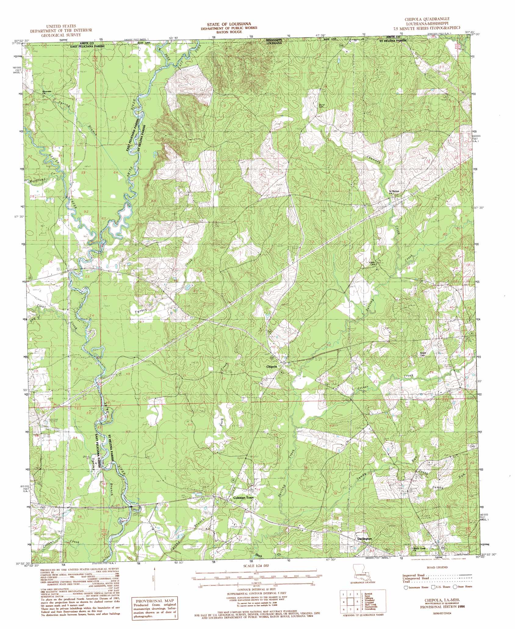
USGS Topo Quad 30090h7 - 1:24,000 scale
| Topo Map Name: | Chipola |
| USGS Topo Quad ID: | 30090h7 |
| Print Size: | ca. 21 1/4" wide x 27" high |
| Southeast Coordinates: | 30.875° N latitude / 90.75° W longitude |
| Map Center Coordinates: | 30.9375° N latitude / 90.8125° W longitude |
| U.S. States: | LA, MS |
| Filename: | o30090h7.jpg |
| Download Map JPG Image: | Chipola topo map 1:24,000 scale |
| Map Type: | Topographic |
| Topo Series: | 7.5´ |
| Map Scale: | 1:24,000 |
| Source of Map Images: | United States Geological Survey (USGS) |
| Alternate Map Versions: |
Chipola LA 1984, updated 1985 Download PDF Buy paper map Chipola LA 2012 Download PDF Buy paper map Chipola LA 2015 Download PDF Buy paper map |
1:24,000 Topo Quads surrounding Chipola
Gloster |
Bewelcome |
Liberty |
Peoria |
Lake Tangipahoa |
Centreville |
Berwick |
Street |
Gillsburg |
Terrys Creek |
Wilson |
Woodland |
Chipola |
Liverpool |
Kentwood |
Clinton |
Bluff Creek |
Hatchersville |
Greensburg |
Roseland |
Fred |
Pride |
Pine Grove |
Montpelier |
Amite |
> Back to 30090e1 at 1:100,000 scale
> Back to 30090a1 at 1:250,000 scale
> Back to U.S. Topo Maps home
Chipola topo map: Gazetteer
Chipola: Bridges
McAdam Bridge elevation 51m 167′Thompson Bridge elevation 45m 147′
Chipola: Populated Places
Chipola elevation 70m 229′Coleman Town elevation 63m 206′
Darlington elevation 79m 259′
Chipola: Streams
Beaver Creek elevation 54m 177′Beaver Creek elevation 54m 177′
Buck Creek elevation 52m 170′
Channey Creek elevation 65m 213′
Clear Creek elevation 50m 164′
Collins Creek elevation 46m 150′
Dry Branch elevation 55m 180′
East Fork Amite River elevation 56m 183′
Joiner Creek elevation 56m 183′
Little River elevation 46m 150′
Saint Marys Branch elevation 57m 187′
Saint Marys Branch elevation 57m 187′
Sandy Run elevation 53m 173′
South Sandy Run elevation 62m 203′
Spring Branch elevation 56m 183′
Spring Branch elevation 44m 144′
Turkey Creek elevation 51m 167′
West Fork Amite River elevation 56m 183′
Woodland Creek elevation 51m 167′
Chipola digital topo map on disk
Buy this Chipola topo map showing relief, roads, GPS coordinates and other geographical features, as a high-resolution digital map file on DVD: