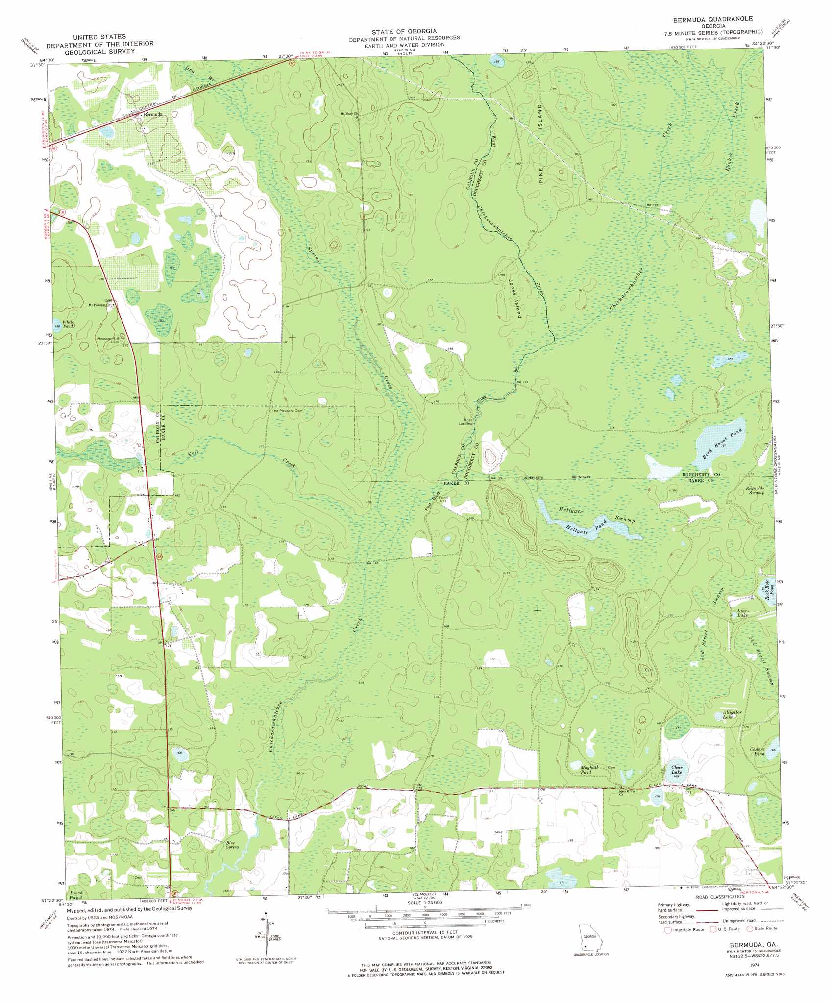
Bermuda Topo Map Georgia
To zoom in, hover over the map of Bermuda
USGS Topo Quad 31084d4 - 1:24,000 scale
| Topo Map Name: | Bermuda |
| USGS Topo Quad ID: | 31084d4 |
| Print Size: | ca. 21 1/4" wide x 27" high |
| Southeast Coordinates: | 31.375° N latitude / 84.375° W longitude |
| Map Center Coordinates: | 31.4375° N latitude / 84.4375° W longitude |
| U.S. State: | GA |
| Filename: | o31084d4.jpg |
| Download Map JPG Image: | Bermuda topo map 1:24,000 scale |
| Map Type: | Topographic |
| Topo Series: | 7.5´ |
| Map Scale: | 1:24,000 |
| Source of Map Images: | United States Geological Survey (USGS) |
| Alternate Map Versions: |
Bermuda GA 1974, updated 1976 Download PDF Buy paper map Bermuda GA 2011 Download PDF Buy paper map Bermuda GA 2014 Download PDF Buy paper map |
1:24,000 Topo Quads surrounding Bermuda
Martins Crossroads |
Doverel |
Chickasawhatchee |
Sasser |
Leesburg |
Edison |
Morgan |
Holt |
Pretoria |
Albany West |
Arlington |
Leary |
Bermuda |
Red Store Crossroads |
Baconton North |
Damascus |
Bethany |
Elmodel |
Newton |
Baconton South |
Colquitt |
Cooktown |
Hopeful |
Branchville |
Camilla |
> Back to 31084a1 at 1:100,000 scale
> Back to 31084a1 at 1:250,000 scale
> Back to U.S. Topo Maps home
Bermuda topo map: Gazetteer
Bermuda: Cliffs
Red Bluff elevation 52m 170′Bermuda: Islands
Jones Island elevation 55m 180′Pine Island elevation 55m 180′
Bermuda: Lakes
Alligator Lake elevation 52m 170′Bird Roost Pond elevation 53m 173′
Clear Lake elevation 51m 167′
Hellgate Pond elevation 50m 164′
Liar Lake elevation 54m 177′
Mayhall Pond elevation 55m 180′
Rock Hole Pond elevation 52m 170′
White Pond elevation 60m 196′
Bermuda: Populated Places
Bermuda elevation 58m 190′Bermuda: Springs
Blue Spring elevation 48m 157′Bermuda: Streams
Dry Branch elevation 54m 177′Keel Creek elevation 50m 164′
Kiokee Creek elevation 53m 173′
Spring Creek elevation 50m 164′
West Chickasawhatchee Creek elevation 53m 173′
Bermuda: Swamps
Fortysecond Street Swamp elevation 52m 170′Hellgate Swamp elevation 52m 170′
Twentythird Street Swamp elevation 52m 170′
Bermuda digital topo map on disk
Buy this Bermuda topo map showing relief, roads, GPS coordinates and other geographical features, as a high-resolution digital map file on DVD:
Gulf Coast (LA, MS, AL, FL) & Southwestern Georgia
Buy digital topo maps: Gulf Coast (LA, MS, AL, FL) & Southwestern Georgia
 & Southwestern Georgia map DVD")