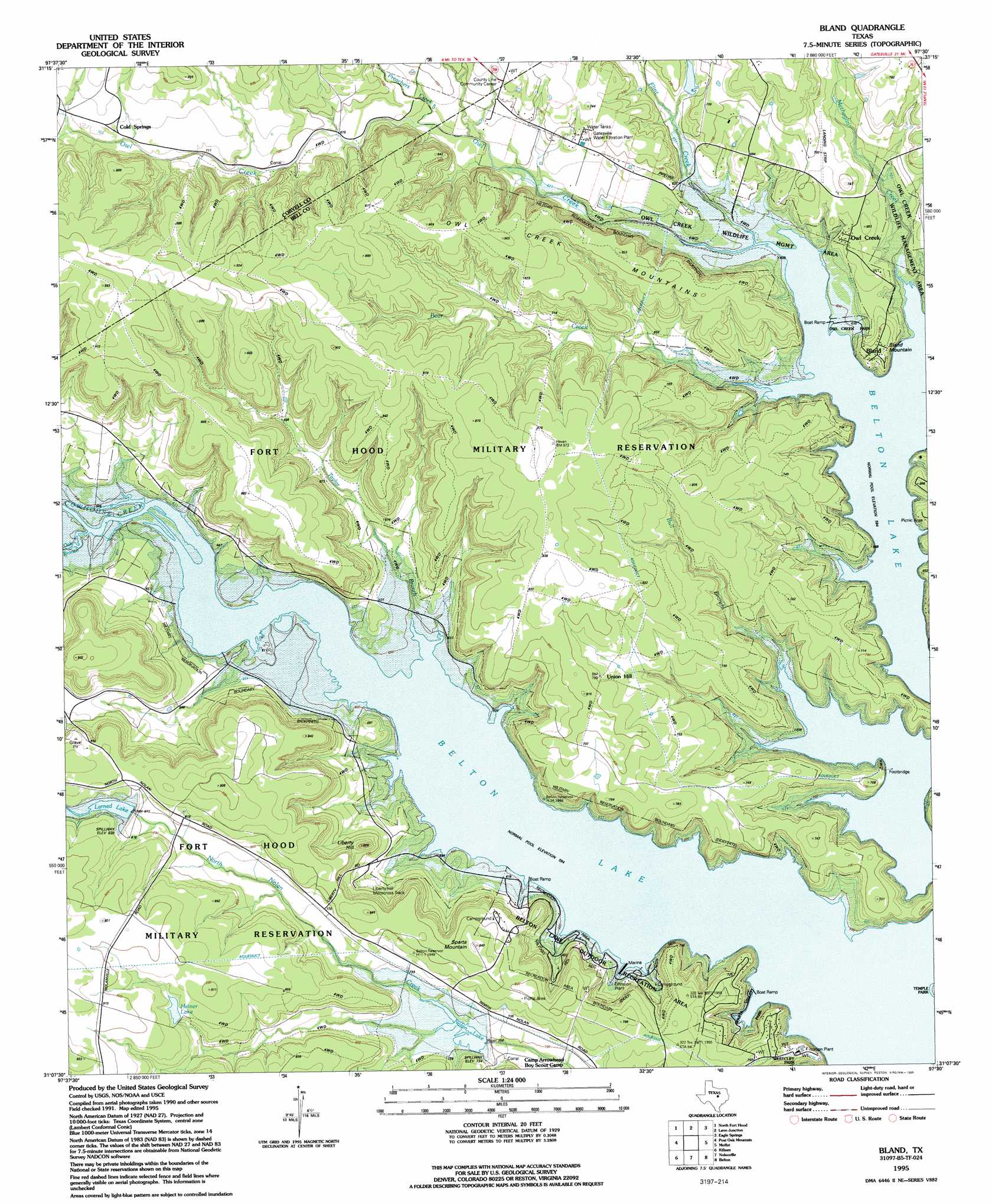
Bland Topo Map Texas
To zoom in, hover over the map of Bland
USGS Topo Quad 31097b5 - 1:24,000 scale
| Topo Map Name: | Bland |
| USGS Topo Quad ID: | 31097b5 |
| Print Size: | ca. 21 1/4" wide x 27" high |
| Southeast Coordinates: | 31.125° N latitude / 97.5° W longitude |
| Map Center Coordinates: | 31.1875° N latitude / 97.5625° W longitude |
| U.S. State: | TX |
| Filename: | o31097b5.jpg |
| Download Map JPG Image: | Bland topo map 1:24,000 scale |
| Map Type: | Topographic |
| Topo Series: | 7.5´ |
| Map Scale: | 1:24,000 |
| Source of Map Images: | United States Geological Survey (USGS) |
| Alternate Map Versions: |
Bland TX 1947, updated 1953 Download PDF Buy paper map Bland TX 1958, updated 1961 Download PDF Buy paper map Bland TX 1958, updated 1974 Download PDF Buy paper map Bland TX 1958, updated 1979 Download PDF Buy paper map Bland TX 1995, updated 1995 Download PDF Buy paper map Bland TX 2010 Download PDF Buy paper map Bland TX 2012 Download PDF Buy paper map Bland TX 2016 Download PDF Buy paper map |
1:24,000 Topo Quads surrounding Bland
Gatesville West |
Gatesville East |
Oglesby |
Mcgregor |
South Bosque |
Shell Mountains |
North Fort Hood |
Leon Junction |
Eagle Springs |
Moody |
Fort Hood |
Post Oak Mountain |
Bland |
Moffat |
Troy |
Mcmillan Mountains |
Killeen |
Nolanville |
Belton |
Temple |
Ding Dong |
Youngsport |
Salado |
Holland |
Little River |
> Back to 31097a1 at 1:100,000 scale
> Back to 31096a1 at 1:250,000 scale
> Back to U.S. Topo Maps home
Bland topo map: Gazetteer
Bland: Airports
The Grove Ranch Airport elevation 239m 784′Woody McClellan Ranch Airport elevation 211m 692′
Bland: Dams
Flint Trib Lake Dam elevation 195m 639′Heiner Lake Dam elevation 258m 846′
Soil Conservation Service Site 2 Dam elevation 247m 810′
Soil Conservation Service Site 3 Dam elevation 207m 679′
Bland: Parks
Fort Hood Recreation Area elevation 183m 600′Liberty Hill Motocross Track elevation 204m 669′
Owl Creek Park elevation 183m 600′
Owl Creek Wildlife Management Area elevation 187m 613′
Sparta Valley Park elevation 186m 610′
Bland: Populated Places
Bland elevation 181m 593′Cold Springs elevation 223m 731′
Owl Creek elevation 201m 659′
Union Hill elevation 238m 780′
Bland: Reservoirs
Flint Trib Lake elevation 195m 639′Heiner Lake elevation 257m 843′
Larned Lake elevation 255m 836′
Nolan Lake elevation 220m 721′
Soil Conservation Service Site 2 Reservoir elevation 247m 810′
Soil Conservation Service Site 3 Reservoir elevation 207m 679′
Bland: Streams
Bear Creek elevation 181m 593′Bull Branch elevation 181m 593′
Cowhouse Creek elevation 181m 593′
Flint Creek elevation 181m 593′
Oak Branch elevation 181m 593′
Owl Creek elevation 181m 593′
Preachers Creek elevation 198m 649′
Taylor Branch elevation 181m 593′
Bland: Summits
Bland Mountain elevation 215m 705′Liberty Hill elevation 233m 764′
Owl Creek Mountains elevation 263m 862′
Sparta Mountain elevation 256m 839′
Bland digital topo map on disk
Buy this Bland topo map showing relief, roads, GPS coordinates and other geographical features, as a high-resolution digital map file on DVD: