Fort Bliss Se Topo Map Texas
To zoom in, hover over the map of Fort Bliss Se
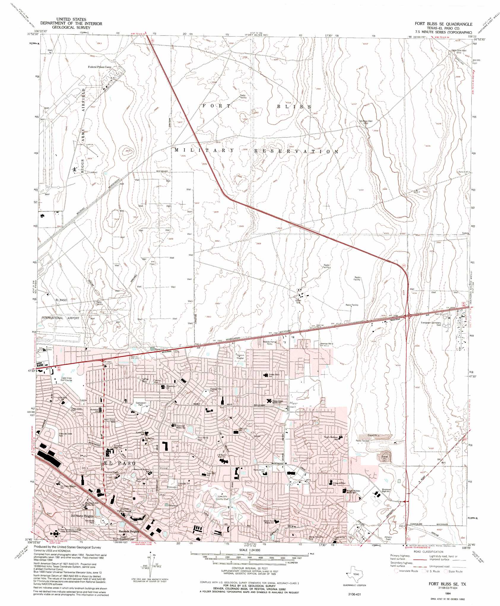
USGS Topo Quad 31106g3 - 1:24,000 scale
| Topo Map Name: | Fort Bliss Se |
| USGS Topo Quad ID: | 31106g3 |
| Print Size: | ca. 21 1/4" wide x 27" high |
| Southeast Coordinates: | 31.75° N latitude / 106.25° W longitude |
| Map Center Coordinates: | 31.8125° N latitude / 106.3125° W longitude |
| U.S. State: | TX |
| Filename: | o31106g3.jpg |
| Download Map JPG Image: | Fort Bliss Se topo map 1:24,000 scale |
| Map Type: | Topographic |
| Topo Series: | 7.5´ |
| Map Scale: | 1:24,000 |
| Source of Map Images: | United States Geological Survey (USGS) |
| Alternate Map Versions: |
Fort Bliss SE TX 1948 Download PDF Buy paper map Fort Bliss SE TX 1955, updated 1959 Download PDF Buy paper map Fort Bliss SE TX 1955, updated 1968 Download PDF Buy paper map Fort Bliss SE TX 1955, updated 1974 Download PDF Buy paper map Fort Bliss SE TX 1994, updated 1994 Download PDF Buy paper map Fort Bliss SE TX 2010 Download PDF Buy paper map Fort Bliss SE TX 2012 Download PDF Buy paper map Fort Bliss SE TX 2016 Download PDF Buy paper map |
1:24,000 Topo Quads surrounding Fort Bliss Se
Anthony |
Newman Sw |
Newman |
Desert Sw |
Desert Se |
Canutillo |
North Franklin Mountain |
Fort Bliss Ne |
Nations East Well |
Hueco Tanks |
Smeltertown |
El Paso |
Fort Bliss Se |
Nations South Well |
Helms West Well |
Ysleta Nw |
Ysleta |
Clint Nw |
Clint Ne |
|
San Elizario |
Clint |
Clint Se |
> Back to 31106e1 at 1:100,000 scale
> Back to 31106a1 at 1:250,000 scale
> Back to U.S. Topo Maps home
Fort Bliss Se topo map: Gazetteer
Fort Bliss Se: Parks
Champions Sports Plex elevation 1221m 4005′Cielo Vista Park elevation 1206m 3956′
Cinema Park elevation 1210m 3969′
Eastwood Junior High School Baseball Field elevation 1203m 3946′
Eastwood Junior High School Track and Field elevation 1203m 3946′
Eastwood Park elevation 1206m 3956′
El Paso Community College Baseball Stadium elevation 1136m 3727′
Excalibur Stadium at Hanks High School elevation 1208m 3963′
Hacienda Park elevation 1161m 3809′
Palm Grove Park elevation 1206m 3956′
Pebble Hills Park elevation 1209m 3966′
Pico Norte Park elevation 1203m 3946′
Suffolk Park elevation 1203m 3946′
Travis White Park elevation 1196m 3923′
Tyrone Park elevation 1205m 3953′
Vista del Sol Park elevation 1210m 3969′
Vista del Valle Park elevation 1204m 3950′
Fort Bliss Se: Populated Places
Del Norte Heights elevation 1154m 3786′Las Palmas Colonia elevation 1225m 4019′
Las Palmas Number 2 Colonia elevation 1225m 4019′
Turf Estates Number 1 Colonia elevation 1220m 4002′
Fort Bliss Se: Wells
Bakers Well elevation 1205m 3953′Hells Hole Well elevation 1220m 4002′
McElroy Well elevation 1220m 4002′
Fort Bliss Se digital topo map on disk
Buy this Fort Bliss Se topo map showing relief, roads, GPS coordinates and other geographical features, as a high-resolution digital map file on DVD: