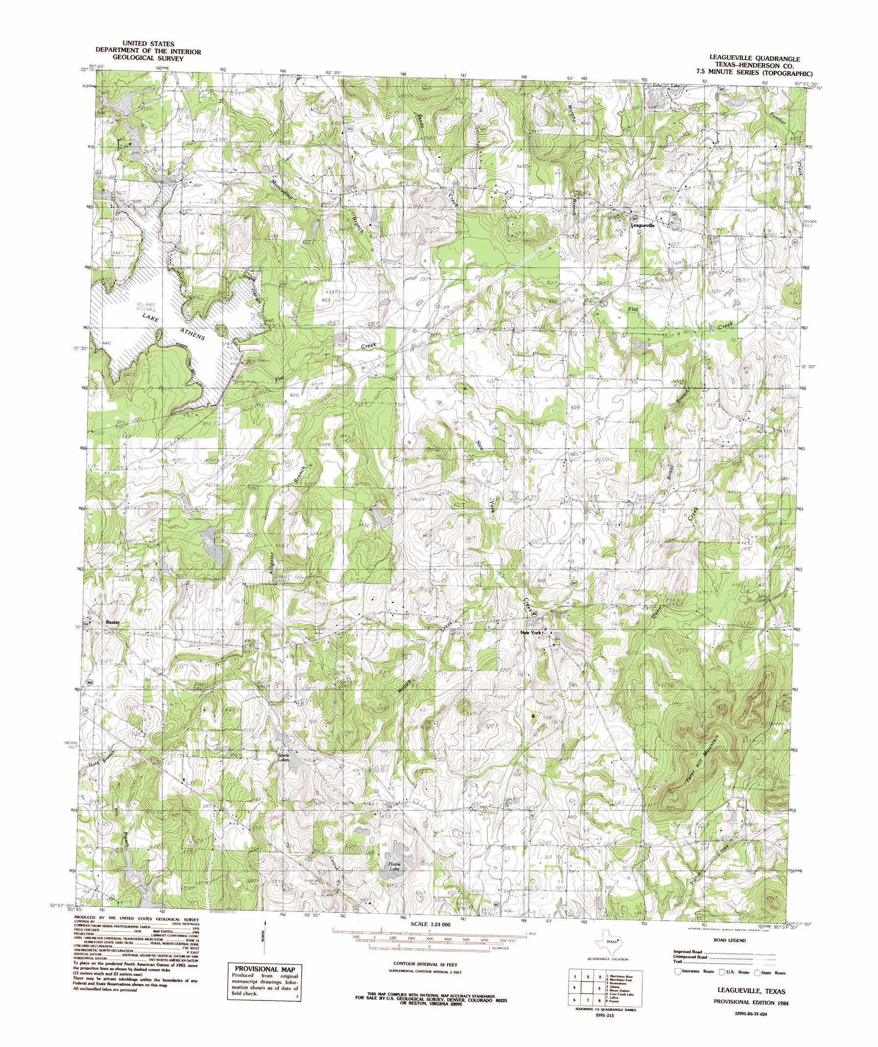
Leagueville Topo Map Texas
To zoom in, hover over the map of Leagueville
USGS Topo Quad 32095b6 - 1:24,000 scale
| Topo Map Name: | Leagueville |
| USGS Topo Quad ID: | 32095b6 |
| Print Size: | ca. 21 1/4" wide x 27" high |
| Southeast Coordinates: | 32.125° N latitude / 95.625° W longitude |
| Map Center Coordinates: | 32.1875° N latitude / 95.6875° W longitude |
| U.S. State: | TX |
| Filename: | o32095b6.jpg |
| Download Map JPG Image: | Leagueville topo map 1:24,000 scale |
| Map Type: | Topographic |
| Topo Series: | 7.5´ |
| Map Scale: | 1:24,000 |
| Source of Map Images: | United States Geological Survey (USGS) |
| Alternate Map Versions: |
Leagueville TX 1984, updated 1984 Download PDF Buy paper map Leagueville TX 2010 Download PDF Buy paper map Leagueville TX 2013 Download PDF Buy paper map Leagueville TX 2016 Download PDF Buy paper map |
1:24,000 Topo Quads surrounding Leagueville
Phalba |
Martins Mill |
Ben Wheeler |
Carroll |
Mount Sylvan |
Stockard |
Murchinson West |
Murchinson East |
Brownsboro |
Chandler |
Mallard Hill |
Athens |
Leagueville |
Moore Station |
Saline Bay |
Cross Roads |
Coon Creek Lake |
La Rue |
Poynor |
Berryville |
Cayuga |
Blackfoot |
Wilkerson Mountain |
Pert |
Todd City |
> Back to 32095a1 at 1:100,000 scale
> Back to 32094a1 at 1:250,000 scale
> Back to U.S. Topo Maps home
Leagueville topo map: Gazetteer
Leagueville: Dams
Dogwood Acres Lake Dam elevation 122m 400′Echo Lake Dam elevation 124m 406′
Lake Athens Dam elevation 121m 396′
Tindel Lake Dam elevation 145m 475′
Leagueville: Lakes
Farmer Lake elevation 136m 446′Harris Lake elevation 113m 370′
Hume Lake elevation 145m 475′
Jones Lake elevation 140m 459′
Lock Lake elevation 145m 475′
Steele Lakes elevation 139m 456′
Leagueville: Populated Places
Baxter elevation 152m 498′Leagueville elevation 128m 419′
New York elevation 152m 498′
Leagueville: Reservoirs
Athens Lake elevation 134m 439′Dogwood Acres Lake elevation 122m 400′
Echo Lake elevation 124m 406′
Tindel Lake elevation 145m 475′
Leagueville: Streams
Adams Creek elevation 115m 377′Alligator Branch elevation 121m 396′
Bear Creek elevation 134m 439′
Boggy Branch elevation 111m 364′
Fame Branch elevation 119m 390′
Maggie Creek elevation 127m 416′
Murphy Branch elevation 113m 370′
Muscadine Branch elevation 115m 377′
New York Creek elevation 116m 380′
Sandy Creek elevation 113m 370′
Leagueville: Summits
Tater Hill Mountain elevation 234m 767′Leagueville digital topo map on disk
Buy this Leagueville topo map showing relief, roads, GPS coordinates and other geographical features, as a high-resolution digital map file on DVD: