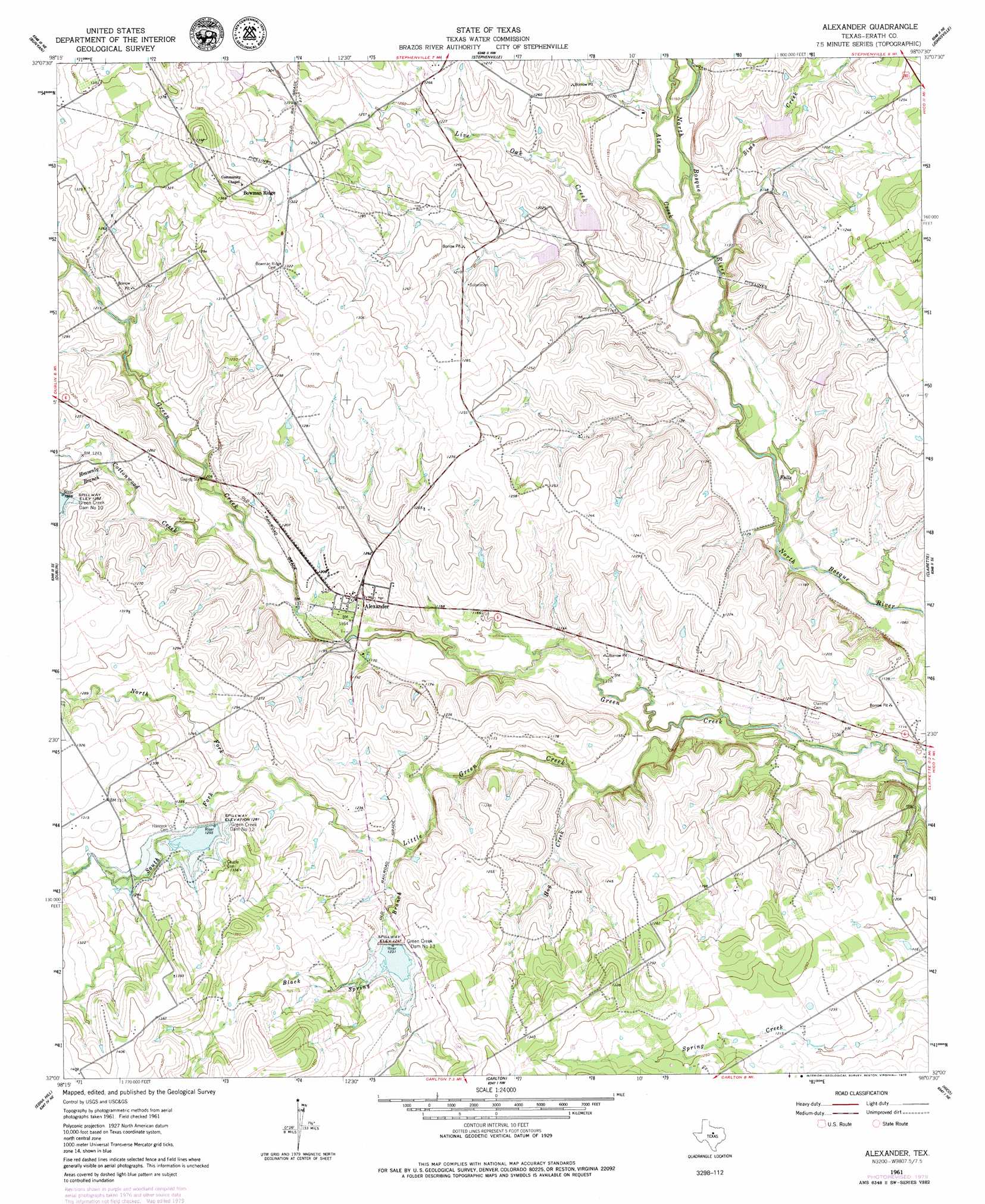
Alexander Topo Map Texas
To zoom in, hover over the map of Alexander
USGS Topo Quad 32098a2 - 1:24,000 scale
| Topo Map Name: | Alexander |
| USGS Topo Quad ID: | 32098a2 |
| Print Size: | ca. 21 1/4" wide x 27" high |
| Southeast Coordinates: | 32° N latitude / 98.125° W longitude |
| Map Center Coordinates: | 32.0625° N latitude / 98.1875° W longitude |
| U.S. State: | TX |
| Filename: | o32098a2.jpg |
| Download Map JPG Image: | Alexander topo map 1:24,000 scale |
| Map Type: | Topographic |
| Topo Series: | 7.5´ |
| Map Scale: | 1:24,000 |
| Source of Map Images: | United States Geological Survey (USGS) |
| Alternate Map Versions: |
Alexander TX 1961, updated 1962 Download PDF Buy paper map Alexander TX 2010 Download PDF Buy paper map Alexander TX 2012 Download PDF Buy paper map Alexander TX 2016 Download PDF Buy paper map |
1:24,000 Topo Quads surrounding Alexander
Huckabay Sw |
Huckabay |
Knob Hill |
Bluff Dale |
Paluxy |
Lingleville |
Bunyan |
Stephenville |
Johnsville |
Chalk Mountain |
Comyn |
Dublin |
Alexander |
Clairette |
Camp Branch |
Proctor |
Edna Hill |
Carlton |
Hico |
Spring Creek Gap |
Gustine |
Lamkin |
Gentrys Mill |
Eidson Lake |
Fairy |
> Back to 32098a1 at 1:100,000 scale
> Back to 32098a1 at 1:250,000 scale
> Back to U.S. Topo Maps home
Alexander topo map: Gazetteer
Alexander: Airports
J F Ranch Airport elevation 370m 1213′Alexander: Dams
Farrow Lake Dam elevation 398m 1305′Green Creek Dam Number 10 elevation 388m 1272′
Green Creek Dam Number 12 elevation 392m 1286′
Green Creek Dam Number 13 elevation 381m 1250′
Soil Conservation Service Site 12 Dam elevation 380m 1246′
Soil Conservation Service Site 13 Dam elevation 371m 1217′
Soil Conservation Service Site 19 Dam elevation 360m 1181′
Soil Conservation Service Site 20 Dam elevation 350m 1148′
Soil Conservation Service Site 21 Dam elevation 356m 1167′
Soil Conservation Service Site 22 Dam elevation 339m 1112′
Soil Conservation Service Site 23 Dam elevation 350m 1148′
Alexander: Populated Places
Alexander elevation 366m 1200′Alexander: Reservoirs
Farrow Lake elevation 398m 1305′Soil Conservation Service Site 12 Reservoir elevation 380m 1246′
Soil Conservation Service Site 13 Reservoir elevation 371m 1217′
Soil Conservation Service Site 19 Reservoir elevation 360m 1181′
Soil Conservation Service Site 20 Reservoir elevation 350m 1148′
Soil Conservation Service Site 21 Reservoir elevation 356m 1167′
Soil Conservation Service Site 22 Reservoir elevation 339m 1112′
Soil Conservation Service Site 23 Reservoir elevation 350m 1148′
Alexander: Streams
Alarm Creek elevation 336m 1102′Black Spring Branch elevation 359m 1177′
Cottonwood Creek elevation 356m 1167′
Heavenly Branch elevation 372m 1220′
Hog Creek elevation 345m 1131′
Little Green Creek elevation 337m 1105′
Live Oak Creek elevation 342m 1122′
North Fork Little Green Creek elevation 373m 1223′
Sims Creek elevation 345m 1131′
South Fork Little Green Creek elevation 373m 1223′
Alexander digital topo map on disk
Buy this Alexander topo map showing relief, roads, GPS coordinates and other geographical features, as a high-resolution digital map file on DVD: