Stephenville Topo Map Texas
To zoom in, hover over the map of Stephenville
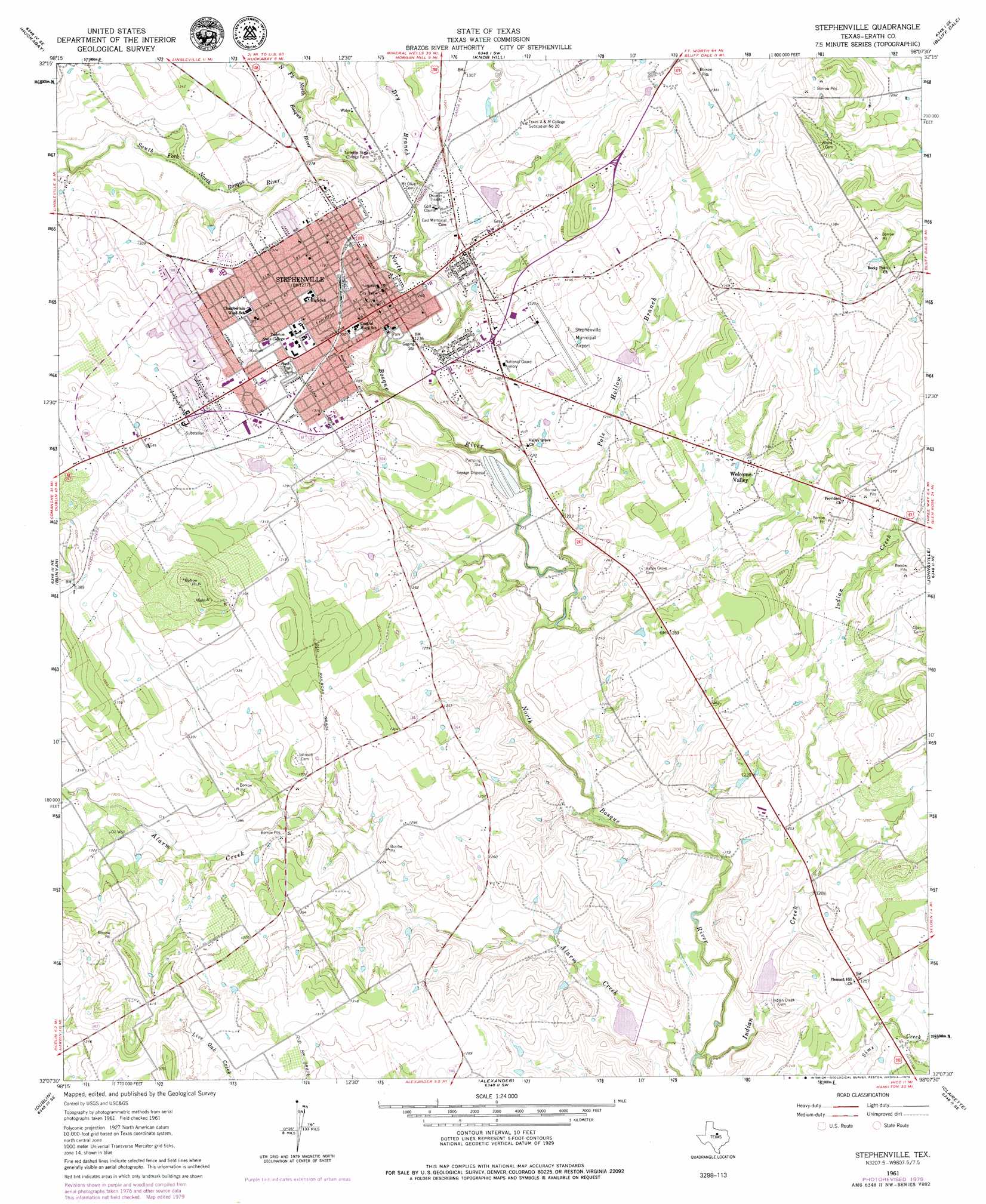
USGS Topo Quad 32098b2 - 1:24,000 scale
| Topo Map Name: | Stephenville |
| USGS Topo Quad ID: | 32098b2 |
| Print Size: | ca. 21 1/4" wide x 27" high |
| Southeast Coordinates: | 32.125° N latitude / 98.125° W longitude |
| Map Center Coordinates: | 32.1875° N latitude / 98.1875° W longitude |
| U.S. State: | TX |
| Filename: | o32098b2.jpg |
| Download Map JPG Image: | Stephenville topo map 1:24,000 scale |
| Map Type: | Topographic |
| Topo Series: | 7.5´ |
| Map Scale: | 1:24,000 |
| Source of Map Images: | United States Geological Survey (USGS) |
| Alternate Map Versions: |
Stephenville TX 1961, updated 1963 Download PDF Buy paper map Stephenville TX 1961, updated 1976 Download PDF Buy paper map Stephenville TX 1961, updated 1979 Download PDF Buy paper map Stephenville TX 1961, updated 1979 Download PDF Buy paper map Stephenville TX 2010 Download PDF Buy paper map Stephenville TX 2012 Download PDF Buy paper map Stephenville TX 2016 Download PDF Buy paper map |
1:24,000 Topo Quads surrounding Stephenville
Reddy Mountain |
Turkey Creek |
Morgan Mill |
Bluff Dale Ne |
Tolar |
Huckabay Sw |
Huckabay |
Knob Hill |
Bluff Dale |
Paluxy |
Lingleville |
Bunyan |
Stephenville |
Johnsville |
Chalk Mountain |
Comyn |
Dublin |
Alexander |
Clairette |
Camp Branch |
Proctor |
Edna Hill |
Carlton |
Hico |
Spring Creek Gap |
> Back to 32098a1 at 1:100,000 scale
> Back to 32098a1 at 1:250,000 scale
> Back to U.S. Topo Maps home
Stephenville topo map: Gazetteer
Stephenville: Airports
Clark Field Municipal Airport elevation 399m 1309′Stephenville: Dams
Kyle Dam elevation 371m 1217′Pittman Lake Dam elevation 391m 1282′
Soil Conservation Service Site 15 Dam elevation 381m 1250′
Soil Conservation Service Site 17 Dam elevation 355m 1164′
Soil Conservation Service Site 18 Dam elevation 359m 1177′
Soil Conservation Service Site 7 Dam elevation 388m 1272′
Stephenville: Parks
Memorial Stadium elevation 416m 1364′Stephenville City Park elevation 378m 1240′
Stephenville: Populated Places
Stephenville elevation 388m 1272′Welcome Valley elevation 399m 1309′
Stephenville: Reservoirs
Kyle Lake elevation 371m 1217′Pittman Lake elevation 391m 1282′
Soil Conservation Service Site 15 Reservoir elevation 381m 1250′
Soil Conservation Service Site 17 Reservoir elevation 355m 1164′
Soil Conservation Service Site 18 Reservoir elevation 359m 1177′
Soil Conservation Service Site 7 Reservoir elevation 388m 1272′
Stephenville: Streams
Dry Branch elevation 377m 1236′Indian Creek elevation 351m 1151′
North Fork North Bosque River elevation 381m 1250′
Pole Hollow Branch elevation 364m 1194′
South Fork North Bosque River elevation 381m 1250′
Stephenville digital topo map on disk
Buy this Stephenville topo map showing relief, roads, GPS coordinates and other geographical features, as a high-resolution digital map file on DVD: