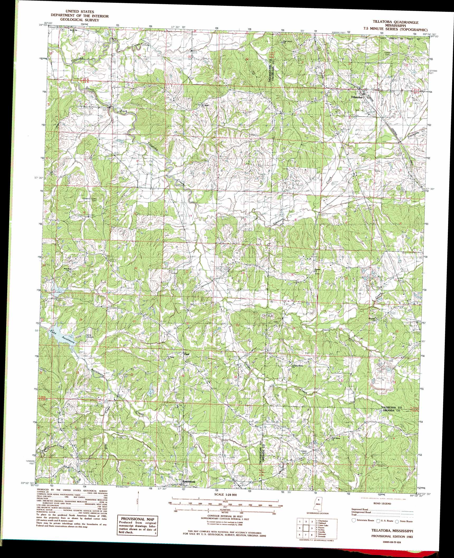
Tillatoba Topo Map Mississippi
To zoom in, hover over the map of Tillatoba
USGS Topo Quad 33089h8 - 1:24,000 scale
| Topo Map Name: | Tillatoba |
| USGS Topo Quad ID: | 33089h8 |
| Print Size: | ca. 21 1/4" wide x 27" high |
| Southeast Coordinates: | 33.875° N latitude / 89.875° W longitude |
| Map Center Coordinates: | 33.9375° N latitude / 89.9375° W longitude |
| U.S. State: | MS |
| Filename: | o33089h8.jpg |
| Download Map JPG Image: | Tillatoba topo map 1:24,000 scale |
| Map Type: | Topographic |
| Topo Series: | 7.5´ |
| Map Scale: | 1:24,000 |
| Source of Map Images: | United States Geological Survey (USGS) |
| Alternate Map Versions: |
Tillatoba MS 1983, updated 1983 Download PDF Buy paper map Tillatoba MS 2000, updated 2003 Download PDF Buy paper map Tillatoba MS 2012 Download PDF Buy paper map Tillatoba MS 2015 Download PDF Buy paper map |
| FStopo: | US Forest Service topo Tillatoba is available: Download FStopo PDF Download FStopo TIF |
1:24,000 Topo Quads surrounding Tillatoba
Crowder |
Tocowa |
Courtland |
Shuford |
Water Valley West |
Fishhook Lake |
Charleston |
Oakland |
Coker Lake |
Velma |
Tippo |
Paynes |
Tillatoba |
Scobey |
Coffeeville |
Philipp |
Cascilla |
Holcomb |
Grenada |
Kincaid |
Money |
Avalon |
Jefferson |
Tie Plant |
Duck Hill |
> Back to 33089e1 at 1:100,000 scale
> Back to 33088a1 at 1:250,000 scale
> Back to U.S. Topo Maps home
Tillatoba topo map: Gazetteer
Tillatoba: Dams
Ascalmore Creek Structure Y-17a-1 Dam elevation 71m 232′Ascalmore Creek Structure Y-17a-9 Dam elevation 73m 239′
Ascalmore Creek Structure Yo-30-22 Dam elevation 109m 357′
Ascalmore Creek Structure Yo-30-6 Dam elevation 95m 311′
Ascalmore Creek Structure Yo-30-7 Dam elevation 91m 298′
Ascalmore Creek Structure Yo-30-8 Dam elevation 110m 360′
Burns Lake Dam elevation 61m 200′
Goodman Sewage Lagoon Dam elevation 80m 262′
Tillatoba: Populated Places
Murphreesboro (historical) elevation 79m 259′Paul elevation 117m 383′
Rosebloom elevation 116m 380′
Tillatoba elevation 94m 308′
Tillatoba: Post Offices
Black Oak Post Office (historical) elevation 100m 328′Tillatoba: Reservoirs
Lake Ascalmore elevation 77m 252′Tillatoba: Streams
Davis Creek elevation 76m 249′Dry Creek elevation 77m 252′
Harper Creek elevation 76m 249′
Simmons Creek elevation 69m 226′
South Fork Tillatoba Creek elevation 61m 200′
Tillatoba Creek elevation 61m 200′
Tillatoba digital topo map on disk
Buy this Tillatoba topo map showing relief, roads, GPS coordinates and other geographical features, as a high-resolution digital map file on DVD: