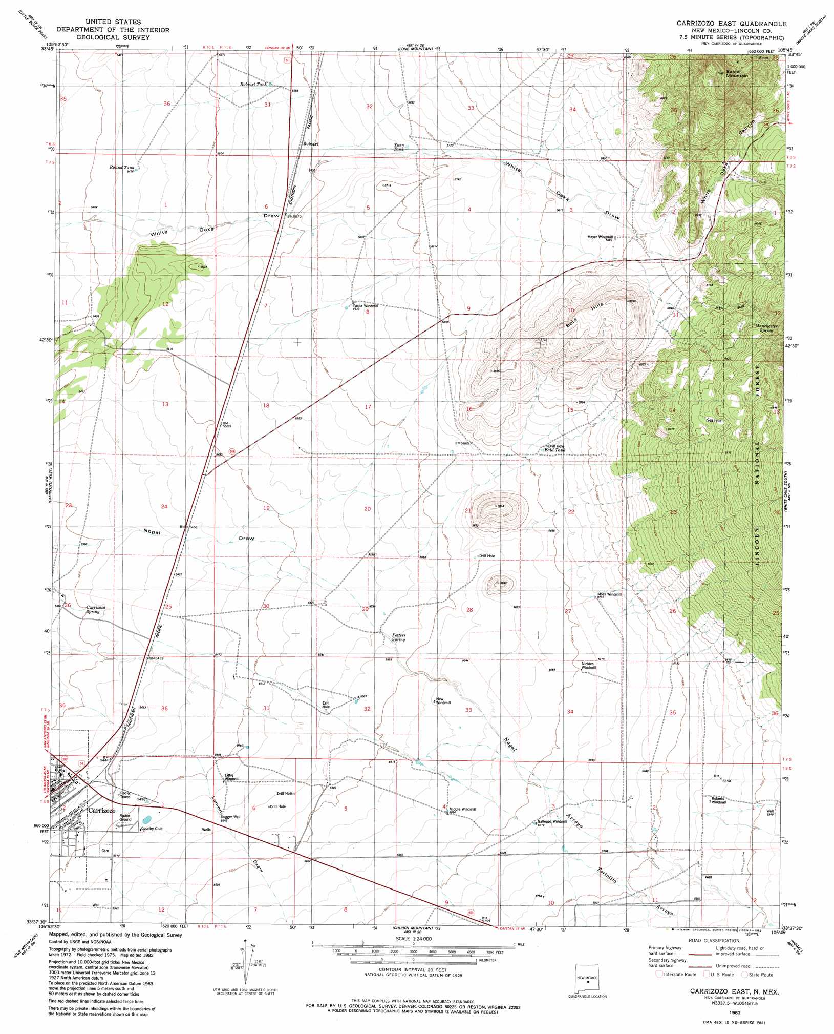
Carrizoza East Topo Map New Mexico
To zoom in, hover over the map of Carrizoza East
USGS Topo Quad 33105f7 - 1:24,000 scale
| Topo Map Name: | Carrizoza East |
| USGS Topo Quad ID: | 33105f7 |
| Print Size: | ca. 21 1/4" wide x 27" high |
| Southeast Coordinates: | 33.625° N latitude / 105.75° W longitude |
| Map Center Coordinates: | 33.6875° N latitude / 105.8125° W longitude |
| U.S. State: | NM |
| Filename: | o33105f7.jpg |
| Download Map JPG Image: | Carrizoza East topo map 1:24,000 scale |
| Map Type: | Topographic |
| Topo Series: | 7.5´ |
| Map Scale: | 1:24,000 |
| Source of Map Images: | United States Geological Survey (USGS) |
| Alternate Map Versions: |
Carrizozo East NM 1982, updated 1982 Download PDF Buy paper map Carrizozo East NM 2011 Download PDF Buy paper map Carrizozo East NM 2013 Download PDF Buy paper map |
| FStopo: | US Forest Service topo Carrizozo East is available: Download FStopo PDF Download FStopo TIF |
1:24,000 Topo Quads surrounding Carrizoza East
Lovelace Mesa |
Dulce Draw |
Little Black Peak Ne |
Ancho |
Chupadero Mountain |
Broken Back Crater |
Little Black Peak |
Lone Mountain |
White Oaks North |
Jicarilla Peak |
Wagon Canyon |
Carrizoza West |
Carrizoza East |
White Oaks South |
Jacob Spring |
Bull Gap |
Cub Mountain |
Church Mountain |
Nogal |
Capitan |
Oscura |
Godfrey Peak |
Nogal Peak |
Angus |
Fort Stanton |
> Back to 33105e1 at 1:100,000 scale
> Back to 33104a1 at 1:250,000 scale
> Back to U.S. Topo Maps home
Carrizoza East topo map: Gazetteer
Carrizoza East: Arroyos
Nogal Arroyo elevation 1687m 5534′Carrizoza East: Mines
Annie Cade Mine elevation 2027m 6650′Carrizozo Plant elevation 1681m 5515′
Collier Mine elevation 2027m 6650′
Cristopher elevation 1903m 6243′
Forgotten elevation 1973m 6473′
Gregory Mine elevation 2027m 6650′
Homestake South elevation 2081m 6827′
Lovelace Plant elevation 1683m 5521′
Luckless elevation 2064m 6771′
Omega Mine elevation 2027m 6650′
Southwest Mineral Corp Mill elevation 1662m 5452′
Carrizoza East: Populated Places
Manchester (historical) elevation 2007m 6584′Robsart elevation 1705m 5593′
Carrizoza East: Post Offices
Manchester Post Office (historical) elevation 2007m 6584′Carrizoza East: Ranges
Bald Hills elevation 1896m 6220′Carrizoza East: Reservoirs
Bald Tank elevation 1744m 5721′Little Windmill elevation 1682m 5518′
Mayer Windmill elevation 1794m 5885′
Middle Windmill elevation 1727m 5666′
Moss Windmill elevation 1748m 5734′
New Windmill elevation 1720m 5643′
Nickles Windmill elevation 1739m 5705′
Robsart Tank elevation 1695m 5561′
Round Tank elevation 1657m 5436′
Twin Tank elevation 1727m 5666′
Yucca Windmill elevation 1716m 5629′
Carrizoza East: Springs
Carrizozo Spring elevation 1646m 5400′Carrizozo Spring elevation 1652m 5419′
Fetters Spring elevation 1695m 5561′
Manchester Spring elevation 2007m 6584′
Carrizoza East: Streams
Nogal Creek elevation 1799m 5902′Carrizoza East: Summits
Baxter Mountain elevation 2207m 7240′Carrizoza East: Valleys
Lemon Draw elevation 1671m 5482′White Oaks Canyon elevation 1804m 5918′
Carrizoza East: Wells
Dugger Well elevation 1690m 5544′Carrizoza East digital topo map on disk
Buy this Carrizoza East topo map showing relief, roads, GPS coordinates and other geographical features, as a high-resolution digital map file on DVD: