Superior Topo Map Arizona
To zoom in, hover over the map of Superior
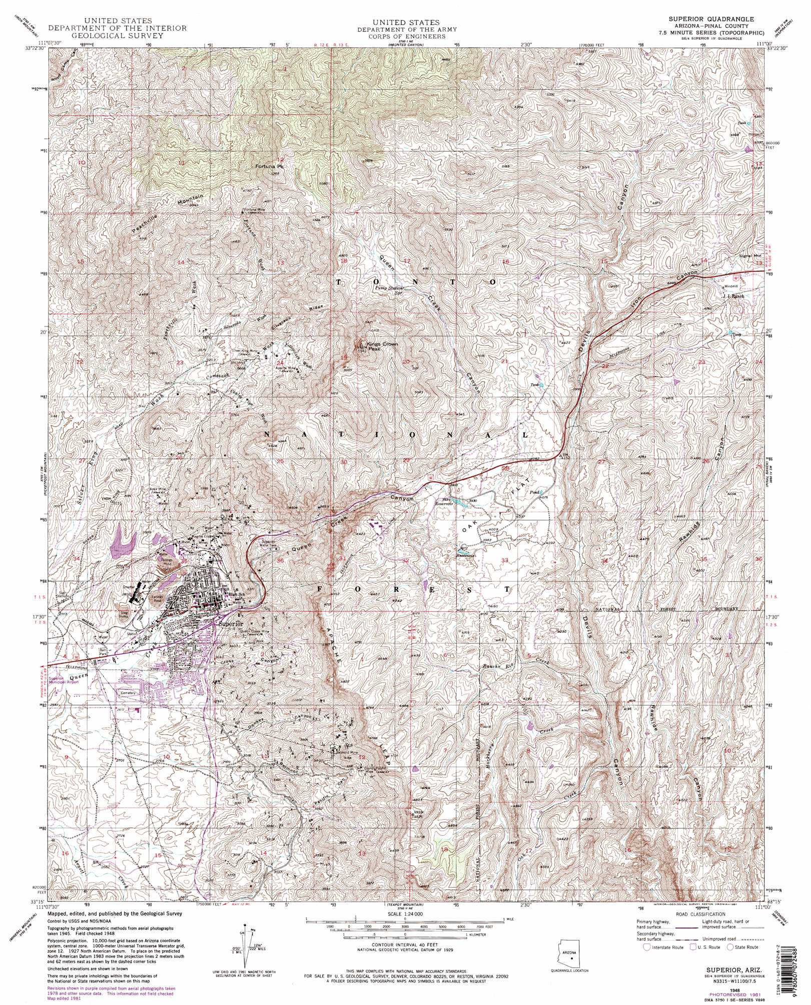
USGS Topo Quad 33111c1 - 1:24,000 scale
| Topo Map Name: | Superior |
| USGS Topo Quad ID: | 33111c1 |
| Print Size: | ca. 21 1/4" wide x 27" high |
| Southeast Coordinates: | 33.25° N latitude / 111° W longitude |
| Map Center Coordinates: | 33.3125° N latitude / 111.0625° W longitude |
| U.S. State: | AZ |
| Filename: | o33111c1.jpg |
| Download Map JPG Image: | Superior topo map 1:24,000 scale |
| Map Type: | Topographic |
| Topo Series: | 7.5´ |
| Map Scale: | 1:24,000 |
| Source of Map Images: | United States Geological Survey (USGS) |
| Alternate Map Versions: |
Superior AZ 1948, updated 1955 Download PDF Buy paper map Superior AZ 1948, updated 1981 Download PDF Buy paper map Superior AZ 1948, updated 1981 Download PDF Buy paper map Superior AZ 1949 Download PDF Buy paper map Superior AZ 2004, updated 2007 Download PDF Buy paper map Superior AZ 2011 Download PDF Buy paper map Superior AZ 2014 Download PDF Buy paper map |
| FStopo: | US Forest Service topo Superior is available: Download FStopo PDF Download FStopo TIF |
1:24,000 Topo Quads surrounding Superior
Horse Mesa Dam |
Pinyon Mountain |
Two Bar Mountain |
Salt River Peak |
Rockinstraw Mountain |
Weavers Needle |
Iron Mountain |
Haunted Canyon |
Inspiration |
Globe |
Florence Junction |
Picketpost Mountain |
Superior |
Pinal Ranch |
Pinal Peak |
Florence Ne |
Mineral Mountain |
Teapot Mountain |
Hot Tamale Peak |
El Capitan Mountain |
Florence Se |
North Butte |
Grayback |
Kearny |
Hayden |
> Back to 33111a1 at 1:100,000 scale
> Back to 33110a1 at 1:250,000 scale
> Back to U.S. Topo Maps home
Superior topo map: Gazetteer
Superior: Cliffs
Apache Leap elevation 1441m 4727′Superior: Dams
Magma Tailings Dam Number Five elevation 892m 2926′Magma Tailings Dam Number Six elevation 846m 2775′
Magma Tailings Dam Numbers One and Two elevation 846m 2775′
Magma Tailings Dam Numbers Three and Four elevation 846m 2775′
Superior: Flats
Oak Flat elevation 1209m 3966′Superior: Mines
Apache Mine elevation 1202m 3943′Apex Mine elevation 943m 3093′
Belmont Mine elevation 1153m 3782′
Fortuna Mine elevation 1368m 4488′
Grand Pacific Mine elevation 1177m 3861′
Magma Copper Mines elevation 963m 3159′
Magma Number Nine Mine elevation 1244m 4081′
Queen Creek Mine elevation 1084m 3556′
Silver King Mine elevation 1112m 3648′
Superior: Parks
Superior Stadium elevation 811m 2660′Superior: Populated Places
Superior elevation 866m 2841′Superior: Reservoirs
Cedar Tank elevation 968m 3175′East Fork Tank elevation 1486m 4875′
Headquarters Tank elevation 1419m 4655′
Horse Pasture Tank elevation 1375m 4511′
Little Cement Tank elevation 1473m 4832′
Little Rock Tank elevation 1473m 4832′
North Fork Tank elevation 1388m 4553′
Peachville Tank elevation 1238m 4061′
Superior Water Tank elevation 939m 3080′
Trail Tank elevation 1390m 4560′
Superior: Ridges
Silverado Ridge elevation 1310m 4297′Superior: Springs
Bitter Spring elevation 1154m 3786′Bored Spring elevation 917m 3008′
Fig Spring elevation 1141m 3743′
Hidden Spring elevation 882m 2893′
Mac Spring elevation 1359m 4458′
McGinnel Spring elevation 1017m 3336′
Pump Station Spring elevation 1351m 4432′
Silverrona Spring elevation 1411m 4629′
Tunnel Spring elevation 1171m 3841′
Superior: Streams
Comstock Wash elevation 988m 3241′Conley Spring Wash elevation 1034m 3392′
Fortuna Wash elevation 1135m 3723′
Hackberry Creek elevation 1086m 3562′
Oak Creek elevation 1080m 3543′
Peachville Wash elevation 994m 3261′
Rancho Rio Creek elevation 1107m 3631′
Silverado Wash elevation 1039m 3408′
Yellowjack Wash elevation 1144m 3753′
Superior: Summits
Fortuna Peak elevation 1578m 5177′Kings Crown Peak elevation 1600m 5249′
Peachville Mountain elevation 1488m 4881′
Superior: Tunnels
Queen Creek Tunnel elevation 1185m 3887′Superior: Valleys
Belmont Canyon elevation 939m 3080′Cross Canyon elevation 879m 2883′
Donkey Canyon elevation 924m 3031′
Elm Canyon elevation 880m 2887′
Iron Canyon elevation 1269m 4163′
Pacific Canyon elevation 964m 3162′
Queen Creek Canyon elevation 830m 2723′
Superior: Wells
Silver King Windmill elevation 940m 3083′Superior digital topo map on disk
Buy this Superior topo map showing relief, roads, GPS coordinates and other geographical features, as a high-resolution digital map file on DVD: