Hibbard Topo Map Arizona
To zoom in, hover over the map of Hibbard
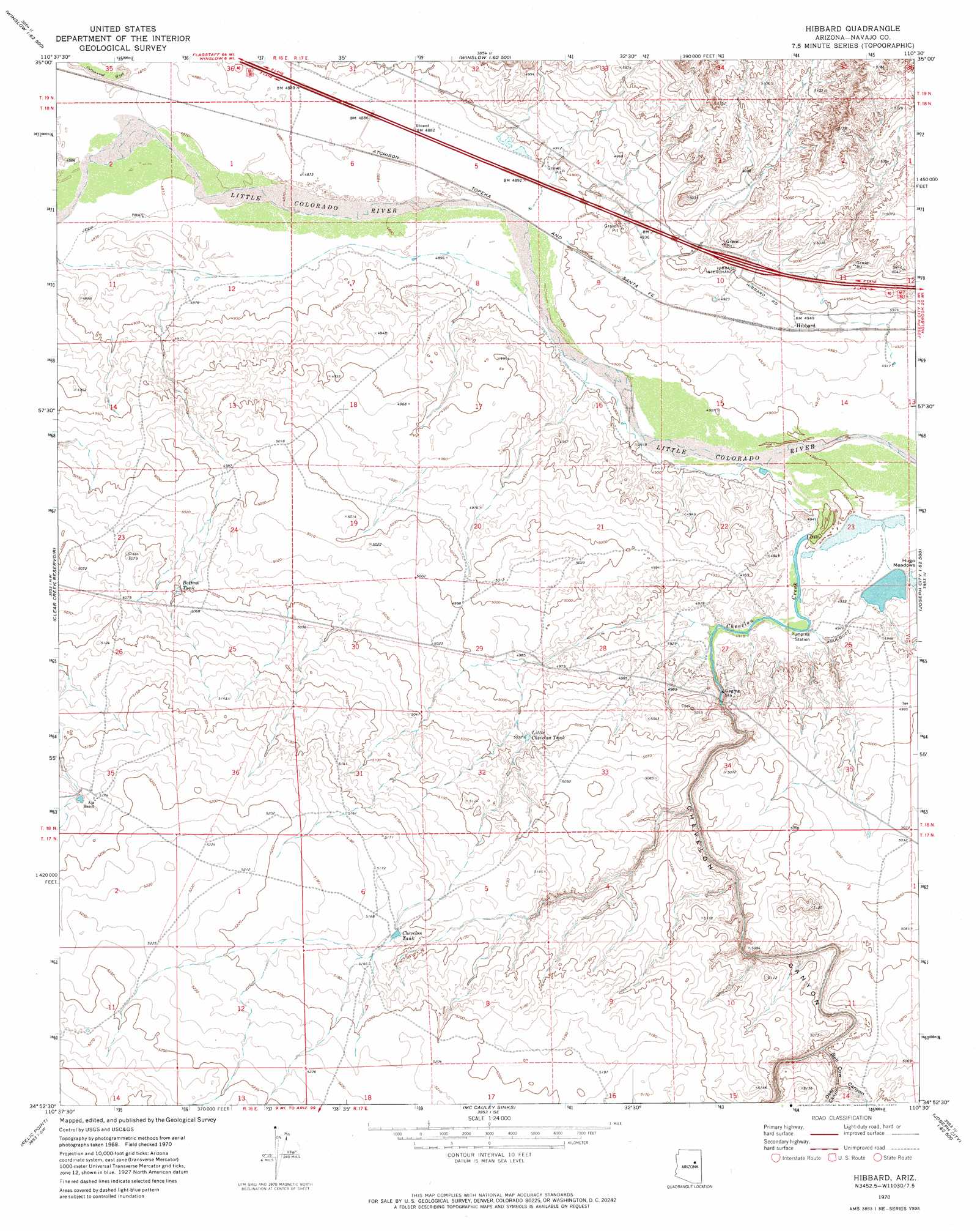
USGS Topo Quad 34110h5 - 1:24,000 scale
| Topo Map Name: | Hibbard |
| USGS Topo Quad ID: | 34110h5 |
| Print Size: | ca. 21 1/4" wide x 27" high |
| Southeast Coordinates: | 34.875° N latitude / 110.5° W longitude |
| Map Center Coordinates: | 34.9375° N latitude / 110.5625° W longitude |
| U.S. State: | AZ |
| Filename: | o34110h5.jpg |
| Download Map JPG Image: | Hibbard topo map 1:24,000 scale |
| Map Type: | Topographic |
| Topo Series: | 7.5´ |
| Map Scale: | 1:24,000 |
| Source of Map Images: | United States Geological Survey (USGS) |
| Alternate Map Versions: |
Hibbard AZ 1970, updated 1973 Download PDF Buy paper map Hibbard AZ 2011 Download PDF Buy paper map Hibbard AZ 2014 Download PDF Buy paper map |
1:24,000 Topo Quads surrounding Hibbard
Tucker Mesa Ne |
Winslow Nw |
Winslow Ne |
Standing Horse Mesa |
Rotten Bananas Butte |
Tucker Mesa |
Winslow |
Rincon Ranch |
Humpy Camp Well |
Blairs Spring |
Rock Station |
Clear Creek Reservoir |
Hibbard |
Apache Butte |
Joseph City |
Pump Ranch Tank |
Twentymile Hill |
Mccauley Sinks |
Chimney Canyon |
Saunders Draw |
Chevelon Butte |
Potato Wash North |
Potato Wash Ne |
Dry Lake Nw |
Dry Lake Ne |
> Back to 34110e1 at 1:100,000 scale
> Back to 34110a1 at 1:250,000 scale
> Back to U.S. Topo Maps home
Hibbard topo map: Gazetteer
Hibbard: Crossings
Hibbard Interchange elevation 1517m 4977′Hibbard: Populated Places
Hibbard elevation 1509m 4950′Hibbard: Reservoirs
Bottom Tank elevation 1540m 5052′Chevelon Tank elevation 1574m 5164′
Little Chevelon Tank elevation 1533m 5029′
Hibbard: Streams
Chevelon Creek elevation 1494m 4901′Hibbard: Valleys
Bell Cow Canyon elevation 1532m 5026′Chevelon Canyon elevation 1497m 4911′
Deer Canyon elevation 1535m 5036′
Hibbard digital topo map on disk
Buy this Hibbard topo map showing relief, roads, GPS coordinates and other geographical features, as a high-resolution digital map file on DVD: