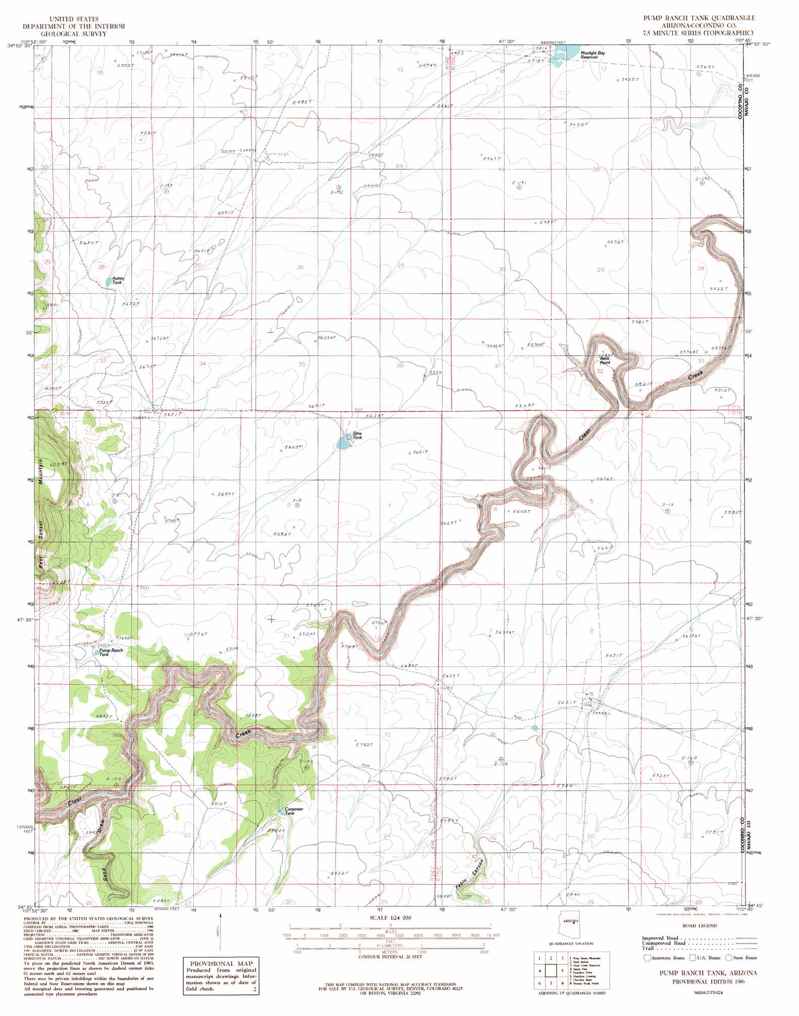
Pump Ranch Tank Topo Map Arizona
To zoom in, hover over the map of Pump Ranch Tank
USGS Topo Quad 34110g7 - 1:24,000 scale
| Topo Map Name: | Pump Ranch Tank |
| USGS Topo Quad ID: | 34110g7 |
| Print Size: | ca. 21 1/4" wide x 27" high |
| Southeast Coordinates: | 34.75° N latitude / 110.75° W longitude |
| Map Center Coordinates: | 34.8125° N latitude / 110.8125° W longitude |
| U.S. State: | AZ |
| Filename: | o34110g7.jpg |
| Download Map JPG Image: | Pump Ranch Tank topo map 1:24,000 scale |
| Map Type: | Topographic |
| Topo Series: | 7.5´ |
| Map Scale: | 1:24,000 |
| Source of Map Images: | United States Geological Survey (USGS) |
| Alternate Map Versions: |
Sunset Knoll 2 SE AZ 1955, updated 1957 Download PDF Buy paper map Pump Ranch Tank AZ 1986, updated 1986 Download PDF Buy paper map Pump Ranch Tank AZ 2011 Download PDF Buy paper map Pump Ranch Tank AZ 2014 Download PDF Buy paper map |
1:24,000 Topo Quads surrounding Pump Ranch Tank
Meteor Crater |
Tucker Mesa Sw |
Tucker Mesa |
Winslow |
Rincon Ranch |
Chavez Mountain Ne |
West Sunset Mountain |
Rock Station |
Clear Creek Reservoir |
Hibbard |
Chavez Mountain East |
Sunset Pass |
Pump Ranch Tank |
Twentymile Hill |
Mccauley Sinks |
Quayle Hill |
Hamilton Crossing |
Chevelon Butte |
Potato Wash North |
Potato Wash Ne |
Leonard Canyon |
Grama Draw |
Chevelon Crossing |
Potato Wash South |
Red Knoll |
> Back to 34110e1 at 1:100,000 scale
> Back to 34110a1 at 1:250,000 scale
> Back to U.S. Topo Maps home
Pump Ranch Tank topo map: Gazetteer
Pump Ranch Tank: Cliffs
Relic Point elevation 1677m 5501′Pump Ranch Tank: Reservoirs
Pump Ranch Tank elevation 1763m 5784′Sims Tank elevation 1720m 5643′
Pump Ranch Tank: Valleys
Pablo Canyon elevation 1647m 5403′Sand Draw elevation 1677m 5501′
Pump Ranch Tank digital topo map on disk
Buy this Pump Ranch Tank topo map showing relief, roads, GPS coordinates and other geographical features, as a high-resolution digital map file on DVD: