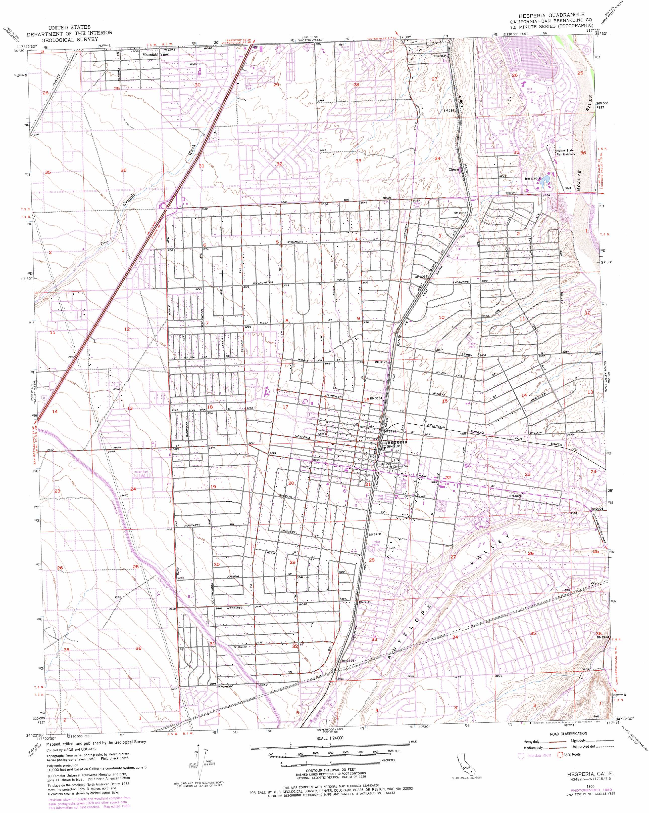
Hesperia Topo Map California
To zoom in, hover over the map of Hesperia
USGS Topo Quad 34117d3 - 1:24,000 scale
| Topo Map Name: | Hesperia |
| USGS Topo Quad ID: | 34117d3 |
| Print Size: | ca. 21 1/4" wide x 27" high |
| Southeast Coordinates: | 34.375° N latitude / 117.25° W longitude |
| Map Center Coordinates: | 34.4375° N latitude / 117.3125° W longitude |
| U.S. State: | CA |
| Filename: | o34117d3.jpg |
| Download Map JPG Image: | Hesperia topo map 1:24,000 scale |
| Map Type: | Topographic |
| Topo Series: | 7.5´ |
| Map Scale: | 1:24,000 |
| Source of Map Images: | United States Geological Survey (USGS) |
| Alternate Map Versions: |
Hesperia CA 1956, updated 1957 Download PDF Buy paper map Hesperia CA 1956, updated 1970 Download PDF Buy paper map Hesperia CA 1956, updated 1980 Download PDF Buy paper map Hesperia CA 1956, updated 1984 Download PDF Buy paper map Hesperia CA 1956, updated 1984 Download PDF Buy paper map Hesperia CA 1956, updated 1984 Download PDF Buy paper map Hesperia CA 2012 Download PDF Buy paper map Hesperia CA 2015 Download PDF Buy paper map |
1:24,000 Topo Quads surrounding Hesperia
Shadow Mountains |
Victorville Nw |
Helendale |
Turtle Valley |
Stoddard Well |
Shadow Mountains Se |
Adelanto |
Victorville |
Apple Valley North |
Fairview Valley |
Phelan |
Baldy Mesa |
Hesperia |
Apple Valley South |
Fifteenmile Valley |
Telegraph Peak |
Cajon |
Silverwood Lake |
Lake Arrowhead |
Butler Peak |
Cucamonga Peak |
Devore |
San Bernardino North |
Harrison Mountain |
Keller Peak |
> Back to 34117a1 at 1:100,000 scale
> Back to 34116a1 at 1:250,000 scale
> Back to U.S. Topo Maps home
Hesperia topo map: Gazetteer
Hesperia: Airports
Hesperia Airport elevation 1029m 3375′SCE High Desert District Heliport elevation 909m 2982′
Hesperia: Parks
Hulaville State Historic Landmark elevation 1018m 3339′Lime Street Park elevation 999m 3277′
Live Oak Park elevation 950m 3116′
Timberlane Park elevation 936m 3070′
Val Scheer Rodeo Grounds elevation 997m 3270′
Hesperia: Populated Places
Hesperia elevation 971m 3185′Mountain View Acres elevation 937m 3074′
North Star Ranch elevation 1040m 3412′
Oak Hills elevation 1050m 3444′
The Mesa elevation 969m 3179′
Thorn elevation 902m 2959′
Hesperia: Post Offices
Hesperia Post Office elevation 970m 3182′Spring Valley Lake Branch Victorville Post Office elevation 850m 2788′
Hesperia digital topo map on disk
Buy this Hesperia topo map showing relief, roads, GPS coordinates and other geographical features, as a high-resolution digital map file on DVD: