Pyramid Corners Topo Map Oklahoma
To zoom in, hover over the map of Pyramid Corners
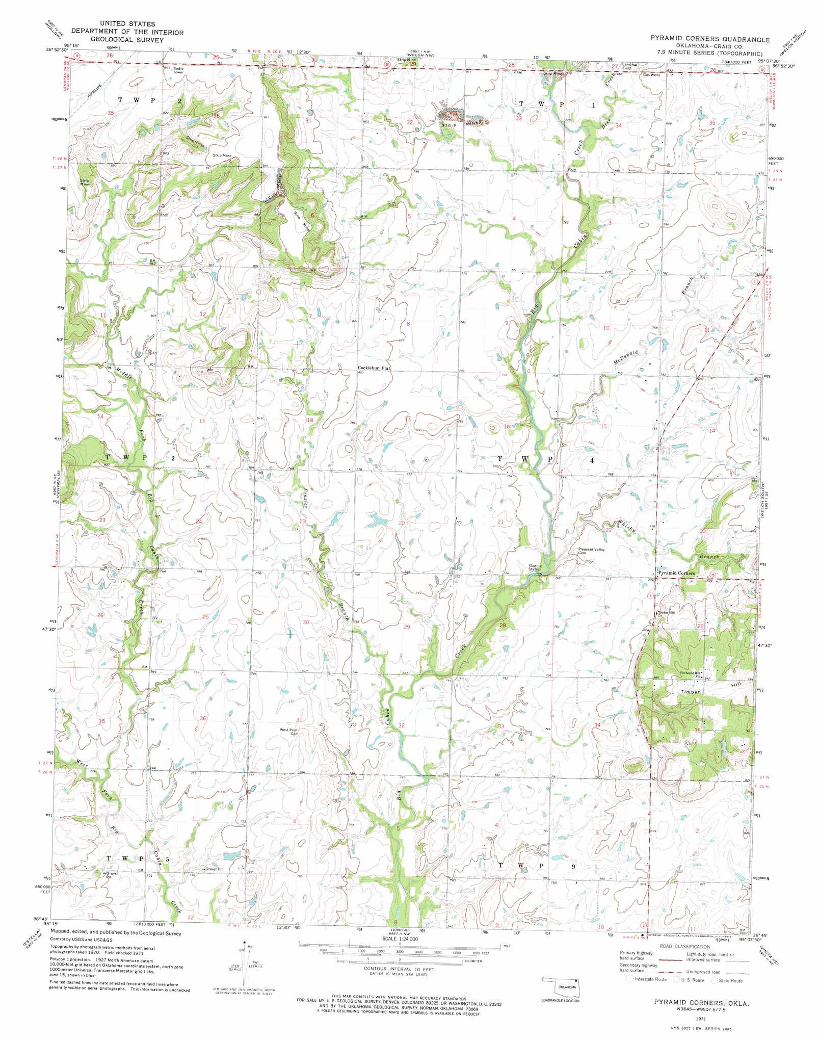
USGS Topo Quad 36095g2 - 1:24,000 scale
| Topo Map Name: | Pyramid Corners |
| USGS Topo Quad ID: | 36095g2 |
| Print Size: | ca. 21 1/4" wide x 27" high |
| Southeast Coordinates: | 36.75° N latitude / 95.125° W longitude |
| Map Center Coordinates: | 36.8125° N latitude / 95.1875° W longitude |
| U.S. State: | OK |
| Filename: | o36095g2.jpg |
| Download Map JPG Image: | Pyramid Corners topo map 1:24,000 scale |
| Map Type: | Topographic |
| Topo Series: | 7.5´ |
| Map Scale: | 1:24,000 |
| Source of Map Images: | United States Geological Survey (USGS) |
| Alternate Map Versions: |
Pyramid Corners OK 1971, updated 1973 Download PDF Buy paper map Pyramid Corners OK 2010 Download PDF Buy paper map Pyramid Corners OK 2012 Download PDF Buy paper map Pyramid Corners OK 2016 Download PDF Buy paper map |
1:24,000 Topo Quads surrounding Pyramid Corners
Valeda |
Edna |
Bartlett |
Chetopa |
Melrose |
Hayrick Mound |
Hollow |
Welch Nw |
Welch North |
Miami Nw |
Sanders |
Centralia |
Pyramid Corners |
Welch South |
Miami Sw |
Chelsea Nw |
Estella |
Vinita |
Vinita Ne |
Afton |
Chelsea |
White Oak |
Big Cabin |
Ketchum |
Bernice |
> Back to 36095e1 at 1:100,000 scale
> Back to 36094a1 at 1:250,000 scale
> Back to U.S. Topo Maps home
Pyramid Corners topo map: Gazetteer
Pyramid Corners: Dams
Dick Melendy Dam elevation 276m 905′Pyramid Corners: Populated Places
Cocklebur Flat elevation 245m 803′Pyramid Corners elevation 238m 780′
Pyramid Corners: Reservoirs
Dick Melendy Reservoir elevation 276m 905′Pyramid Corners: Streams
Deer Creek elevation 230m 754′Frazier Branch elevation 220m 721′
McDonald Branch elevation 223m 731′
Middle Fork Big Cabin Creek elevation 221m 725′
Whiskey Branch elevation 221m 725′
Pyramid Corners digital topo map on disk
Buy this Pyramid Corners topo map showing relief, roads, GPS coordinates and other geographical features, as a high-resolution digital map file on DVD: