Aztec Topo Map New Mexico
To zoom in, hover over the map of Aztec
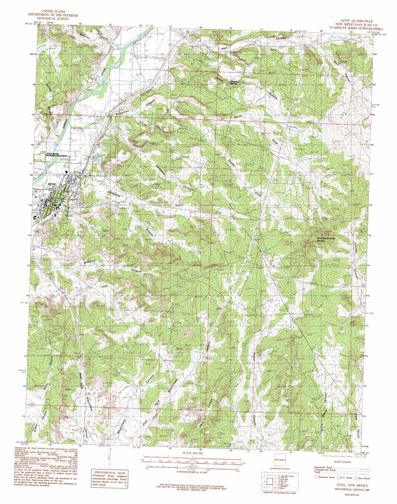
USGS Topo Quad 36107g8 - 1:24,000 scale
| Topo Map Name: | Aztec |
| USGS Topo Quad ID: | 36107g8 |
| Print Size: | ca. 21 1/4" wide x 27" high |
| Southeast Coordinates: | 36.75° N latitude / 107.875° W longitude |
| Map Center Coordinates: | 36.8125° N latitude / 107.9375° W longitude |
| U.S. State: | NM |
| Filename: | o36107g8.jpg |
| Download Map JPG Image: | Aztec topo map 1:24,000 scale |
| Map Type: | Topographic |
| Topo Series: | 7.5´ |
| Map Scale: | 1:24,000 |
| Source of Map Images: | United States Geological Survey (USGS) |
| Alternate Map Versions: |
Aztec NM 1985, updated 1985 Download PDF Buy paper map Aztec NM 2010 Download PDF Buy paper map Aztec NM 2013 Download PDF Buy paper map Aztec NM 2017 Download PDF Buy paper map |
1:24,000 Topo Quads surrounding Aztec
Redmesa |
Pinkerton Mesa |
Long Mountain |
Bondad Hill |
Ignacio |
La Plata |
Abode Downs Ranch |
Cedar Hill |
Tank Mountain |
Anastacio Spring |
Farmington North |
Flora Vista |
Aztec |
Turley |
Archuleta |
Farmington South |
Horn Canyon |
Bloomfield |
Blanco |
Cutter Canyon |
Hugh Lake |
Gallegos Trading Post |
East Fork Kutz Canyon |
Huerfanito Peak |
Fresno Canyon |
> Back to 36107e1 at 1:100,000 scale
> Back to 36106a1 at 1:250,000 scale
> Back to U.S. Topo Maps home
Aztec topo map: Gazetteer
Aztec: Canals
Aztec Ditch elevation 1749m 5738′Aztec: Parks
Aztec Historical Marker elevation 1721m 5646′Aztec Ruins National Monument elevation 1719m 5639′
Aztec Ruins National Monument Historical Marker elevation 1719m 5639′
Aztec: Populated Places
Aztec elevation 1721m 5646′Aztec: Post Offices
Aztec Post Office elevation 1721m 5646′Aztec: Streams
Farmer Arroyo elevation 1715m 5626′Jones Arroyo elevation 1755m 5757′
Aztec: Summits
Knickerbocker Peaks elevation 2057m 6748′Aztec: Valleys
Bohanan Canyon elevation 1732m 5682′Calloway Canyon elevation 1748m 5734′
Hampton Arroyo elevation 1745m 5725′
Hart Canyon elevation 1750m 5741′
Knowlton Canyon elevation 1743m 5718′
Mud Canyon elevation 1831m 6007′
North Fork Knowlton Canyon elevation 1777m 5830′
Ruins Canyon elevation 1792m 5879′
South Fork Knowlton Canyon elevation 1777m 5830′
Aztec: Wells
Hart Canyon Water Well elevation 1845m 6053′Aztec digital topo map on disk
Buy this Aztec topo map showing relief, roads, GPS coordinates and other geographical features, as a high-resolution digital map file on DVD: