Carracas Canyon Topo Map New Mexico
To zoom in, hover over the map of Carracas Canyon
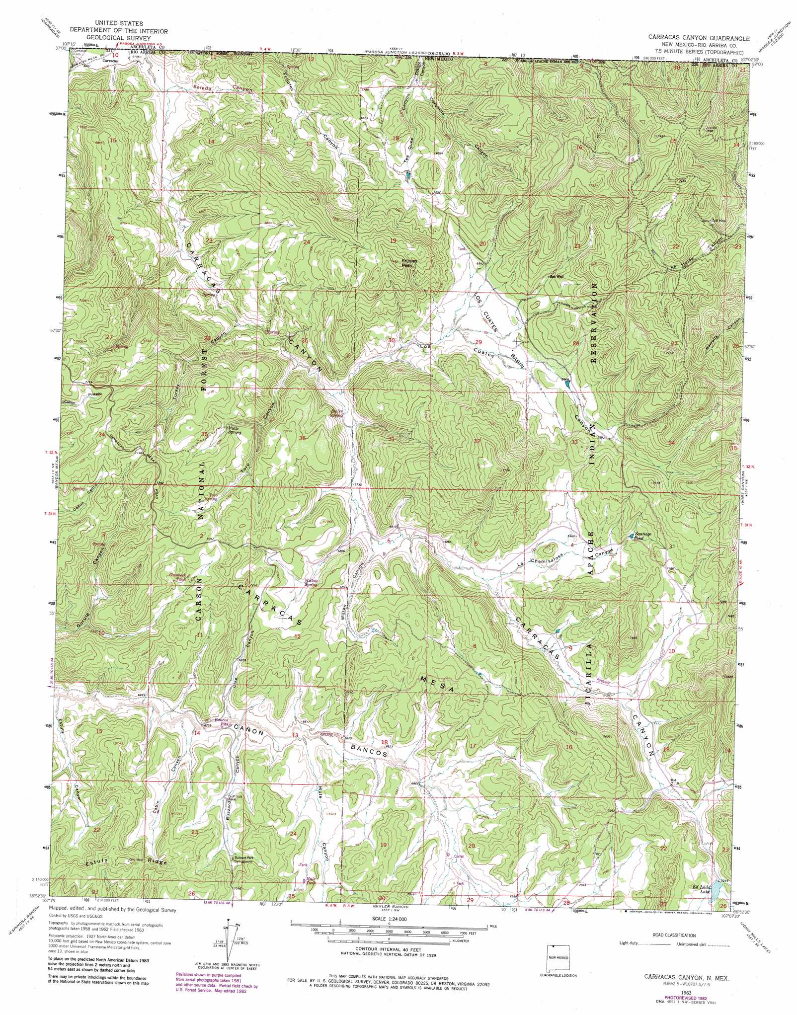
USGS Topo Quad 36107h2 - 1:24,000 scale
| Topo Map Name: | Carracas Canyon |
| USGS Topo Quad ID: | 36107h2 |
| Print Size: | ca. 21 1/4" wide x 27" high |
| Southeast Coordinates: | 36.875° N latitude / 107.125° W longitude |
| Map Center Coordinates: | 36.9375° N latitude / 107.1875° W longitude |
| U.S. State: | NM |
| Filename: | o36107h2.jpg |
| Download Map JPG Image: | Carracas Canyon topo map 1:24,000 scale |
| Map Type: | Topographic |
| Topo Series: | 7.5´ |
| Map Scale: | 1:24,000 |
| Source of Map Images: | United States Geological Survey (USGS) |
| Alternate Map Versions: |
Carracas Canyon NM 1963, updated 1967 Download PDF Buy paper map Carracas Canyon NM 1963, updated 1972 Download PDF Buy paper map Carracas Canyon NM 1963, updated 1983 Download PDF Buy paper map Carracas Canyon NM 1995, updated 1998 Download PDF Buy paper map Carracas Canyon NM 2011 Download PDF Buy paper map Carracas Canyon NM 2013 Download PDF Buy paper map Carracas Canyon NM 2017 Download PDF Buy paper map |
| FStopo: | US Forest Service topo Carracas Canyon is available: Download FStopo PDF Download FStopo TIF |
1:24,000 Topo Quads surrounding Carracas Canyon
Pargin Mountain |
Chimney Rock |
Lonetree Canyon |
Oakbrush Hill |
Serviceberry Mountain |
Allison |
Carracas |
Pagosa Junction |
Trujillo |
Edith |
Bancos Mesa Nw |
Bancos Mesa |
Carracas Canyon |
Wirt Canyon |
Dulce |
Gomez Ranch |
Espinosa Ranch |
Bixler Ranch |
John Mills Lake |
Cordova Canyon |
Fourmile Canyon |
Gobernador |
Leandro Canyon |
Cement Lake |
Cedar Canyon |
> Back to 36107e1 at 1:100,000 scale
> Back to 36106a1 at 1:250,000 scale
> Back to U.S. Topo Maps home
Carracas Canyon topo map: Gazetteer
Carracas Canyon: Basins
Los Cuates Basin elevation 2096m 6876′Carracas Canyon: Lakes
Santiago Pond elevation 2155m 7070′Carracas Canyon: Populated Places
Carracas elevation 1884m 6181′Carracas Canyon: Reservoirs
Ed Ladd Lake elevation 2208m 7244′Carracas Canyon: Ridges
Estufa Ridge elevation 2203m 7227′Carracas Canyon: Springs
Toro Spring elevation 2133m 6998′Vallo Spring elevation 2109m 6919′
Carracas Canyon: Summits
Carracas Mesa elevation 2207m 7240′Frijoles Peak elevation 2278m 7473′
Carracas Canyon: Valleys
Buzzard Canyon elevation 2061m 6761′Cabin Canyon elevation 2048m 6719′
Coronilla Canyon elevation 2022m 6633′
Dike Canyon elevation 2061m 6761′
Estufa Canyon elevation 2025m 6643′
La Chamisalosa Canyon elevation 2092m 6863′
Los Cuates Canyon elevation 2031m 6663′
Mule Canyon elevation 2071m 6794′
Tee Quee Canyon elevation 2024m 6640′
Toro Canyon elevation 2014m 6607′
Turkey Canyon elevation 1979m 6492′
Willow Canyon elevation 2062m 6765′
Carracas Canyon digital topo map on disk
Buy this Carracas Canyon topo map showing relief, roads, GPS coordinates and other geographical features, as a high-resolution digital map file on DVD: