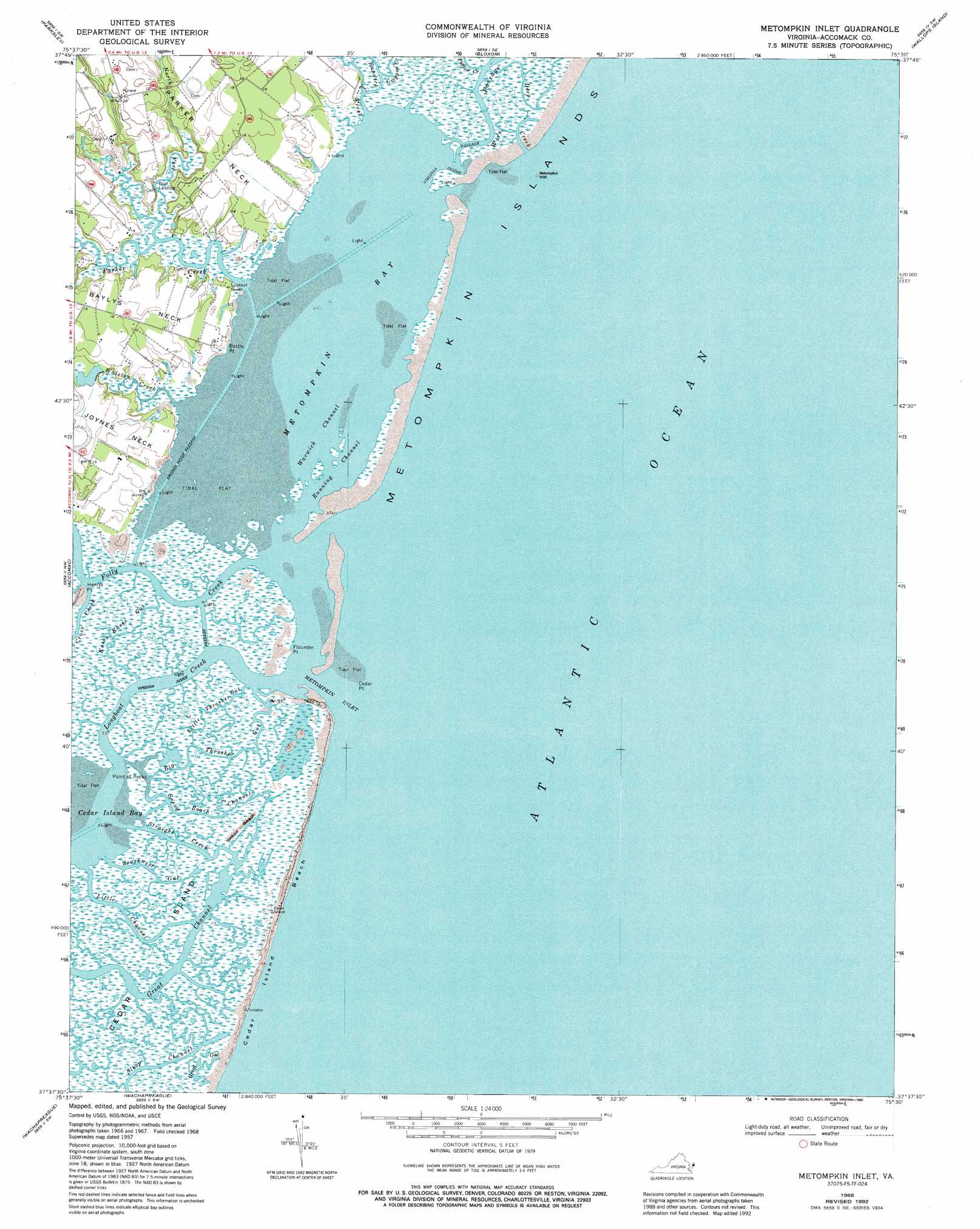
Metompkin Inlet Topo Map Virginia
To zoom in, hover over the map of Metompkin Inlet
USGS Topo Quad 37075f5 - 1:24,000 scale
| Topo Map Name: | Metompkin Inlet |
| USGS Topo Quad ID: | 37075f5 |
| Print Size: | ca. 21 1/4" wide x 27" high |
| Southeast Coordinates: | 37.625° N latitude / 75.5° W longitude |
| Map Center Coordinates: | 37.6875° N latitude / 75.5625° W longitude |
| U.S. State: | VA |
| Filename: | o37075f5.jpg |
| Download Map JPG Image: | Metompkin Inlet topo map 1:24,000 scale |
| Map Type: | Topographic |
| Topo Series: | 7.5´ |
| Map Scale: | 1:24,000 |
| Source of Map Images: | United States Geological Survey (USGS) |
| Alternate Map Versions: |
Metomkin Inlet VA 1957, updated 1958 Download PDF Buy paper map Metomkin Inlet VA 1968, updated 1971 Download PDF Buy paper map Metomkin Inlet VA 1968, updated 1980 Download PDF Buy paper map Metomkin Inlet VA 1968, updated 1984 Download PDF Buy paper map Metompkin Inlet VA 1968, updated 1986 Download PDF Buy paper map Metompkin Inlet VA 1968, updated 1992 Download PDF Buy paper map Metompkin Inlet VA 2011 Download PDF Buy paper map Metompkin Inlet VA 2013 Download PDF Buy paper map Metompkin Inlet VA 2016 Download PDF Buy paper map |
1:24,000 Topo Quads surrounding Metompkin Inlet
Crisfield |
Saxis |
Hallwood |
Chincoteague West |
Chincoteague East |
Chesconessex |
Parksley |
Bloxom |
Wallops Island |
|
Pungoteague |
Accomac |
Metompkin Inlet |
||
Exmore |
Wachapreague |
|||
Nassawadox |
Quinby Inlet |
> Back to 37075e1 at 1:100,000 scale
> Back to 37074a1 at 1:250,000 scale
> Back to U.S. Topo Maps home
Metompkin Inlet topo map: Gazetteer
Metompkin Inlet: Bays
Cedar Island Bay elevation 0m 0′Metompkin Bay elevation 0m 0′
Metompkin Inlet elevation 0m 0′
Metompkin Inlet: Beaches
Cedar Island Beach elevation 0m 0′Snead Beach elevation 1m 3′
Metompkin Inlet: Capes
Battle Point elevation 0m 0′Baylys Neck elevation 6m 19′
Cedar Point elevation 0m 0′
Flounder Point elevation 1m 3′
Henrys Point elevation 1m 3′
Parker Neck elevation 6m 19′
Point of Rocks elevation 1m 3′
Metompkin Inlet: Channels
Great Channel elevation -8m -27′Little Channel elevation 0m 0′
Round Rock Channel elevation 1m 3′
Running Channel elevation 7m 22′
Sloop Channel elevation 1m 3′
Snead Beach Channel elevation 1m 3′
Virginia Inside Passage elevation 0m 0′
Warwick Channel elevation 0m 0′
Metompkin Inlet: Dams
Walston Creek Dam elevation 3m 9′Metompkin Inlet: Guts
Big Thrasher Gut elevation 1m 3′Great Gut elevation 1m 3′
Knock Knees Gut elevation 1m 3′
Little Thrasher Gut elevation 1m 3′
Southwest Gut elevation 1m 3′
Metompkin Inlet: Islands
Cedar Island elevation 1m 3′Metompkin Inlet: Streams
Bundick Creek elevation 1m 3′Crippen Creek elevation 0m 0′
Deep Creek elevation 0m 0′
Folly Creek elevation 4m 13′
Longboat Creek elevation 0m 0′
North Fork Parker Creek elevation 0m 0′
Parker Creek elevation 0m 0′
Poplar Creek elevation 1m 3′
Straight Creek elevation 1m 3′
Walston Creek elevation -2m -7′
Metompkin Inlet digital topo map on disk
Buy this Metompkin Inlet topo map showing relief, roads, GPS coordinates and other geographical features, as a high-resolution digital map file on DVD:
Atlantic Coast (NY, NJ, PA, DE, MD, VA, NC)
Buy digital topo maps: Atlantic Coast (NY, NJ, PA, DE, MD, VA, NC)
 map DVD")