Mathews Topo Map Virginia
To zoom in, hover over the map of Mathews
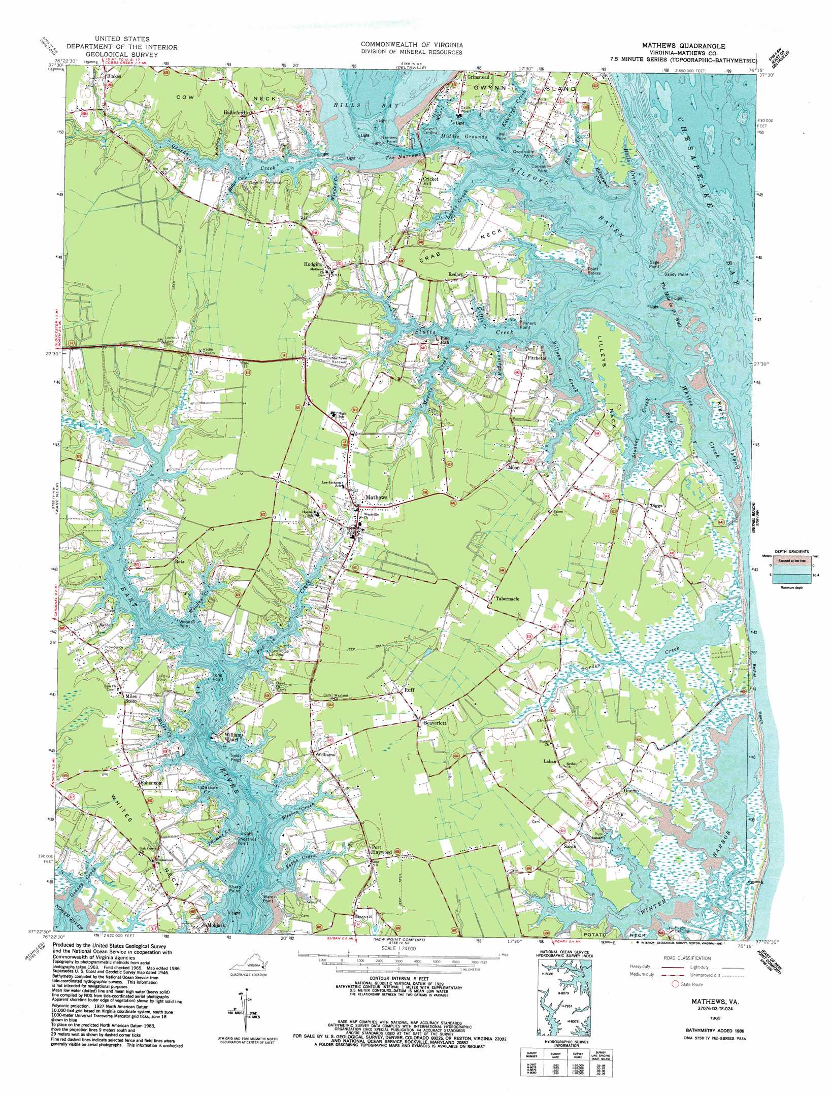
USGS Topo Quad 37076d3 - 1:24,000 scale
| Topo Map Name: | Mathews |
| USGS Topo Quad ID: | 37076d3 |
| Print Size: | ca. 21 1/4" wide x 27" high |
| Southeast Coordinates: | 37.375° N latitude / 76.25° W longitude |
| Map Center Coordinates: | 37.4375° N latitude / 76.3125° W longitude |
| U.S. State: | VA |
| Filename: | o37076d3.jpg |
| Download Map JPG Image: | Mathews topo map 1:24,000 scale |
| Map Type: | Topographic |
| Topo Series: | 7.5´ |
| Map Scale: | 1:24,000 |
| Source of Map Images: | United States Geological Survey (USGS) |
| Alternate Map Versions: |
Mathews VA 1948 Download PDF Buy paper map Mathews VA 1948 Download PDF Buy paper map Mathews VA 1965, updated 1967 Download PDF Buy paper map Mathews VA 1965, updated 1987 Download PDF Buy paper map Mathews VA 1965, updated 1987 Download PDF Buy paper map Mathews VA 2011 Download PDF Buy paper map Mathews VA 2013 Download PDF Buy paper map Mathews VA 2016 Download PDF Buy paper map |
1:24,000 Topo Quads surrounding Mathews
Urbanna |
Irvington |
Fleets Bay |
East of Fleets Bay |
West Of Nandua Creek |
Saluda |
Wilton |
Deltaville |
East Of Deltaville |
West Of Jamesville |
Gloucester |
Ware Neck |
Mathews |
Bethel Beach |
West Of Franktown |
Clay Bank |
Achilles |
New Point Comfort |
East Of New Point Comfort |
Cape Charles |
Yorktown |
Poquoson West |
Poquoson East |
East Of Poquoson East |
Elliotts Creek |
> Back to 37076a1 at 1:100,000 scale
> Back to 37076a1 at 1:250,000 scale
> Back to U.S. Topo Maps home
Mathews topo map: Gazetteer
Mathews: Bays
Hickorynut Cove elevation 0m 0′Hills Bay elevation 0m 0′
Middle Grounds elevation 0m 0′
Milford Haven elevation 0m 0′
Miller Cove elevation 1m 3′
Postle Cove elevation 0m 0′
The Hole in the Wall elevation 0m 0′
Whites Creek elevation 0m 0′
Winter Harbor elevation 1m 3′
Mathews: Capes
Chestnut Point elevation 0m 0′Cockrell Point elevation 0m 0′
Cow Neck elevation 5m 16′
Crab Neck elevation 3m 9′
Fanneys Point elevation 0m 0′
Gwynville Point elevation 1m 3′
Lilleys Neck elevation 1m 3′
Long Point elevation 0m 0′
Mill Point elevation 0m 0′
Narrows Point elevation 2m 6′
Point Breeze elevation 0m 0′
Sage Point elevation 0m 0′
Sandy Point elevation 0m 0′
Sharp Point elevation 0m 0′
Todds Point elevation 0m 0′
Ware Point elevation 0m 0′
Whites Neck elevation 1m 3′
Woodas Point elevation 0m 0′
Mathews: Channels
The Narrows elevation 0m 0′Mathews: Islands
Rigby Island elevation 0m 0′Mathews: Populated Places
Beaverlett elevation 3m 9′Blakes elevation 5m 16′
Bohannon elevation 3m 9′
Cricket Hill elevation 3m 9′
Diggs elevation 1m 3′
Fitchetts elevation 3m 9′
Hallieford elevation 3m 9′
Haven (historical) elevation 1m 3′
Haven Beach elevation 2m 6′
Hudgins elevation 3m 9′
Laban elevation 1m 3′
Mathews elevation 3m 9′
Mobjack elevation 2m 6′
Moon elevation 1m 3′
Onemo elevation 1m 3′
Port Haywood elevation 3m 9′
Redart elevation 1m 3′
Retz elevation 1m 3′
Ruff elevation 3m 9′
Sarah elevation 1m 3′
Tabernacle elevation 4m 13′
Williams elevation 1m 3′
Winter Harbor Haven elevation 1m 3′
Mathews: Streams
Back Creek elevation 0m 0′Barn Creek elevation 0m 0′
Billups Creek elevation 0m 0′
Callis Creek elevation 0m 0′
Edwards Creek elevation 0m 0′
Garden Creek elevation 2m 6′
Godsey Creek elevation 0m 0′
Hills Creek elevation 0m 0′
Hudgins Creek elevation 0m 0′
Kenney Creek elevation 0m 0′
Lanes Creek elevation 0m 0′
Miles Creek elevation 0m 0′
Morris Creek elevation 0m 0′
Put in Creek elevation 0m 0′
Raines Creek elevation 0m 0′
Stoakes Creek elevation 0m 0′
Tabbs Creek elevation 0m 0′
Thomas Creek elevation 1m 3′
Weston Creek elevation 0m 0′
Wharf Creek elevation 0m 0′
Winder Creek elevation 7m 22′
Woodas Creek elevation 0m 0′
Mathews digital topo map on disk
Buy this Mathews topo map showing relief, roads, GPS coordinates and other geographical features, as a high-resolution digital map file on DVD:
Atlantic Coast (NY, NJ, PA, DE, MD, VA, NC)
Buy digital topo maps: Atlantic Coast (NY, NJ, PA, DE, MD, VA, NC)
 map DVD")