Clay Bank Topo Map Virginia
To zoom in, hover over the map of Clay Bank
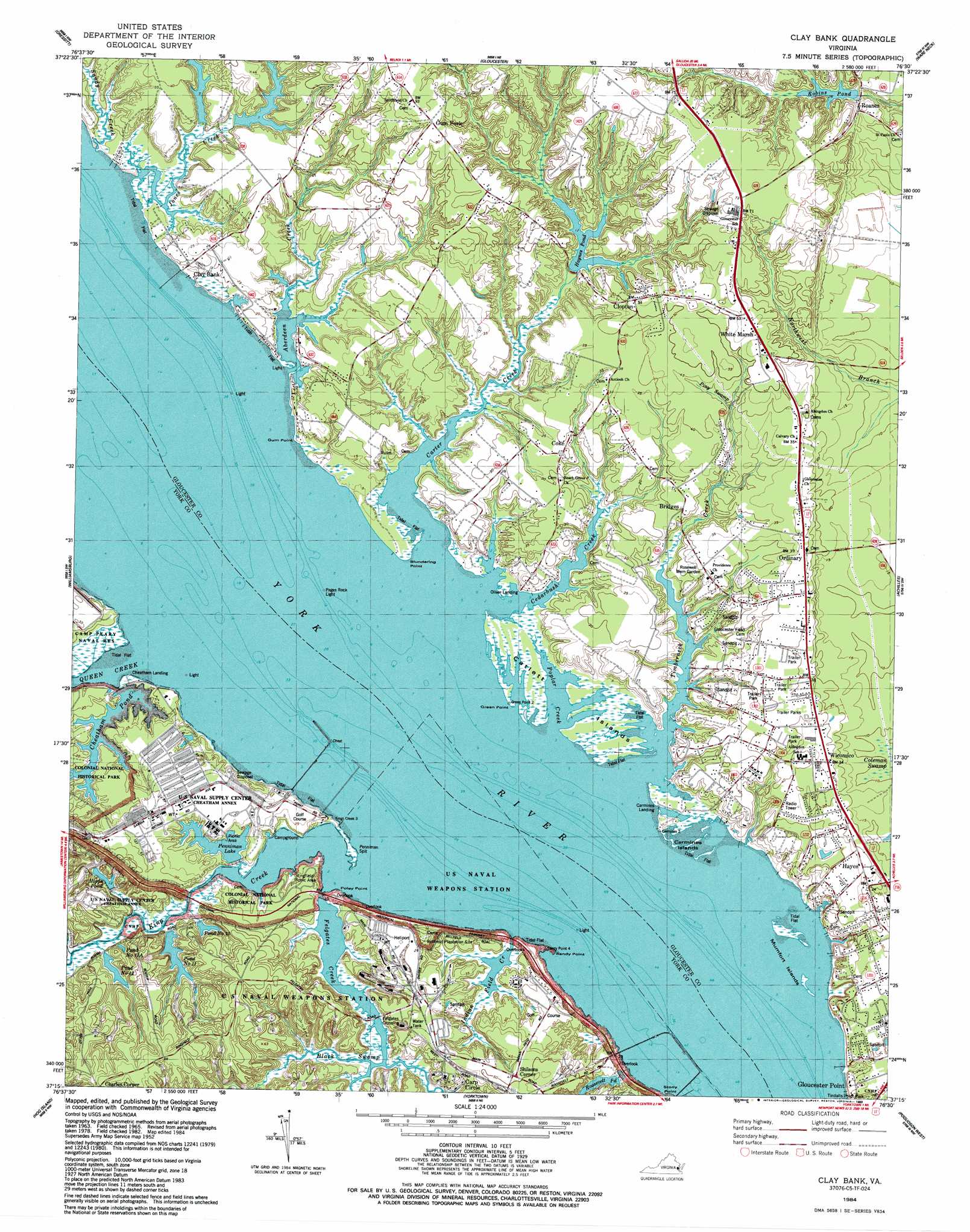
USGS Topo Quad 37076c5 - 1:24,000 scale
| Topo Map Name: | Clay Bank |
| USGS Topo Quad ID: | 37076c5 |
| Print Size: | ca. 21 1/4" wide x 27" high |
| Southeast Coordinates: | 37.25° N latitude / 76.5° W longitude |
| Map Center Coordinates: | 37.3125° N latitude / 76.5625° W longitude |
| U.S. State: | VA |
| Filename: | o37076c5.jpg |
| Download Map JPG Image: | Clay Bank topo map 1:24,000 scale |
| Map Type: | Topographic |
| Topo Series: | 7.5´ |
| Map Scale: | 1:24,000 |
| Source of Map Images: | United States Geological Survey (USGS) |
| Alternate Map Versions: |
Clay Bank VA 1952, updated 1956 Download PDF Buy paper map Clay Bank VA 1965, updated 1967 Download PDF Buy paper map Clay Bank VA 1965, updated 1973 Download PDF Buy paper map Clay Bank VA 1965, updated 1980 Download PDF Buy paper map Clay Bank VA 1984, updated 1984 Download PDF Buy paper map Clay Bank VA 1984, updated 1989 Download PDF Buy paper map Clay Bank VA 1984, updated 1989 Download PDF Buy paper map Clay Bank VA 2010 Download PDF Buy paper map Clay Bank VA 2013 Download PDF Buy paper map Clay Bank VA 2016 Download PDF Buy paper map |
1:24,000 Topo Quads surrounding Clay Bank
West Point |
Shacklefords |
Saluda |
Wilton |
Deltaville |
Toano |
Gressitt |
Gloucester |
Ware Neck |
Mathews |
Norge |
Williamsburg |
Clay Bank |
Achilles |
New Point Comfort |
Surry |
Hog Island |
Yorktown |
Poquoson West |
Poquoson East |
Runnymede |
Bacons Castle |
Mulberry Island |
Newport News North |
Hampton |
> Back to 37076a1 at 1:100,000 scale
> Back to 37076a1 at 1:250,000 scale
> Back to U.S. Topo Maps home
Clay Bank topo map: Gazetteer
Clay Bank: Airports
Naval Weapons Station-Yorktown Helipad elevation 9m 29′Clay Bank: Bars
Penniman Spit elevation 2m 6′Clay Bank: Bridges
Felgates Crossing elevation 0m 0′Clay Bank: Capes
Blundering Point elevation 0m 0′Green Point elevation 0m 0′
Gum Point elevation 0m 0′
Poley Point elevation 3m 9′
Powhatan Point elevation 0m 0′
Sandy Point elevation 0m 0′
Clay Bank: Dams
Cheatham Dam elevation 3m 9′Haynes Dam elevation 10m 32′
Penniman Dam elevation 0m 0′
Pond Number 11 Dam elevation 2m 6′
Robins Dam elevation 12m 39′
Roosevelt Pond Dam elevation 3m 9′
Weaver Dam elevation 1m 3′
Woodberry Farm Dam elevation 6m 19′
Clay Bank: Islands
Big Mumfort Island elevation 0m 0′Carmines Islands elevation 0m 0′
Catlett Islands elevation 1m 3′
Little Mumfort Island elevation 1m 3′
Mumfort Islands elevation 0m 0′
Clay Bank: Parks
Colonial National Historical Parkway elevation 6m 19′Clay Bank: Populated Places
Carp Circle elevation 6m 19′Carters Cove elevation 9m 29′
Charles Corner elevation 27m 88′
Cheatham Annex elevation 8m 26′
Clay Bank elevation 5m 16′
Clay Bank Acres elevation 4m 13′
Clopton elevation 15m 49′
Clopton Heights elevation 15m 49′
Concord elevation 1m 3′
Concord (historical) elevation 1m 3′
Country Village elevation 10m 32′
Creekwood Cove Estates elevation 9m 29′
Gum Fork elevation 25m 82′
Harbor Hills elevation 9m 29′
Hayes elevation 10m 32′
Hermitage elevation 5m 16′
Hermitage Banks elevation 6m 19′
Millwood elevation 22m 72′
Neva Terrace elevation 11m 36′
Oakdale elevation 8m 26′
Olivers Estates elevation 6m 19′
Ordinary elevation 12m 39′
Powhatan Shores elevation 8m 26′
R and L Mobile Home Park elevation 12m 39′
Roanes elevation 9m 29′
Robert Heights elevation 17m 55′
Rosewell elevation 7m 22′
Rosewell Harbor elevation 6m 19′
Shilsons Corner elevation 15m 49′
White Marsh elevation 16m 52′
Wicomico elevation 10m 32′
Wicomico Mobile Village elevation 12m 39′
York River Pines elevation 10m 32′
York View elevation 4m 13′
Clay Bank: Post Offices
Hayes Post Office elevation 7m 22′Ordinary Post Office elevation 12m 39′
White Marsh Post Office elevation 16m 52′
Wicomico Post Office elevation 10m 32′
Clay Bank: Reservoirs
Cheatham Pond elevation 0m 0′Haynes Pond elevation 10m 32′
Hipps Pond elevation 1m 3′
Jones Lake elevation 3m 9′
Penniman Lake elevation 3m 9′
Penniman Lake elevation 0m 0′
Pond Number 10 elevation 0m 0′
Pond Number 11 elevation 0m 0′
Pond Number 11A elevation 5m 16′
Pond Number 12 elevation 3m 9′
Robins Pond elevation 7m 22′
Roosevelt Pond elevation 3m 9′
Weaver Pond elevation 1m 3′
Woodberry Farm Pond elevation 6m 19′
Clay Bank: Streams
Aberdeen Creek elevation 3m 9′Black Swamp elevation 0m 0′
Carter Creek elevation 0m 0′
Cedarbush Creek elevation 0m 0′
Felgates Creek elevation 3m 9′
Indian Field Creek elevation 3m 9′
Jones Creek elevation 0m 0′
King Creek elevation 0m 0′
Piny Swamp elevation 10m 32′
Poplar Creek elevation 0m 0′
Queen Creek elevation 0m 0′
Sandy Creek elevation 0m 0′
Timberneck Creek elevation 0m 0′
Clay Bank digital topo map on disk
Buy this Clay Bank topo map showing relief, roads, GPS coordinates and other geographical features, as a high-resolution digital map file on DVD:
Atlantic Coast (NY, NJ, PA, DE, MD, VA, NC)
Buy digital topo maps: Atlantic Coast (NY, NJ, PA, DE, MD, VA, NC)
 map DVD")