Crewe East Topo Map Virginia
To zoom in, hover over the map of Crewe East
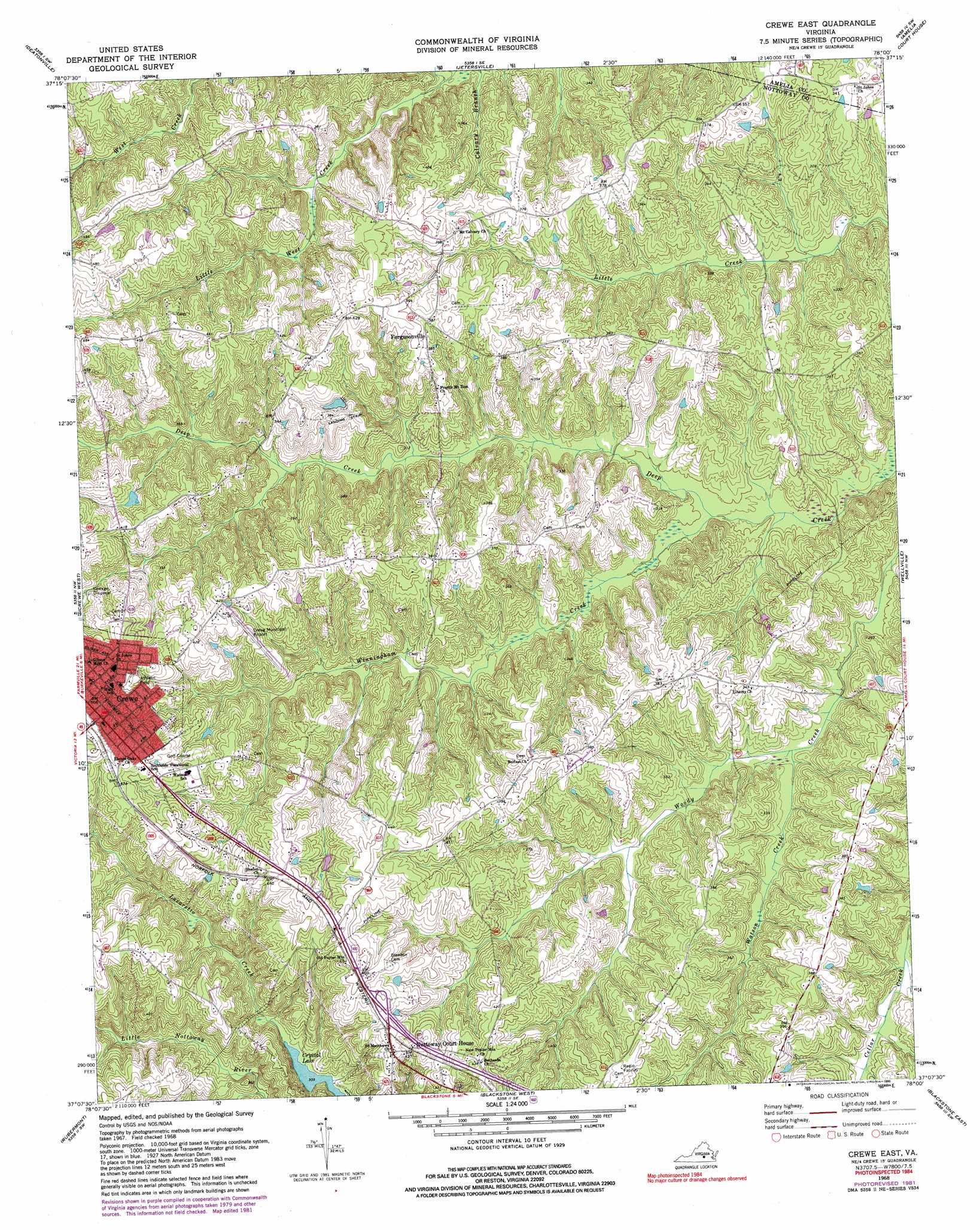
USGS Topo Quad 37078b1 - 1:24,000 scale
| Topo Map Name: | Crewe East |
| USGS Topo Quad ID: | 37078b1 |
| Print Size: | ca. 21 1/4" wide x 27" high |
| Southeast Coordinates: | 37.125° N latitude / 78° W longitude |
| Map Center Coordinates: | 37.1875° N latitude / 78.0625° W longitude |
| U.S. State: | VA |
| Filename: | o37078b1.jpg |
| Download Map JPG Image: | Crewe East topo map 1:24,000 scale |
| Map Type: | Topographic |
| Topo Series: | 7.5´ |
| Map Scale: | 1:24,000 |
| Source of Map Images: | United States Geological Survey (USGS) |
| Alternate Map Versions: |
Crewe East VA 1968, updated 1972 Download PDF Buy paper map Crewe East VA 1968, updated 1975 Download PDF Buy paper map Crewe East VA 1968, updated 1982 Download PDF Buy paper map Crewe East VA 1968, updated 1990 Download PDF Buy paper map Crewe East VA 2010 Download PDF Buy paper map Crewe East VA 2013 Download PDF Buy paper map Crewe East VA 2016 Download PDF Buy paper map |
1:24,000 Topo Quads surrounding Crewe East
Hillcrest |
Cumberland |
Ballsville |
Chula |
Clayville |
Rice |
Deatonville |
Jetersville |
Amelia Court House |
Mannboro |
Green Bay |
Crewe West |
Crewe East |
Wellville |
Hebron |
Meherrin |
Rubermont |
Blackstone West |
Blackstone East |
Darvills |
Lunenburg |
Kenbridge West |
Kenbridge East |
Danieltown |
Warfield |
> Back to 37078a1 at 1:100,000 scale
> Back to 37078a1 at 1:250,000 scale
> Back to U.S. Topo Maps home
Crewe East topo map: Gazetteer
Crewe East: Airports
Crewe Municipal Airport elevation 123m 403′Crewe East: Dams
Arnolds Dam elevation 136m 446′Austins Dam elevation 105m 344′
Sheltons Dam elevation 112m 367′
Crewe East: Populated Places
Crewe elevation 150m 492′Fergusonville elevation 115m 377′
Hendersonville (historical) elevation 137m 449′
Nottoway Court House elevation 128m 419′
Crewe East: Post Offices
Crewe Post Office elevation 150m 492′Crewe East: Streams
Lazaretto Creek elevation 94m 308′Little West Creek elevation 82m 269′
Watson Creek elevation 78m 255′
Winningham Creek elevation 73m 239′
Crewe East digital topo map on disk
Buy this Crewe East topo map showing relief, roads, GPS coordinates and other geographical features, as a high-resolution digital map file on DVD:
Western Virginia & Southern West Virginia
Buy digital topo maps: Western Virginia & Southern West Virginia