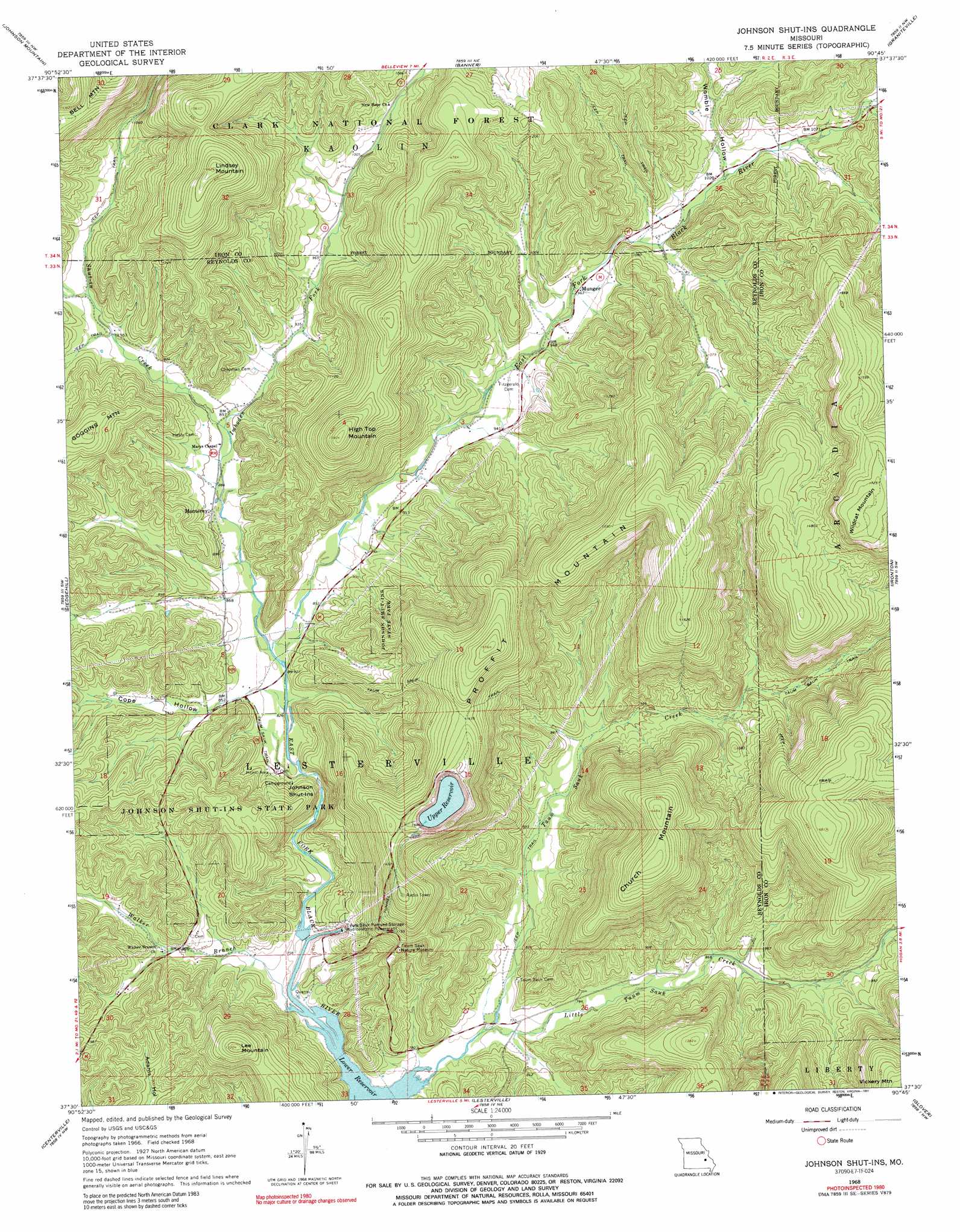
Johnson Shut-Ins Topo Map Missouri
To zoom in, hover over the map of Johnson Shut-Ins
USGS Topo Quad 37090e7 - 1:24,000 scale
| Topo Map Name: | Johnson Shut-Ins |
| USGS Topo Quad ID: | 37090e7 |
| Print Size: | ca. 21 1/4" wide x 27" high |
| Southeast Coordinates: | 37.5° N latitude / 90.75° W longitude |
| Map Center Coordinates: | 37.5625° N latitude / 90.8125° W longitude |
| U.S. State: | MO |
| Filename: | o37090e7.jpg |
| Download Map JPG Image: | Johnson Shut-Ins topo map 1:24,000 scale |
| Map Type: | Topographic |
| Topo Series: | 7.5´ |
| Map Scale: | 1:24,000 |
| Source of Map Images: | United States Geological Survey (USGS) |
| Alternate Map Versions: |
Johnson Shut-Ins MO 1968, updated 1969 Download PDF Buy paper map Johnson Shut-Ins MO 1968, updated 1973 Download PDF Buy paper map Johnson Shut-Ins MO 1968, updated 1991 Download PDF Buy paper map Johnson Shut-Ins MO 1968, updated 1991 Download PDF Buy paper map Johnson Shut-Ins MO 1999, updated 2002 Download PDF Buy paper map Johnson Shut-Ins MO 2011 Download PDF Buy paper map Johnson Shut-Ins MO 2015 Download PDF Buy paper map |
| FStopo: | US Forest Service topo Johnson Shut-ins is available: Download FStopo PDF Download FStopo TIF |
1:24,000 Topo Quads surrounding Johnson Shut-Ins
Courtois |
Palmer |
Belgrade |
Irondale |
Flat River |
Viburnum East |
Johnson Mountain |
Banner |
Graniteville |
Iron Mountain Lake |
Oates |
Edgehill |
Johnson Shut-Ins |
Ironton |
Lake Killarney |
Corridon |
Centerville |
Lesterville |
Glover |
Des Arc Ne |
Corridon Se |
Redford |
Lesterville Se |
Des Arc |
Brunot |
> Back to 37090e1 at 1:100,000 scale
> Back to 37090a1 at 1:250,000 scale
> Back to U.S. Topo Maps home
Johnson Shut-Ins topo map: Gazetteer
Johnson Shut-Ins: Dams
Middlebrook Development Lake Dam elevation 296m 971′Perdido Dam elevation 336m 1102′
Taum Sauk Upper Dam elevation 478m 1568′
Johnson Shut-Ins: Parks
Johnson's Shut-Ins State Park elevation 337m 1105′Johnson Shut-Ins: Populated Places
Monterey elevation 268m 879′Munger elevation 294m 964′
Pinkley (historical) elevation 220m 721′
Johnson Shut-Ins: Rapids
Johnson Shut-Ins elevation 245m 803′Johnson Shut-Ins: Reservoirs
Number 49 Lake elevation 296m 971′Upper Pool elevation 478m 1568′
Upper Reservoir elevation 475m 1558′
Johnson Shut-Ins: Streams
Imboden Fork elevation 254m 833′Little Taum Sauk Creek elevation 232m 761′
Shut-in Creek elevation 272m 892′
Taum Sauk Creek elevation 221m 725′
Walker Branch elevation 221m 725′
Johnson Shut-Ins: Summits
Church Mountain elevation 501m 1643′High Top Mountain elevation 483m 1584′
High Top Mountain elevation 483m 1584′
Lee Mountain elevation 405m 1328′
Lee Mountain elevation 405m 1328′
Lindsey Mountain elevation 507m 1663′
Proffit Mountain elevation 519m 1702′
Wildcat Mountain elevation 536m 1758′
Johnson Shut-Ins: Valleys
Cope Hollow elevation 257m 843′Womble Hollow elevation 313m 1026′
Johnson Shut-Ins digital topo map on disk
Buy this Johnson Shut-Ins topo map showing relief, roads, GPS coordinates and other geographical features, as a high-resolution digital map file on DVD: