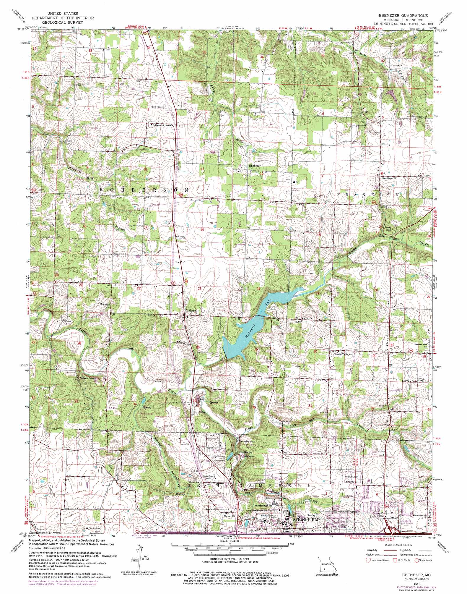
Ebenezer Topo Map Missouri
To zoom in, hover over the map of Ebenezer
USGS Topo Quad 37093c3 - 1:24,000 scale
| Topo Map Name: | Ebenezer |
| USGS Topo Quad ID: | 37093c3 |
| Print Size: | ca. 21 1/4" wide x 27" high |
| Southeast Coordinates: | 37.25° N latitude / 93.25° W longitude |
| Map Center Coordinates: | 37.3125° N latitude / 93.3125° W longitude |
| U.S. State: | MO |
| Filename: | o37093c3.jpg |
| Download Map JPG Image: | Ebenezer topo map 1:24,000 scale |
| Map Type: | Topographic |
| Topo Series: | 7.5´ |
| Map Scale: | 1:24,000 |
| Source of Map Images: | United States Geological Survey (USGS) |
| Alternate Map Versions: |
Ebenezer MO 1948 Download PDF Buy paper map Ebenezer MO 1961, updated 1962 Download PDF Buy paper map Ebenezer MO 1961, updated 1971 Download PDF Buy paper map Ebenezer MO 1961, updated 1976 Download PDF Buy paper map Ebenezer MO 2011 Download PDF Buy paper map Ebenezer MO 2015 Download PDF Buy paper map |
1:24,000 Topo Quads surrounding Ebenezer
Aldrich |
Bolivar |
Cedar Vista |
Half Way |
Charity |
Walnut Grove |
Morrisville |
Pleasant Hope |
Fair Grove |
Elkland |
Ash Grove |
Willard |
Ebenezer |
Bassville |
Strafford |
Halltown Ne |
Brookline |
Springfield |
Galloway |
Oak Grove Heights |
Billings |
Republic |
Nixa |
Ozark |
Rogersville |
> Back to 37093a1 at 1:100,000 scale
> Back to 37092a1 at 1:250,000 scale
> Back to U.S. Topo Maps home
Ebenezer topo map: Gazetteer
Ebenezer: Dams
McDaniel Lake Dam elevation 336m 1102′Rainbow Lake Dam elevation 366m 1200′
Ebenezer: Parks
Dickerson Park elevation 360m 1181′Fulbright Spring Park elevation 359m 1177′
Ritter Springs Park elevation 352m 1154′
Ebenezer: Populated Places
Avalon Park elevation 367m 1204′Ebenezer elevation 375m 1230′
Glidewell elevation 357m 1171′
Mascot elevation 377m 1236′
Pleasant Valley elevation 388m 1272′
Roseville elevation 391m 1282′
Ebenezer: Reservoirs
Lake McDaniel elevation 336m 1102′McDaniel Lake elevation 342m 1122′
Rainbow Lake elevation 366m 1200′
Ebenezer: Streams
Dickerson Branch elevation 350m 1148′Doling Branch elevation 360m 1181′
North Fork Pea Ridge Creek elevation 365m 1197′
Pea Ridge Creek elevation 335m 1099′
South Dry Sac River elevation 329m 1079′
South Fork Pea Ridge Creek elevation 365m 1197′
Spring Branch elevation 326m 1069′
Ebenezer digital topo map on disk
Buy this Ebenezer topo map showing relief, roads, GPS coordinates and other geographical features, as a high-resolution digital map file on DVD: