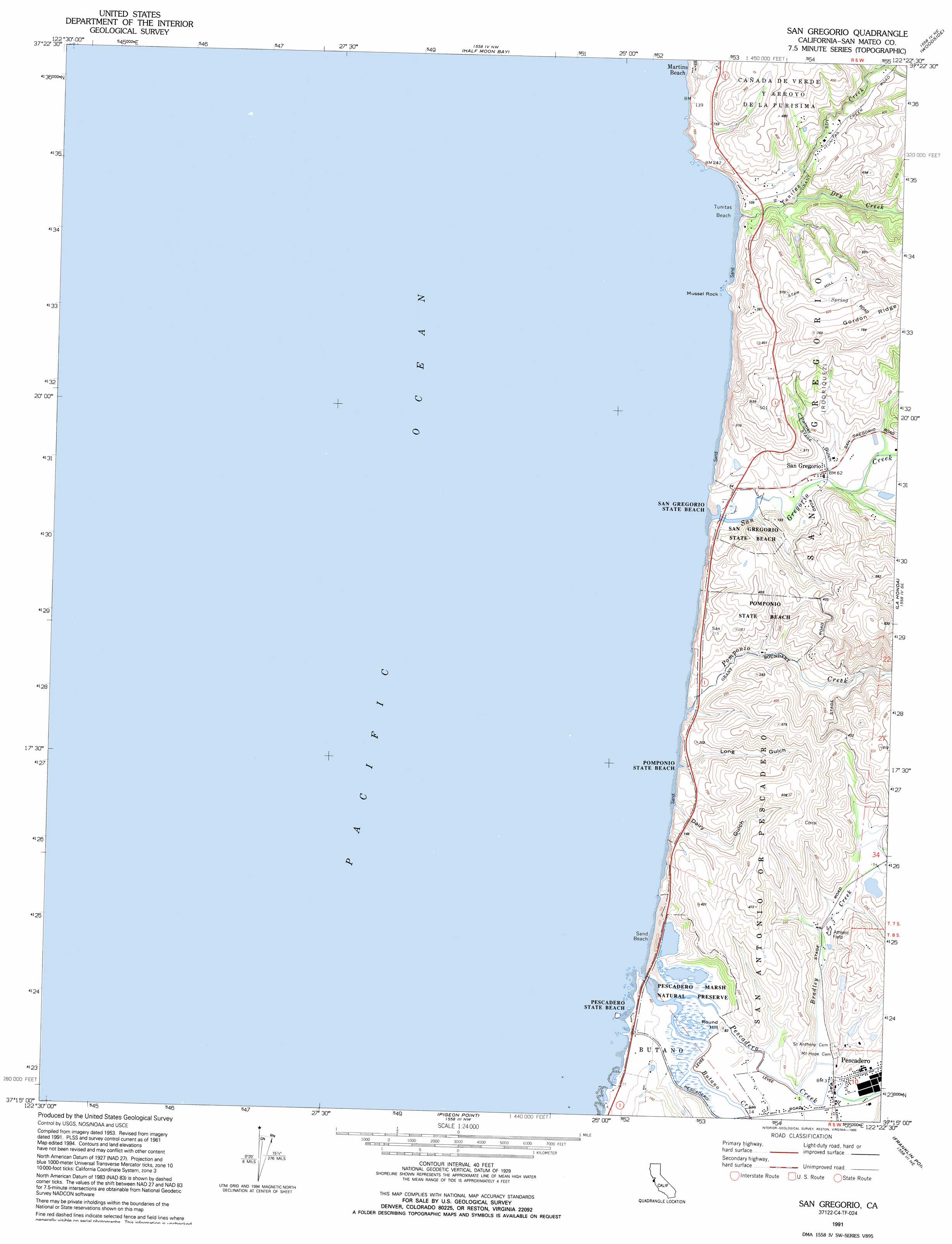
San Gregorio Topo Map California
To zoom in, hover over the map of San Gregorio
USGS Topo Quad 37122c4 - 1:24,000 scale
| Topo Map Name: | San Gregorio |
| USGS Topo Quad ID: | 37122c4 |
| Print Size: | ca. 21 1/4" wide x 27" high |
| Southeast Coordinates: | 37.25° N latitude / 122.375° W longitude |
| Map Center Coordinates: | 37.3125° N latitude / 122.4375° W longitude |
| U.S. State: | CA |
| Filename: | o37122c4.jpg |
| Download Map JPG Image: | San Gregorio topo map 1:24,000 scale |
| Map Type: | Topographic |
| Topo Series: | 7.5´ |
| Map Scale: | 1:24,000 |
| Source of Map Images: | United States Geological Survey (USGS) |
| Alternate Map Versions: |
San Gregorio CA 1955, updated 1956 Download PDF Buy paper map San Gregorio CA 1955, updated 1960 Download PDF Buy paper map San Gregorio CA 1961, updated 1961 Download PDF Buy paper map San Gregorio CA 1961, updated 1965 Download PDF Buy paper map San Gregorio CA 1961, updated 1969 Download PDF Buy paper map San Gregorio CA 1961, updated 1978 Download PDF Buy paper map San Gregorio CA 1961, updated 1987 Download PDF Buy paper map San Gregorio CA 1991, updated 1995 Download PDF Buy paper map San Gregorio CA 1997, updated 1999 Download PDF Buy paper map San Gregorio CA 2012 Download PDF Buy paper map San Gregorio CA 2015 Download PDF Buy paper map |
1:24,000 Topo Quads surrounding San Gregorio
Montara Mountain |
San Mateo |
Redwood Point |
||
Half Moon Bay |
Woodside |
Palo Alto |
||
San Gregorio |
La Honda |
Mindego Hill |
||
Pigeon Point |
Franklin Point |
Big Basin |
||
Ano Nuevo * |
Davenport |
> Back to 37122a1 at 1:100,000 scale
> Back to 37122a1 at 1:250,000 scale
> Back to U.S. Topo Maps home
San Gregorio topo map: Gazetteer
San Gregorio: Beaches
Pescadero Beach elevation 13m 42′Pomponio Beach elevation 15m 49′
San Gregorio Beach elevation 6m 19′
Sand Beach elevation 13m 42′
Tunitas Beach elevation 26m 85′
San Gregorio: Islands
Mussel Rock elevation 0m 0′San Gregorio: Parks
Pescadero Marsh Natural Preserve elevation 6m 19′Pescadero State Beach elevation 0m 0′
Pomponio State Beach elevation 0m 0′
San Gregorio State Beach elevation 7m 22′
San Mateo Coast State Beaches elevation 20m 65′
San Gregorio: Populated Places
Martins Beach elevation 6m 19′Pescadero elevation 12m 39′
San Gregorio elevation 20m 65′
San Gregorio: Post Offices
Pescadero Post Office elevation 8m 26′San Gregorio Post Office elevation 20m 65′
San Gregorio: Streams
Bradley Creek elevation 8m 26′Butano Creek elevation 0m 0′
Dry Creek elevation 11m 36′
Pescadero Creek elevation 3m 9′
Pomponio Creek elevation 5m 16′
Tunitas Creek elevation 7m 22′
San Gregorio: Summits
Round Hill elevation 28m 91′San Gregorio: Valleys
Chandler Gulch elevation 47m 154′Dairy Gulch elevation 8m 26′
Long Gulch elevation 9m 29′
Shaw Gulch elevation 48m 157′
Tahana Gulch elevation 46m 150′
San Gregorio digital topo map on disk
Buy this San Gregorio topo map showing relief, roads, GPS coordinates and other geographical features, as a high-resolution digital map file on DVD: