Ladysmith Topo Map Virginia
To zoom in, hover over the map of Ladysmith
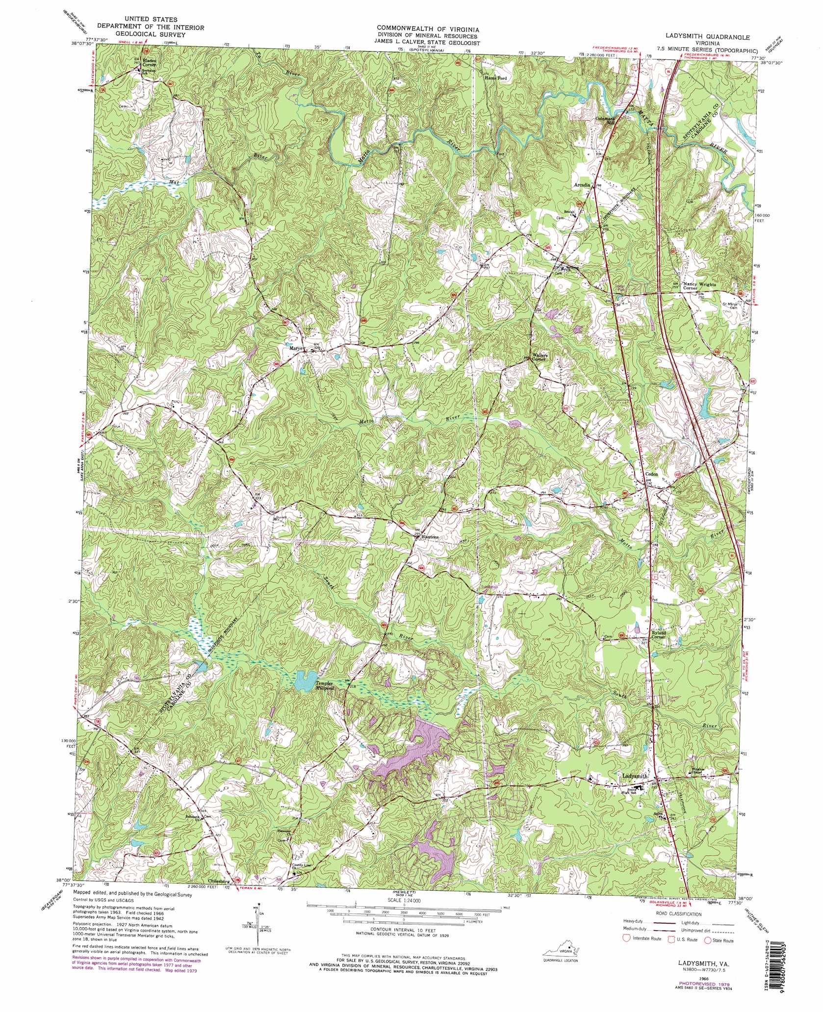
USGS Topo Quad 38077a5 - 1:24,000 scale
| Topo Map Name: | Ladysmith |
| USGS Topo Quad ID: | 38077a5 |
| Print Size: | ca. 21 1/4" wide x 27" high |
| Southeast Coordinates: | 38° N latitude / 77.5° W longitude |
| Map Center Coordinates: | 38.0625° N latitude / 77.5625° W longitude |
| U.S. State: | VA |
| Filename: | o38077a5.jpg |
| Download Map JPG Image: | Ladysmith topo map 1:24,000 scale |
| Map Type: | Topographic |
| Topo Series: | 7.5´ |
| Map Scale: | 1:24,000 |
| Source of Map Images: | United States Geological Survey (USGS) |
| Alternate Map Versions: |
Ladysmith VA 1942, updated 1961 Download PDF Buy paper map Ladysmith VA 1966, updated 1968 Download PDF Buy paper map Ladysmith VA 1966, updated 1973 Download PDF Buy paper map Ladysmith VA 1966, updated 1979 Download PDF Buy paper map Ladysmith VA 1966, updated 1979 Download PDF Buy paper map Ladysmith VA 2010 Download PDF Buy paper map Ladysmith VA 2013 Download PDF Buy paper map Ladysmith VA 2016 Download PDF Buy paper map |
1:24,000 Topo Quads surrounding Ladysmith
Mine Run |
Chancellorsville |
Salem Church |
Fredericksburg |
Passapatanzy |
Belmont |
Brokenburg |
Spotsylvania |
Guinea |
Rappahannock Academy |
Lake Anna West |
Lake Anna East |
Ladysmith |
Woodford |
Bowling Green |
Buckner |
Beaverdam |
Hewlett |
Ruther Glen |
Penola |
Dabneys |
Montpelier |
Hanover Academy |
Ashland |
Hanover |
> Back to 38077a1 at 1:100,000 scale
> Back to 38076a1 at 1:250,000 scale
> Back to U.S. Topo Maps home
Ladysmith topo map: Gazetteer
Ladysmith: Dams
Lake Devolia Dam elevation 74m 242′Lake Dover Dam elevation 82m 269′
Lake Heritage Dam elevation 71m 232′
Lake Landor Dam elevation 67m 219′
Temples Milldam elevation 66m 216′
Terrell Brothers Dam elevation 61m 200′
Ladysmith: Populated Places
Ann Wrights Corner elevation 75m 246′Arcadia elevation 82m 269′
Blades Corner elevation 88m 288′
Blantons elevation 91m 298′
Cedon elevation 71m 232′
Colemans Mill elevation 59m 193′
Davis Corner elevation 91m 298′
Hams Ford elevation 83m 272′
Ladysmith elevation 70m 229′
Ladysmith Village elevation 65m 213′
Marye elevation 97m 318′
Nancy Wrights Corner elevation 77m 252′
Ryland Corner elevation 70m 229′
Wallers Corner elevation 80m 262′
Ladysmith: Reservoirs
Lake Devolia elevation 74m 242′Lake Dover elevation 82m 269′
Lake Heritage elevation 71m 232′
Lake Landor elevation 67m 219′
Lake Sussex elevation 75m 246′
Maple Swamp elevation 68m 223′
Temples Millpond elevation 66m 216′
Ladysmith: Streams
Maple Swamp elevation 61m 200′Mat River elevation 59m 193′
Ta River elevation 58m 190′
Ladysmith digital topo map on disk
Buy this Ladysmith topo map showing relief, roads, GPS coordinates and other geographical features, as a high-resolution digital map file on DVD:
Atlantic Coast (NY, NJ, PA, DE, MD, VA, NC)
Buy digital topo maps: Atlantic Coast (NY, NJ, PA, DE, MD, VA, NC)
 map DVD")