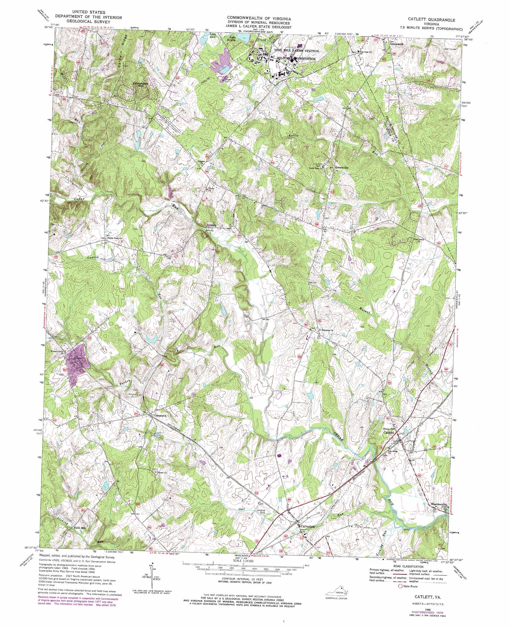
Catlett Topo Map Virginia
To zoom in, hover over the map of Catlett
USGS Topo Quad 38077f6 - 1:24,000 scale
| Topo Map Name: | Catlett |
| USGS Topo Quad ID: | 38077f6 |
| Print Size: | ca. 21 1/4" wide x 27" high |
| Southeast Coordinates: | 38.625° N latitude / 77.625° W longitude |
| Map Center Coordinates: | 38.6875° N latitude / 77.6875° W longitude |
| U.S. State: | VA |
| Filename: | o38077f6.jpg |
| Download Map JPG Image: | Catlett topo map 1:24,000 scale |
| Map Type: | Topographic |
| Topo Series: | 7.5´ |
| Map Scale: | 1:24,000 |
| Source of Map Images: | United States Geological Survey (USGS) |
| Alternate Map Versions: |
Catlett VA 1946 Download PDF Buy paper map Catlett VA 1966, updated 1969 Download PDF Buy paper map Catlett VA 1966, updated 1978 Download PDF Buy paper map Catlett VA 2011 Download PDF Buy paper map Catlett VA 2013 Download PDF Buy paper map Catlett VA 2016 Download PDF Buy paper map |
1:24,000 Topo Quads surrounding Catlett
Upperville |
Rectortown |
Middleburg |
Arcola |
Herndon |
Orlean |
Marshall |
Thoroughfare Gap |
Gainesville |
Manassas |
Jeffersonton |
Warrenton |
Catlett |
Nokesville |
Independent Hill |
Brandy Station |
Remington |
Midland |
Somerville |
Joplin |
Culpeper East |
Germanna Bridge |
Richardsville |
Storck |
Stafford |
> Back to 38077e1 at 1:100,000 scale
> Back to 38076a1 at 1:250,000 scale
> Back to U.S. Topo Maps home
Catlett topo map: Gazetteer
Catlett: Airports
Skyview Airport elevation 101m 331′Catlett: Bridges
Cedar Run Bridge elevation 66m 216′Catlett: Dams
Lake Brittle Dam elevation 114m 374′Silbersiepe Dam elevation 103m 337′
Springhill Farm Dam elevation 100m 328′
Catlett: Parks
Greenwich Park elevation 86m 282′Catlett: Populated Places
Auburn elevation 88m 288′Balls Mill elevation 96m 314′
Calverton elevation 79m 259′
Casanova elevation 115m 377′
Catlett elevation 81m 265′
Greenville elevation 117m 383′
Greenwich elevation 114m 374′
Greenwich Acres elevation 95m 311′
Oak Tree Corner elevation 109m 357′
Saint Stephens elevation 110m 360′
Turkey Run elevation 119m 390′
Weaversville elevation 68m 223′
Catlett: Post Offices
Calverton Post Office elevation 84m 275′Catlett Post Office elevation 87m 285′
Catlett: Reservoirs
Lake Anne elevation 133m 436′Lake Brittle elevation 114m 374′
Silbersiepe Pond elevation 103m 337′
Springhill Farm Pond elevation 100m 328′
Catlett: Ridges
Baldwin Ridge elevation 197m 646′Catlett: Streams
Gupton Run elevation 91m 298′Licking Run elevation 66m 216′
Mill Run elevation 103m 337′
North Fork Walnut Branch elevation 94m 308′
Owl Run elevation 66m 216′
Turkey Run elevation 69m 226′
Catlett: Summits
Luntsfords Mountain elevation 171m 561′Catlett digital topo map on disk
Buy this Catlett topo map showing relief, roads, GPS coordinates and other geographical features, as a high-resolution digital map file on DVD:
Atlantic Coast (NY, NJ, PA, DE, MD, VA, NC)
Buy digital topo maps: Atlantic Coast (NY, NJ, PA, DE, MD, VA, NC)
 map DVD")