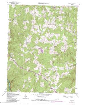
Storck Topo Map Virginia
To zoom in, hover over the map of Storck
USGS Topo Quad 38077d5 - 1:24,000 scale
| Topo Map Name: | Storck |
| USGS Topo Quad ID: | 38077d5 |
| Print Size: | ca. 21 1/4" wide x 27" high |
| Southeast Coordinates: | 38.375° N latitude / 77.5° W longitude |
| Map Center Coordinates: | 38.4375° N latitude / 77.5625° W longitude |
| U.S. State: | VA |
| Filename: | o38077d5.jpg |
| Download Map JPG Image: | Storck topo map 1:24,000 scale |
| Map Type: | Topographic |
| Topo Series: | 7.5´ |
| Map Scale: | 1:24,000 |
| Source of Map Images: | United States Geological Survey (USGS) |
| Alternate Map Versions: |
Storck VA 1953, updated 1954 Download PDF Buy paper map Storck VA 1966, updated 1968 Download PDF Buy paper map Storck VA 1966, updated 1974 Download PDF Buy paper map Storck VA 1966, updated 1978 Download PDF Buy paper map Storck VA 1966, updated 1984 Download PDF Buy paper map Storck VA 2010 Download PDF Buy paper map Storck VA 2013 Download PDF Buy paper map Storck VA 2016 Download PDF Buy paper map |
1:24,000 Topo Quads surrounding Storck
> Back to 38077a1 at 1:100,000 scale
> Back to 38076a1 at 1:250,000 scale
> Back to U.S. Topo Maps home
Storck topo map: Gazetteer
Storck: Airports
Hartwood Airport elevation 110m 360′Storck: Dams
Curtis Memorial Park Dam elevation 86m 282′Little Lake Arrowhead Dam elevation 80m 262′
Storck: Parks
Curtis Memorial Park elevation 103m 337′Willowmere Park elevation 93m 305′
Storck: Populated Places
Amsonia elevation 106m 347′Ashburn Hills elevation 98m 321′
Barrington Woods elevation 95m 311′
Beverly Estates elevation 103m 337′
Brandy Hills elevation 102m 334′
Cannon Knolls elevation 96m 314′
Carrera Estates elevation 94m 308′
Cedar Knolls Estates elevation 95m 311′
Chesterfield elevation 98m 321′
Chesterwood elevation 93m 305′
Christy Farm elevation 78m 255′
Concord elevation 100m 328′
Concord Estates elevation 111m 364′
Cool River elevation 80m 262′
Country Wood Estates elevation 81m 265′
Crestwood elevation 99m 324′
Cropp elevation 122m 400′
Cropp Road Estates elevation 111m 364′
Crown Manor elevation 94m 308′
Cypress Estates elevation 100m 328′
Davis Corner elevation 109m 357′
Deep Run elevation 99m 324′
Diamond Park elevation 109m 357′
Dodds Corner elevation 117m 383′
Eagles Nest elevation 109m 357′
Gauntlet Estates elevation 97m 318′
Georgetown West elevation 85m 278′
Glendie elevation 119m 390′
Hampshire Forest elevation 105m 344′
Hartlake Estates elevation 87m 285′
Hartwood elevation 110m 360′
Hartwood Manor elevation 100m 328′
Hartwood Meadows elevation 83m 272′
Hartwood Village elevation 99m 324′
Harwill Acres elevation 100m 328′
Heflin elevation 120m 393′
Hoys Way elevation 108m 354′
Hunters Pond elevation 88m 288′
Ivyglen elevation 100m 328′
Keatwood elevation 100m 328′
Kings Grant elevation 65m 213′
Lakeland Forest elevation 91m 298′
Laurelwood elevation 111m 364′
Long Branch elevation 94m 308′
Majestic Ridge Estates elevation 121m 396′
Manor Wood Estates elevation 91m 298′
Mansefield elevation 119m 390′
Marsh Run Estates elevation 96m 314′
Milburn Estates elevation 113m 370′
Nellie Estates elevation 104m 341′
Norwood Hills elevation 129m 423′
Parkside elevation 84m 275′
Paynes Corner elevation 124m 406′
Rappahannock Ridge Estates elevation 99m 324′
Red Hill elevation 87m 285′
Richland Forest elevation 88m 288′
Rose Hill Farms elevation 91m 298′
Rosedale elevation 89m 291′
Roseville elevation 93m 305′
Roseville Heights elevation 96m 314′
Roseville Plantation elevation 93m 305′
Rosewood Estates elevation 98m 321′
Royal Hills Estates elevation 98m 321′
Seven Lakes elevation 74m 242′
Seymour Knolls elevation 109m 357′
Shackelford Estates elevation 106m 347′
Sherwood Forest elevation 90m 295′
Skidmore Corner elevation 95m 311′
Skyline Hills elevation 108m 354′
Stefaniga elevation 123m 403′
Stefaniga Road elevation 78m 255′
Stonehouse Wooded Estates elevation 103m 337′
Stony Hill Estates elevation 94m 308′
Storck elevation 96m 314′
Storck Run elevation 106m 347′
Tacketts Farm elevation 96m 314′
The Blake Farm elevation 94m 308′
The Cascades elevation 94m 308′
The Estates elevation 83m 272′
The Preserve on Aquia Creek elevation 72m 236′
The Willows elevation 104m 341′
Timberidge elevation 73m 239′
Valhalla elevation 100m 328′
Walden Ten elevation 96m 314′
Water Edge Estates elevation 71m 232′
Whitestone elevation 93m 305′
Willowmere elevation 91m 298′
Windsor Forest elevation 73m 239′
Winslow Heights elevation 94m 308′
Storck: Post Offices
Cropp Post Office (historical) elevation 122m 400′Storck: Reservoirs
Curtis Park Lake elevation 86m 282′Little Lake Arrowhead elevation 80m 262′
Storck: Streams
Potomac Run elevation 59m 193′Richland Run elevation 37m 121′
Storck digital topo map on disk
Buy this Storck topo map showing relief, roads, GPS coordinates and other geographical features, as a high-resolution digital map file on DVD:
Atlantic Coast (NY, NJ, PA, DE, MD, VA, NC)
Buy digital topo maps: Atlantic Coast (NY, NJ, PA, DE, MD, VA, NC)


