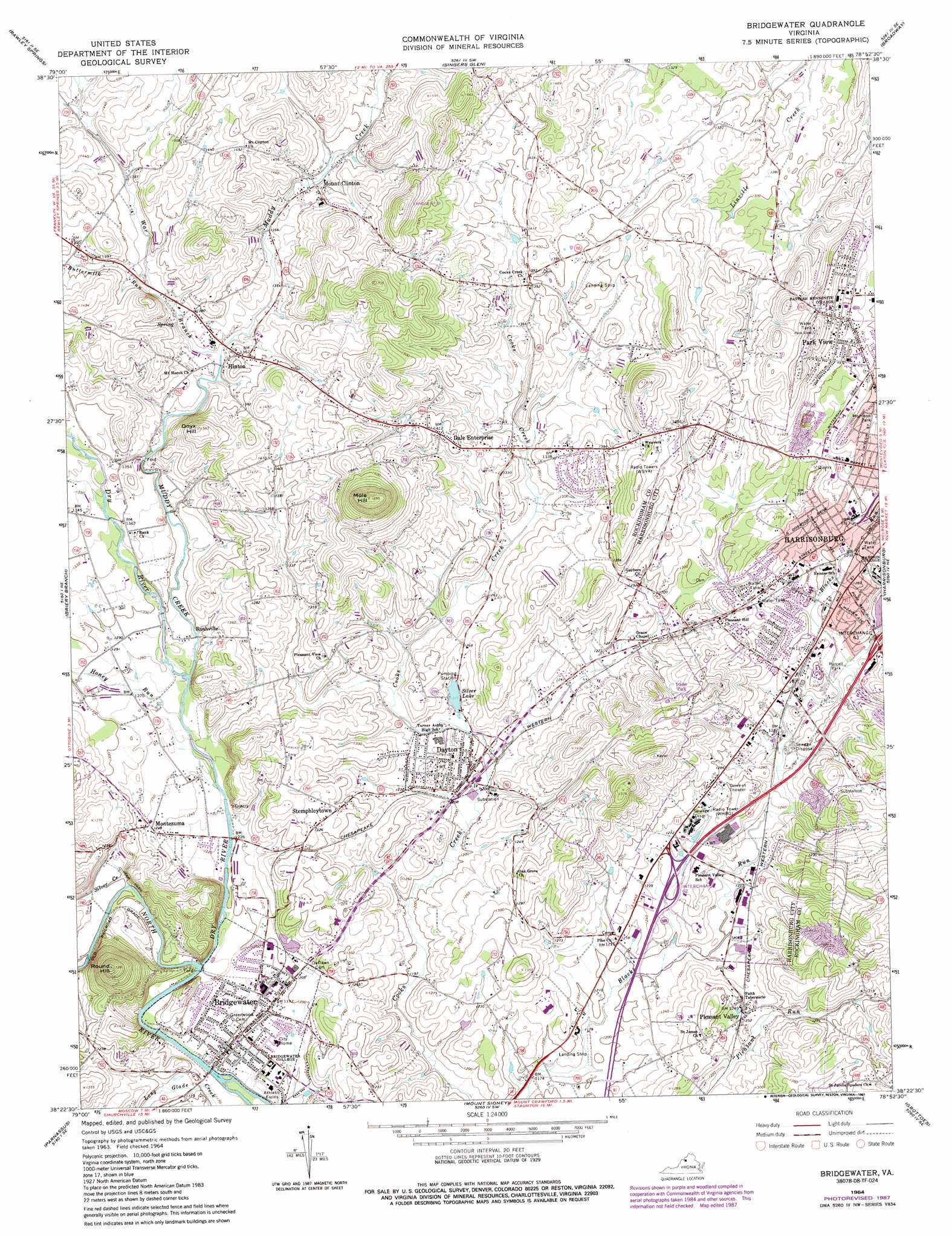
Bridgewater Topo Map Virginia
To zoom in, hover over the map of Bridgewater
USGS Topo Quad 38078d8 - 1:24,000 scale
| Topo Map Name: | Bridgewater |
| USGS Topo Quad ID: | 38078d8 |
| Print Size: | ca. 21 1/4" wide x 27" high |
| Southeast Coordinates: | 38.375° N latitude / 78.875° W longitude |
| Map Center Coordinates: | 38.4375° N latitude / 78.9375° W longitude |
| U.S. State: | VA |
| Filename: | o38078d8.jpg |
| Download Map JPG Image: | Bridgewater topo map 1:24,000 scale |
| Map Type: | Topographic |
| Topo Series: | 7.5´ |
| Map Scale: | 1:24,000 |
| Source of Map Images: | United States Geological Survey (USGS) |
| Alternate Map Versions: |
Bridgewater VA 1964, updated 1966 Download PDF Buy paper map Bridgewater VA 1964, updated 1969 Download PDF Buy paper map Bridgewater VA 1964, updated 1973 Download PDF Buy paper map Bridgewater VA 1964, updated 1978 Download PDF Buy paper map Bridgewater VA 1964, updated 1987 Download PDF Buy paper map Bridgewater VA 1989, updated 1995 Download PDF Buy paper map Bridgewater VA 2002, updated 2004 Download PDF Buy paper map Bridgewater VA 2010 Download PDF Buy paper map Bridgewater VA 2013 Download PDF Buy paper map Bridgewater VA 2016 Download PDF Buy paper map |
1:24,000 Topo Quads surrounding Bridgewater
Fort Seybert |
Cow Knob |
Fulks Run |
Timberville |
New Market |
Brandywine |
Rawley Springs |
Singers Glen |
Broadway |
Tenth Legion |
Reddish Knob |
Briery Branch |
Bridgewater |
Harrisonburg |
Elkton West |
Stokesville |
Parnassus |
Mount Sidney |
Grottoes |
Mcgaheysville |
Churchville |
Staunton |
Fort Defiance |
Crimora |
Browns Cove |
> Back to 38078a1 at 1:100,000 scale
> Back to 38078a1 at 1:250,000 scale
> Back to U.S. Topo Maps home
Bridgewater topo map: Gazetteer
Bridgewater: Airports
Lester Frank Landing Strip elevation 412m 1351′Pure Village Landing Strip elevation 358m 1174′
Bridgewater: Crossings
Interchange 243 elevation 377m 1236′Interchange 245 elevation 441m 1446′
Bridgewater: Dams
Silver Lake Dam elevation 370m 1213′Bridgewater: Parks
Bomberger Field elevation 435m 1427′Bridgewater Historic District elevation 359m 1177′
Dayton Historic District elevation 376m 1233′
Gehman Field elevation 437m 1433′
Hillandale Park elevation 392m 1286′
Memorial Stadium elevation 399m 1309′
Purcell Park elevation 384m 1259′
Ramblewood Field elevation 396m 1299′
Turt Field elevation 436m 1430′
Bridgewater: Populated Places
Bridgewater elevation 359m 1177′Coakley Town elevation 430m 1410′
Dale Enterprise elevation 428m 1404′
Dayton elevation 367m 1204′
Hinton elevation 418m 1371′
Montezuma elevation 381m 1250′
Mount Clinton elevation 421m 1381′
New Erection elevation 426m 1397′
Park View elevation 437m 1433′
Pleasant Valley elevation 383m 1256′
Rushville elevation 396m 1299′
Stemphleytown elevation 399m 1309′
Bridgewater: Post Offices
Dayton Post Office elevation 366m 1200′Pleasant Valley Post Office elevation 390m 1279′
Wissens Mill Post Office (historical) elevation 430m 1410′
Bridgewater: Reservoirs
Silver Lake elevation 370m 1213′Bridgewater: Springs
Mill Pond Spring elevation 370m 1213′Bridgewater: Streams
Buttermilk Run elevation 413m 1354′Dry River elevation 359m 1177′
Honey Run elevation 381m 1250′
Muddy Creek elevation 383m 1256′
Patterson Creek elevation 432m 1417′
Silver Creek elevation 365m 1197′
War Branch elevation 406m 1332′
Bridgewater: Summits
Mole Hill elevation 575m 1886′Onyx Hill elevation 482m 1581′
Round Hill elevation 526m 1725′
Shavers Hill elevation 480m 1574′
Bridgewater digital topo map on disk
Buy this Bridgewater topo map showing relief, roads, GPS coordinates and other geographical features, as a high-resolution digital map file on DVD:
Western Virginia & Southern West Virginia
Buy digital topo maps: Western Virginia & Southern West Virginia