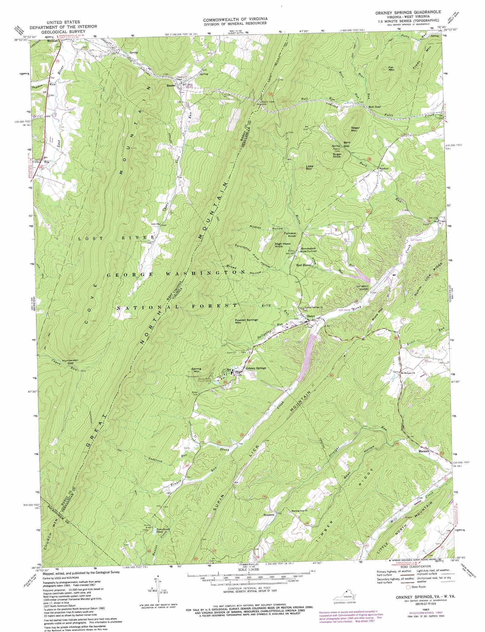
Orkney Springs Topo Map Virginia
To zoom in, hover over the map of Orkney Springs
USGS Topo Quad 38078g7 - 1:24,000 scale
| Topo Map Name: | Orkney Springs |
| USGS Topo Quad ID: | 38078g7 |
| Print Size: | ca. 21 1/4" wide x 27" high |
| Southeast Coordinates: | 38.75° N latitude / 78.75° W longitude |
| Map Center Coordinates: | 38.8125° N latitude / 78.8125° W longitude |
| U.S. States: | VA, WV |
| Filename: | o38078g7.jpg |
| Download Map JPG Image: | Orkney Springs topo map 1:24,000 scale |
| Map Type: | Topographic |
| Topo Series: | 7.5´ |
| Map Scale: | 1:24,000 |
| Source of Map Images: | United States Geological Survey (USGS) |
| Alternate Map Versions: |
Orkney Springs VA 1967, updated 1969 Download PDF Buy paper map Orkney Springs VA 1967, updated 1973 Download PDF Buy paper map Orkney Springs VA 1967, updated 1987 Download PDF Buy paper map Orkney Springs VA 1994, updated 1997 Download PDF Buy paper map Orkney Springs VA 2011 Download PDF Buy paper map Orkney Springs VA 2013 Download PDF Buy paper map Orkney Springs VA 2016 Download PDF Buy paper map |
| FStopo: | US Forest Service topo Orkney Springs is available: Download FStopo PDF Download FStopo TIF |
1:24,000 Topo Quads surrounding Orkney Springs
Rig |
Moorefield |
Needmore |
Baker |
Wardensville |
Petersburg East |
Lost River State Park |
Lost City |
Wolf Gap |
Woodstock |
Milam |
Bergton |
Orkney Springs |
Conicville |
Edinburg |
Cow Knob |
Fulks Run |
Timberville |
New Market |
Hamburg |
Rawley Springs |
Singers Glen |
Broadway |
Tenth Legion |
Stanley |
> Back to 38078e1 at 1:100,000 scale
> Back to 38078a1 at 1:250,000 scale
> Back to U.S. Topo Maps home
Orkney Springs topo map: Gazetteer
Orkney Springs: Airports
Sky Bryce Airport elevation 382m 1253′Orkney Springs: Dams
Lake Carroll Dam elevation 396m 1299′Stony Creek Number Nine Dam elevation 439m 1440′
Orkney Springs: Gaps
Barb Gap elevation 442m 1450′Bull Gap elevation 432m 1417′
Hunkerson Gap elevation 599m 1965′
Orkney Springs: Populated Places
Basore elevation 535m 1755′Basye elevation 404m 1325′
Hepners elevation 444m 1456′
Macanie elevation 349m 1145′
Orkney Springs elevation 454m 1489′
Orkney Springs: Reservoirs
Lake Carroll elevation 396m 1299′Lake Laura elevation 439m 1440′
Tomahawk Pond elevation 472m 1548′
Orkney Springs: Ridges
Timber Ridge elevation 504m 1653′Orkney Springs: Springs
Ervin May Spring elevation 589m 1932′Lower Cove Spring elevation 632m 2073′
Shenandoah Alum Springs elevation 422m 1384′
Upper Cove Spring elevation 564m 1850′
Orkney Springs: Streams
Alum Run elevation 396m 1299′Anderson Run elevation 457m 1499′
Barb Run elevation 366m 1200′
Bean Run elevation 448m 1469′
Bear Run elevation 432m 1417′
Beetle Run elevation 384m 1259′
Bull Run elevation 432m 1417′
Cullers Run elevation 486m 1594′
Kelly Run elevation 404m 1325′
Rinker Run elevation 434m 1423′
Saltpeter Run elevation 396m 1299′
Snyder Run elevation 472m 1548′
Orkney Springs: Summits
Bryce Mountain elevation 518m 1699′Fat Mountain elevation 624m 2047′
Freds Mountain elevation 558m 1830′
Furnace Knob elevation 488m 1601′
High Head Knob elevation 561m 1840′
Little Mountain elevation 621m 2037′
Little North Mountain elevation 452m 1482′
Powder Springs Mountain elevation 556m 1824′
Segar Mountain elevation 590m 1935′
Spring Mountain elevation 613m 2011′
Sugar Knob elevation 577m 1893′
Orkney Springs: Trails
Hunkerson Gap Trail elevation 627m 2057′Hunkerson Gap Trail elevation 627m 2057′
Orkney Springs: Valleys
Bean Hollow elevation 359m 1177′Broad Hollow elevation 473m 1551′
Persimmon Pond Hollow elevation 475m 1558′
Wildcat Hollow elevation 468m 1535′
Orkney Springs digital topo map on disk
Buy this Orkney Springs topo map showing relief, roads, GPS coordinates and other geographical features, as a high-resolution digital map file on DVD:
Western Virginia & Southern West Virginia
Buy digital topo maps: Western Virginia & Southern West Virginia