Sweet Springs Topo Map Missouri
To zoom in, hover over the map of Sweet Springs
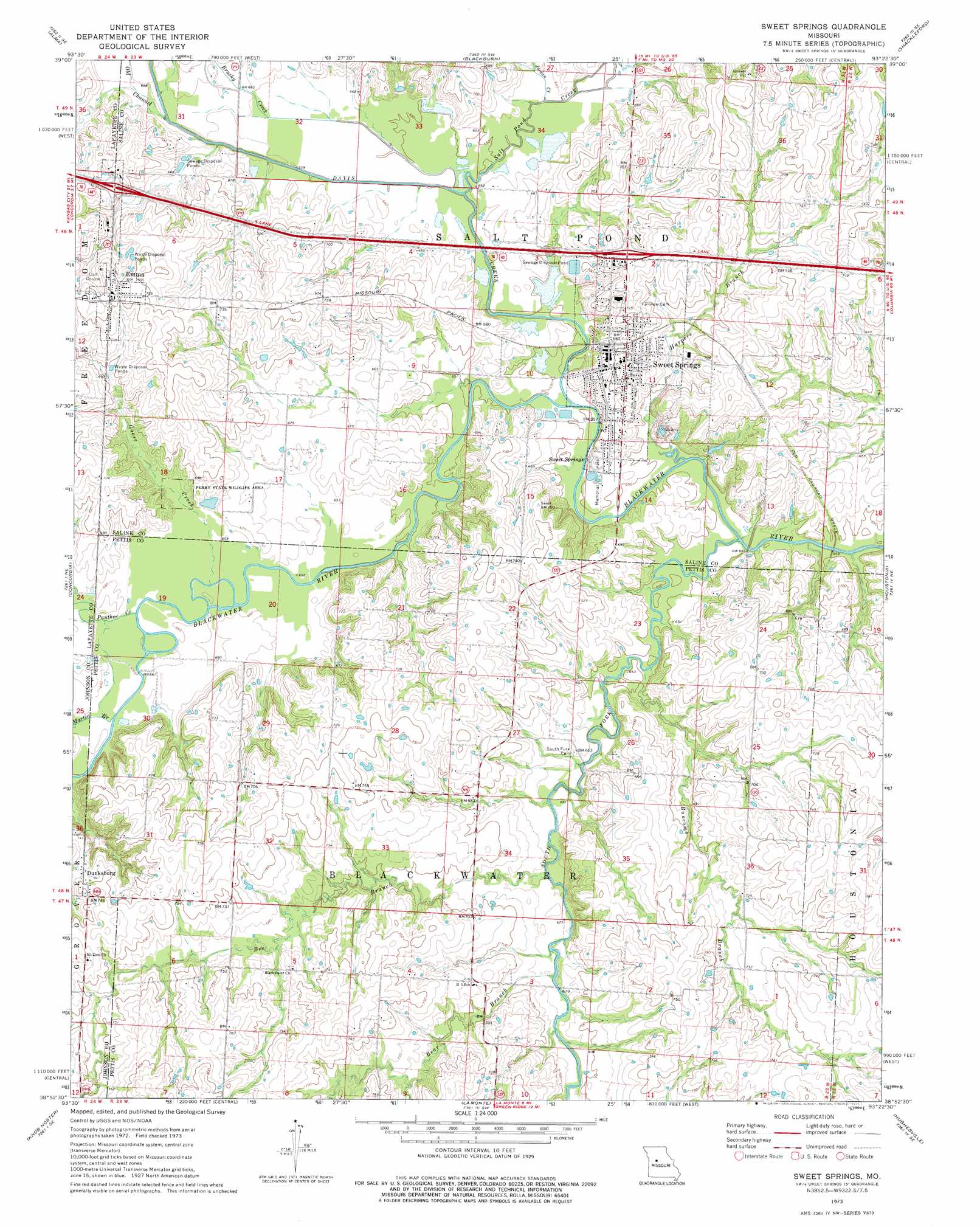
USGS Topo Quad 38093h4 - 1:24,000 scale
| Topo Map Name: | Sweet Springs |
| USGS Topo Quad ID: | 38093h4 |
| Print Size: | ca. 21 1/4" wide x 27" high |
| Southeast Coordinates: | 38.875° N latitude / 93.375° W longitude |
| Map Center Coordinates: | 38.9375° N latitude / 93.4375° W longitude |
| U.S. State: | MO |
| Filename: | o38093h4.jpg |
| Download Map JPG Image: | Sweet Springs topo map 1:24,000 scale |
| Map Type: | Topographic |
| Topo Series: | 7.5´ |
| Map Scale: | 1:24,000 |
| Source of Map Images: | United States Geological Survey (USGS) |
| Alternate Map Versions: |
Sweet Springs MO 1973, updated 1975 Download PDF Buy paper map Sweet Springs MO 2011 Download PDF Buy paper map Sweet Springs MO 2014 Download PDF Buy paper map |
1:24,000 Topo Quads surrounding Sweet Springs
Dover |
Waverly |
Grand Pass |
Malta Bend |
Marshall North |
Higginsville |
Alma |
Blackburn |
Shackleford |
Marshall South |
Knob Noster Nw |
Concordia |
Sweet Springs |
Houstonia |
Longwood |
Warrensburg East |
Knob Noster |
La Monte |
Hughesville |
Beaman |
Cornelia |
Burtville |
Green Ridge North |
Sedalia West |
Sedalia East |
> Back to 38093e1 at 1:100,000 scale
> Back to 38092a1 at 1:250,000 scale
> Back to U.S. Topo Maps home
Sweet Springs topo map: Gazetteer
Sweet Springs: Dams
City of Sweet Springs Dam A elevation 196m 643′City of Sweet Springs Dam B elevation 196m 643′
Sweet Springs: Parks
Perry State Wildlife Area elevation 200m 656′Sweet Springs: Populated Places
Dunksburg elevation 227m 744′Emma elevation 231m 757′
Sweet Springs elevation 217m 711′
Sweet Springs: Reservoirs
City Reservoir A elevation 196m 643′City Reservoir B elevation 196m 643′
Sweet Springs: Springs
Sweet Springs elevation 202m 662′Sweet Springs: Streams
Bear Branch elevation 204m 669′Bee Branch elevation 204m 669′
Brushy Creek elevation 197m 646′
Buncomb Branch elevation 196m 643′
Davis Creek elevation 195m 639′
Goose Creek elevation 198m 649′
Harpers Branch elevation 195m 639′
Jordan Creek elevation 198m 649′
Martin Branch elevation 197m 646′
Old Channel Davis Creek elevation 198m 649′
Panther Creek elevation 197m 646′
Salt Pond Creek elevation 197m 646′
South Fork Blackwater River elevation 195m 639′
Sweet Springs digital topo map on disk
Buy this Sweet Springs topo map showing relief, roads, GPS coordinates and other geographical features, as a high-resolution digital map file on DVD: