Glade Park Topo Map Colorado
To zoom in, hover over the map of Glade Park
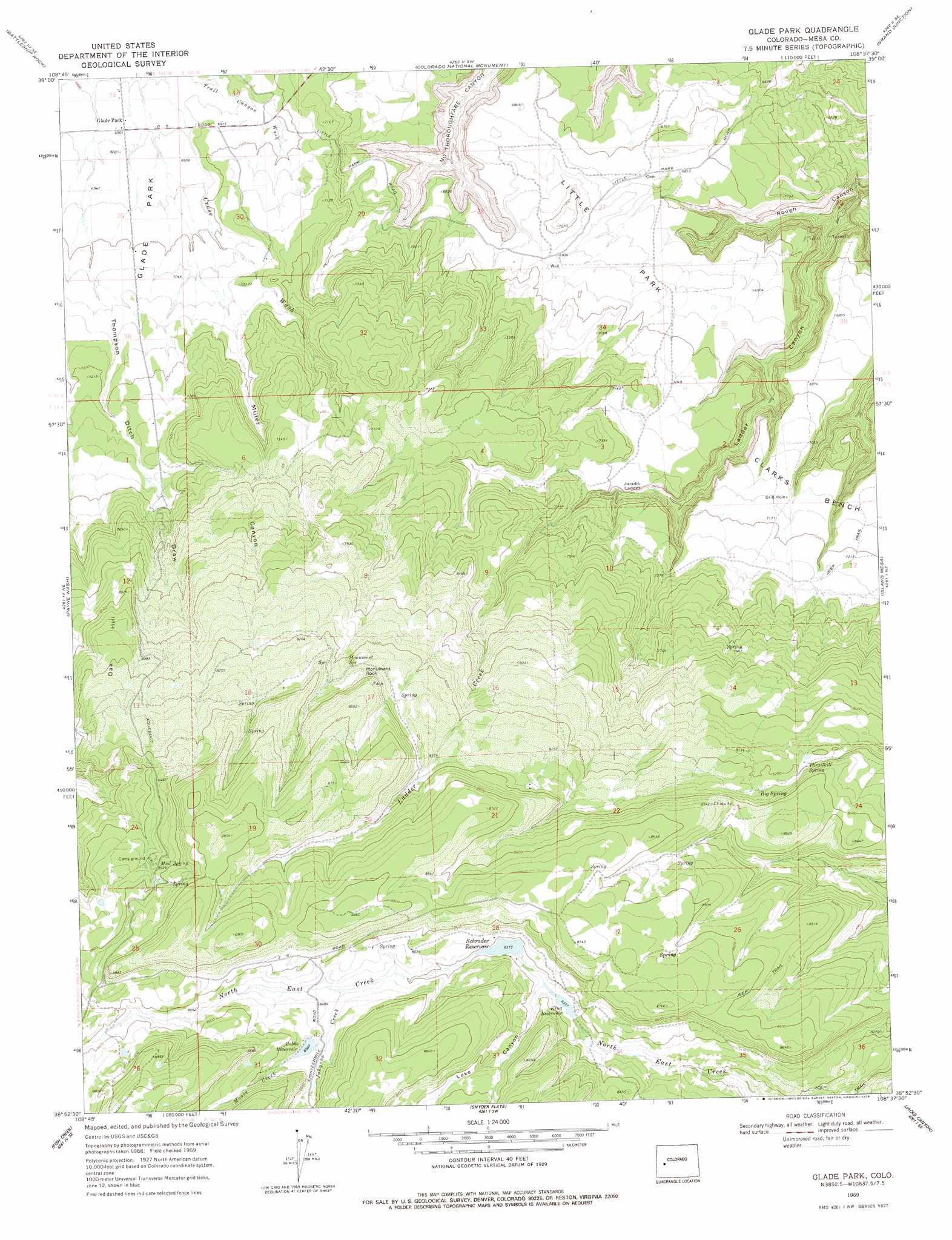
USGS Topo Quad 38108h6 - 1:24,000 scale
| Topo Map Name: | Glade Park |
| USGS Topo Quad ID: | 38108h6 |
| Print Size: | ca. 21 1/4" wide x 27" high |
| Southeast Coordinates: | 38.875° N latitude / 108.625° W longitude |
| Map Center Coordinates: | 38.9375° N latitude / 108.6875° W longitude |
| U.S. State: | CO |
| Filename: | o38108h6.jpg |
| Download Map JPG Image: | Glade Park topo map 1:24,000 scale |
| Map Type: | Topographic |
| Topo Series: | 7.5´ |
| Map Scale: | 1:24,000 |
| Source of Map Images: | United States Geological Survey (USGS) |
| Alternate Map Versions: |
Glade Park CO 1969, updated 1973 Download PDF Buy paper map Glade Park CO 1969, updated 1973 Download PDF Buy paper map Glade Park CO 1969, updated 1978 Download PDF Buy paper map Glade Park CO 2010 Download PDF Buy paper map Glade Park CO 2013 Download PDF Buy paper map Glade Park CO 2016 Download PDF Buy paper map |
1:24,000 Topo Quads surrounding Glade Park
Ruby Canyon |
Mack |
Fruita |
Corcoran Point |
Round Mountain |
Sieber Canyon |
Battleship Rock |
Colorado National Monument |
Grand Junction |
Clifton |
Bieser Creek |
Payne Wash |
Glade Park |
Island Mesa |
Whitewater |
Two V Basin |
Fish Creek |
Snyder Flats |
Jacks Canyon |
Triangle Mesa |
Gateway |
Pine Mountain |
Casto Reservoir |
Keith Creek |
Escalante Forks |
> Back to 38108e1 at 1:100,000 scale
> Back to 38108a1 at 1:250,000 scale
> Back to U.S. Topo Maps home
Glade Park topo map: Gazetteer
Glade Park: Benches
Clarks Bench elevation 2168m 7112′Glade Park: Cliffs
Jacobs Ladder elevation 2185m 7168′Glade Park: Dams
Aubert Dam elevation 2587m 8487′G H and S Number 2 Dam elevation 2553m 8375′
Gobbo Number 2 Dam elevation 2609m 8559′
Glade Park: Flats
Little Park elevation 2150m 7053′Glade Park: Populated Places
Glade Park elevation 2105m 6906′Glade Park: Reservoirs
Aubert Reservoir elevation 2587m 8487′G H and S Reservoir Number 2 elevation 2553m 8375′
Gobbo Reservoir elevation 2594m 8510′
Gobbo Reservoir Number 2 elevation 2609m 8559′
King Reservoir elevation 2542m 8339′
Schrader Reservoir elevation 2551m 8369′
Glade Park: Springs
Big Spring elevation 2513m 8244′Monument Spring elevation 2524m 8280′
Mud Spring elevation 2604m 8543′
Thrailkill Spring elevation 2497m 8192′
Glade Park: Streams
Johnson Creek elevation 2573m 8441′Moore Creek elevation 2583m 8474′
Glade Park: Summits
Monument Rock elevation 2547m 8356′Oak Hill elevation 2552m 8372′
Glade Park: Valleys
Ladder Canyon elevation 1876m 6154′Lake Canyon elevation 2544m 8346′
Miller Canyon elevation 2132m 6994′
Thompson Ditch Draw elevation 2130m 6988′
Glade Park digital topo map on disk
Buy this Glade Park topo map showing relief, roads, GPS coordinates and other geographical features, as a high-resolution digital map file on DVD: