Fish Creek Topo Map Colorado
To zoom in, hover over the map of Fish Creek
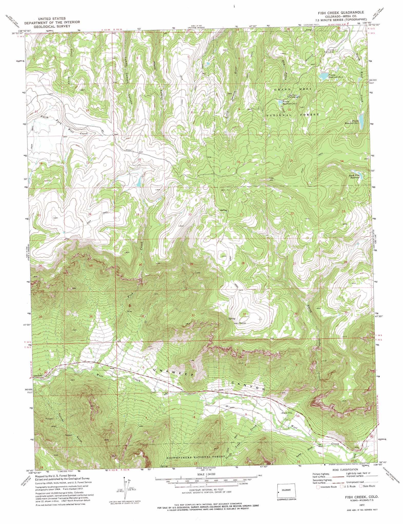
USGS Topo Quad 38108g7 - 1:24,000 scale
| Topo Map Name: | Fish Creek |
| USGS Topo Quad ID: | 38108g7 |
| Print Size: | ca. 21 1/4" wide x 27" high |
| Southeast Coordinates: | 38.75° N latitude / 108.75° W longitude |
| Map Center Coordinates: | 38.8125° N latitude / 108.8125° W longitude |
| U.S. State: | CO |
| Filename: | o38108g7.jpg |
| Download Map JPG Image: | Fish Creek topo map 1:24,000 scale |
| Map Type: | Topographic |
| Topo Series: | 7.5´ |
| Map Scale: | 1:24,000 |
| Source of Map Images: | United States Geological Survey (USGS) |
| Alternate Map Versions: |
Fish Creek CO 1972, updated 1975 Download PDF Buy paper map Fish Creek CO 2011 Download PDF Buy paper map Fish Creek CO 2013 Download PDF Buy paper map Fish Creek CO 2016 Download PDF Buy paper map |
| FStopo: | US Forest Service topo Fish Creek is available: Download FStopo PDF Download FStopo TIF |
1:24,000 Topo Quads surrounding Fish Creek
Westwater |
Sieber Canyon |
Battleship Rock |
Colorado National Monument |
Grand Junction |
Marble Canyon |
Bieser Creek |
Payne Wash |
Glade Park |
Island Mesa |
Steamboat Mesa |
Two V Basin |
Fish Creek |
Snyder Flats |
Jacks Canyon |
Dolores Point North |
Gateway |
Pine Mountain |
Casto Reservoir |
Keith Creek |
Dolores Point South |
Juanita Arch |
Calamity Mesa |
Uncompahgre Butte |
Snipe Mountain |
> Back to 38108e1 at 1:100,000 scale
> Back to 38108a1 at 1:250,000 scale
> Back to U.S. Topo Maps home
Fish Creek topo map: Gazetteer
Fish Creek: Dams
Burg Dam elevation 2731m 8959′Fruita Number 1 Dam elevation 2778m 9114′
Fruita Number 2 Dam elevation 2695m 8841′
Fruita Number 3 Dam elevation 2737m 8979′
Fish Creek: Reservoirs
Black Pine Reservoir elevation 2800m 9186′Burg Reservoir elevation 2731m 8959′
Fruita Reservoir Number 1 elevation 2788m 9146′
Fruita Reservoir Number 2 elevation 2685m 8809′
Fruita Reservoir Number 3 elevation 2737m 8979′
Fruita Waterworks Reservoir Number 1 elevation 2778m 9114′
Fruita Waterworks Reservoir Number 2 elevation 2695m 8841′
Fish Creek: Streams
Bear Creek elevation 2031m 6663′Fish Creek elevation 1932m 6338′
North Lobe Creek elevation 2011m 6597′
South Lobe Creek elevation 2011m 6597′
Fish Creek: Summits
Payne Mesa elevation 2561m 8402′Pinon Mesa elevation 2870m 9416′
Fish Creek: Valleys
Bear Canyon elevation 2038m 6686′Pansy Gulch elevation 2026m 6646′
Fish Creek digital topo map on disk
Buy this Fish Creek topo map showing relief, roads, GPS coordinates and other geographical features, as a high-resolution digital map file on DVD: