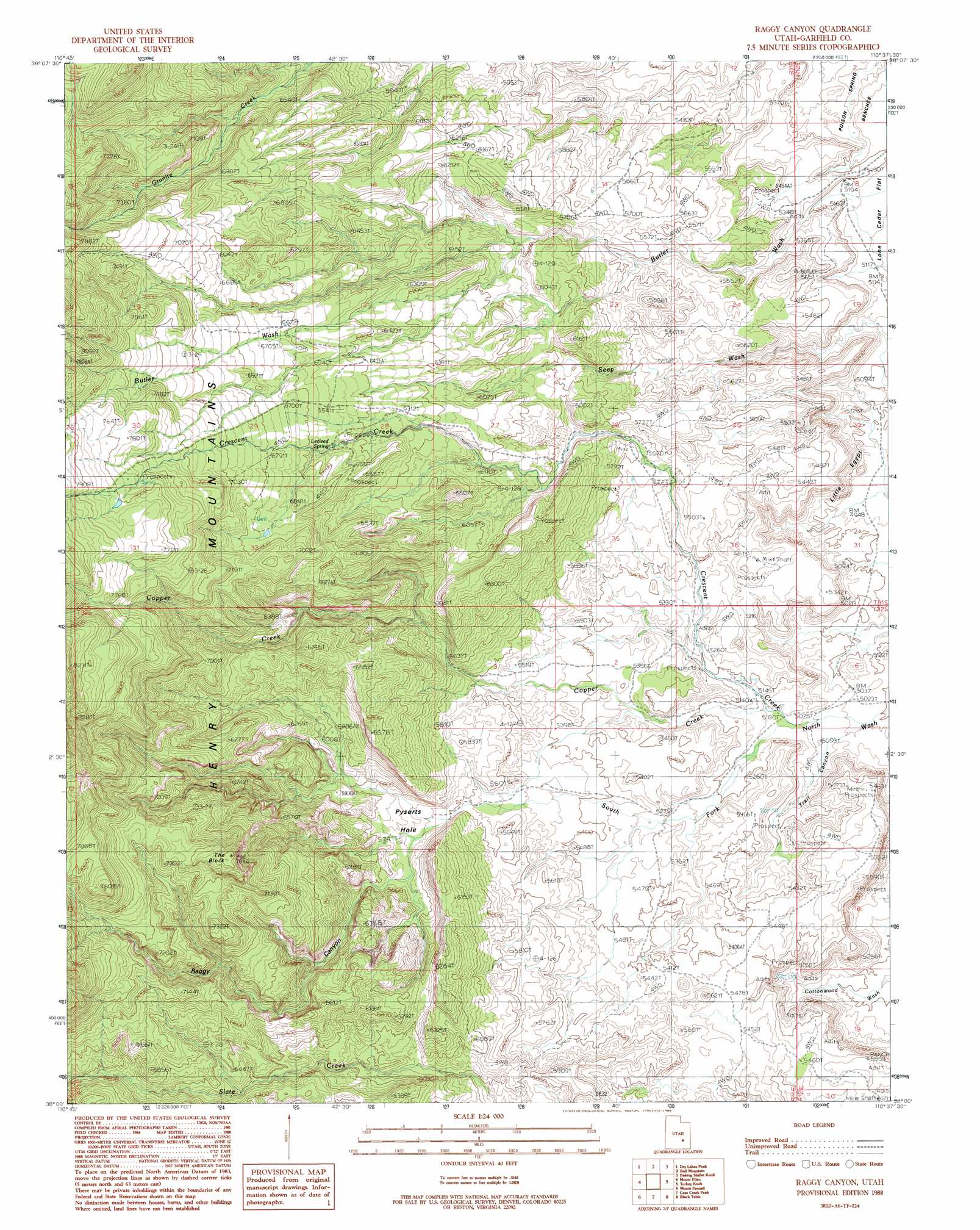
Raggy Canyon Topo Map Utah
To zoom in, hover over the map of Raggy Canyon
USGS Topo Quad 38110a6 - 1:24,000 scale
| Topo Map Name: | Raggy Canyon |
| USGS Topo Quad ID: | 38110a6 |
| Print Size: | ca. 21 1/4" wide x 27" high |
| Southeast Coordinates: | 38° N latitude / 110.625° W longitude |
| Map Center Coordinates: | 38.0625° N latitude / 110.6875° W longitude |
| U.S. State: | UT |
| Filename: | o38110a6.jpg |
| Download Map JPG Image: | Raggy Canyon topo map 1:24,000 scale |
| Map Type: | Topographic |
| Topo Series: | 7.5´ |
| Map Scale: | 1:24,000 |
| Source of Map Images: | United States Geological Survey (USGS) |
| Alternate Map Versions: |
Mount Ellen 4 SW UT 1952, updated 1954 Download PDF Buy paper map Raggy Canyon UT 1988, updated 1988 Download PDF Buy paper map Raggy Canyon UT 2010 Download PDF Buy paper map Raggy Canyon UT 2014 Download PDF Buy paper map |
1:24,000 Topo Quads surrounding Raggy Canyon
Town Point |
Steamboat Point |
Hanksville |
Angel Cove |
Angel Point |
Stevens Mesa |
Dry Lakes Peak |
Bull Mountain |
Baking Skillet Knoll |
Burr Point |
Steele Butte |
Mount Ellen |
Raggy Canyon |
Turkey Knob |
Stair Canyon |
Cave Flat |
Mount Pennell |
Cass Creek Peak |
Black Table |
Hite North |
The Post |
Ant Knoll |
Copper Creek Benches |
Mount Holmes |
Hite South |
> Back to 38110a1 at 1:100,000 scale
> Back to 38110a1 at 1:250,000 scale
> Back to U.S. Topo Maps home
Raggy Canyon topo map: Gazetteer
Raggy Canyon: Basins
Pyserts Hole elevation 1740m 5708′Raggy Canyon: Flats
Little Egypt elevation 1513m 4963′Raggy Canyon: Springs
Lecleed Spring elevation 1950m 6397′Raggy Canyon: Streams
Copper Creek elevation 1552m 5091′Crescent Creek elevation 1561m 5121′
Raggy Canyon: Summits
The Block elevation 2324m 7624′Raggy Canyon: Valleys
Raggy Canyon elevation 1742m 5715′South Fork North Wash elevation 1552m 5091′
Trail Canyon elevation 1537m 5042′
Raggy Canyon digital topo map on disk
Buy this Raggy Canyon topo map showing relief, roads, GPS coordinates and other geographical features, as a high-resolution digital map file on DVD: