Headlight Mountain Topo Map Utah
To zoom in, hover over the map of Headlight Mountain
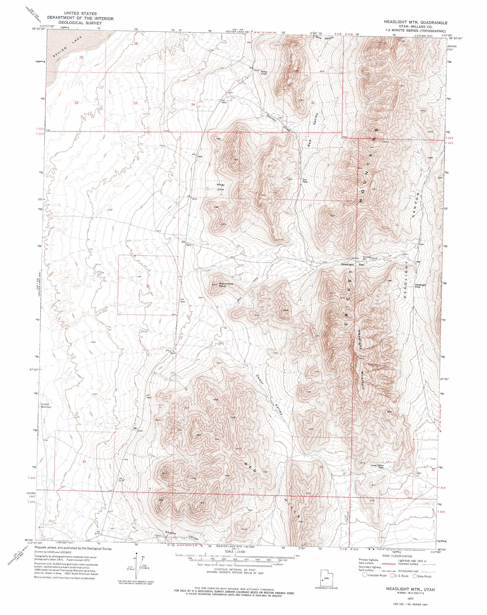
USGS Topo Quad 38113g1 - 1:24,000 scale
| Topo Map Name: | Headlight Mountain |
| USGS Topo Quad ID: | 38113g1 |
| Print Size: | ca. 21 1/4" wide x 27" high |
| Southeast Coordinates: | 38.75° N latitude / 113° W longitude |
| Map Center Coordinates: | 38.8125° N latitude / 113.0625° W longitude |
| U.S. State: | UT |
| Filename: | o38113g1.jpg |
| Download Map JPG Image: | Headlight Mountain topo map 1:24,000 scale |
| Map Type: | Topographic |
| Topo Series: | 7.5´ |
| Map Scale: | 1:24,000 |
| Source of Map Images: | United States Geological Survey (USGS) |
| Alternate Map Versions: |
Headlight Mtn UT 1972, updated 1974 Download PDF Buy paper map Headlight Mountain UT 2010 Download PDF Buy paper map Headlight Mountain UT 2014 Download PDF Buy paper map |
1:24,000 Topo Quads surrounding Headlight Mountain
Skull Rock Pass |
Long Ridge Sw |
Long Ridge Se |
Red Pass |
Neels |
Burnout Canyon |
Needle Point |
Sevier Lake Ne |
Candland Spring |
Borden |
Red Tops |
Sevier Lake Sw |
Headlight Mountain |
Cat Canyon |
Cruz |
Brown Knoll |
Iron Mine Pass |
Red Rock Knoll |
Black Rock |
Antelope Spring |
Frisco Peak |
High Rock |
Lime Mountain |
Read |
Pinnacle Pass |
> Back to 38113e1 at 1:100,000 scale
> Back to 38112a1 at 1:250,000 scale
> Back to U.S. Topo Maps home
Headlight Mountain topo map: Gazetteer
Headlight Mountain: Basins
Red Valley elevation 1625m 5331′Headlight Mountain: Cliffs
Monument Point elevation 1659m 5442′Headlight Mountain: Gaps
Cys Pass elevation 1650m 5413′Headlight Gap elevation 1651m 5416′
Headlight Pass elevation 1719m 5639′
Lone Cedar Pass elevation 1611m 5285′
Headlight Mountain: Summits
Headlight Mountain elevation 2057m 6748′Petes Knoll elevation 1557m 5108′
Red Hills elevation 1648m 5406′
Headlight Mountain: Valleys
Cedar Valley elevation 1518m 4980′Dorthy Draw elevation 1519m 4983′
Headlight Canyon elevation 1592m 5223′
Mine Canyon elevation 1619m 5311′
Shorts Valley elevation 1460m 4790′
Wingy Cove elevation 1492m 4895′
Headlight Mountain digital topo map on disk
Buy this Headlight Mountain topo map showing relief, roads, GPS coordinates and other geographical features, as a high-resolution digital map file on DVD: