Benicia Topo Map California
To zoom in, hover over the map of Benicia
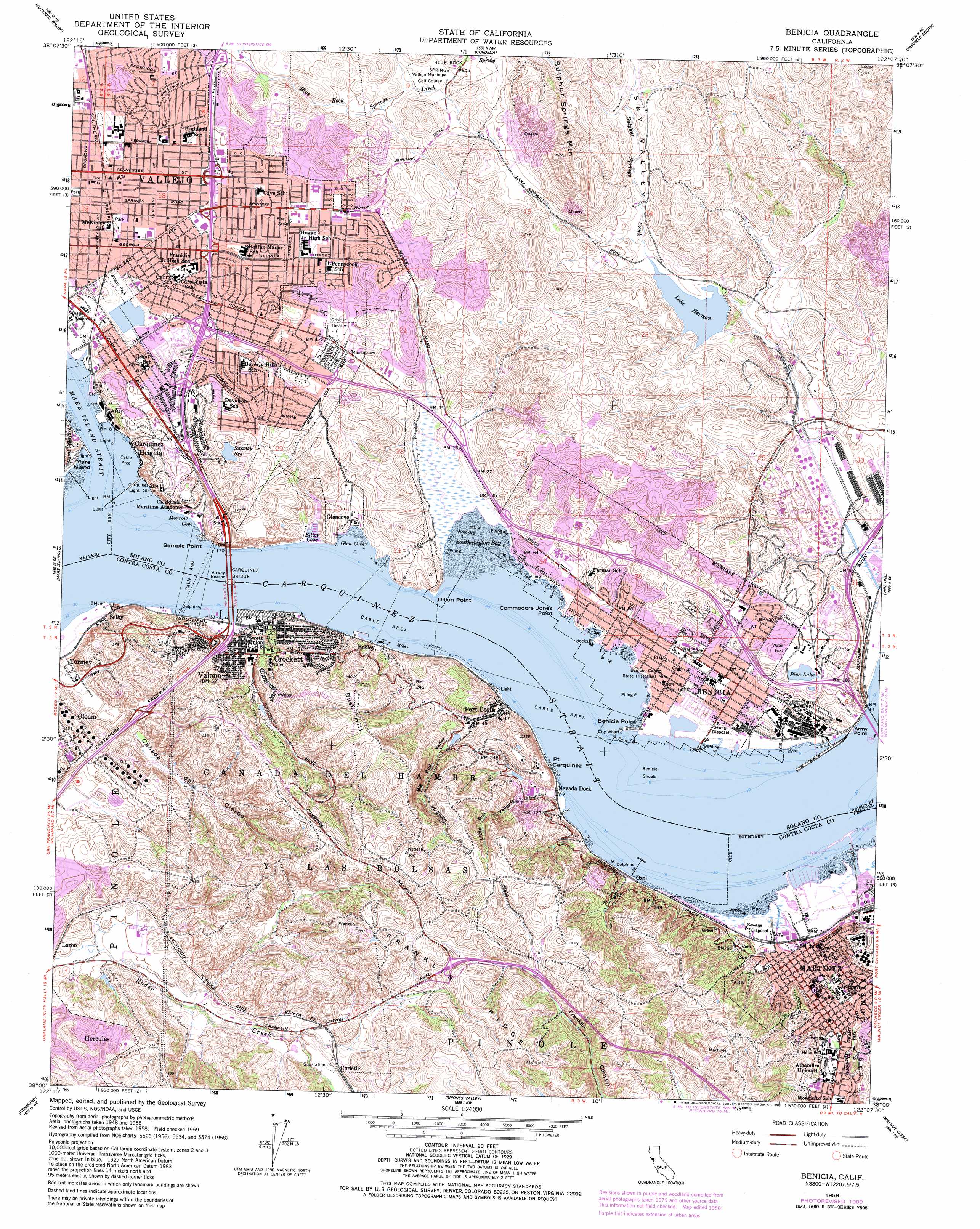
USGS Topo Quad 38122a2 - 1:24,000 scale
| Topo Map Name: | Benicia |
| USGS Topo Quad ID: | 38122a2 |
| Print Size: | ca. 21 1/4" wide x 27" high |
| Southeast Coordinates: | 38° N latitude / 122.125° W longitude |
| Map Center Coordinates: | 38.0625° N latitude / 122.1875° W longitude |
| U.S. State: | CA |
| Filename: | o38122a2.jpg |
| Download Map JPG Image: | Benicia topo map 1:24,000 scale |
| Map Type: | Topographic |
| Topo Series: | 7.5´ |
| Map Scale: | 1:24,000 |
| Source of Map Images: | United States Geological Survey (USGS) |
| Alternate Map Versions: |
Benicia CA 1950, updated 1956 Download PDF Buy paper map Benicia CA 1952 Download PDF Buy paper map Benicia CA 1959, updated 1960 Download PDF Buy paper map Benicia CA 1959, updated 1965 Download PDF Buy paper map Benicia CA 1959, updated 1969 Download PDF Buy paper map Benicia CA 1959, updated 1969 Download PDF Buy paper map Benicia CA 1959, updated 1978 Download PDF Buy paper map Benicia CA 1959, updated 1981 Download PDF Buy paper map Benicia CA 1959, updated 1981 Download PDF Buy paper map Benicia CA 1959, updated 1981 Download PDF Buy paper map Benicia CA 2012 Download PDF Buy paper map Benicia CA 2015 Download PDF Buy paper map |
1:24,000 Topo Quads surrounding Benicia
Sonoma |
Napa |
Mount George |
Fairfield North |
Elmira |
Sears Point |
Cuttings Wharf |
Cordelia |
Fairfield South |
Denverton |
Petaluma Point |
Mare Island |
Benicia |
Vine Hill |
Honker Bay |
San Quentin |
Richmond |
Briones Valley |
Walnut Creek |
Clayton |
San Francisco North |
Oakland West |
Oakland East |
Las Trampas Ridge |
Diablo |
> Back to 38122a1 at 1:100,000 scale
> Back to 38122a1 at 1:250,000 scale
> Back to U.S. Topo Maps home
Benicia topo map: Gazetteer
Benicia: Bars
Benicia Shoals elevation 0m 0′Benicia: Bays
Glen Cove elevation 0m 0′Morrow Cove elevation 0m 0′
Southhampton Bay elevation 0m 0′
Benicia: Bridges
Carquinez Bridge elevation 0m 0′Benicia: Capes
Army Point elevation 0m 0′Benicia Point elevation 2m 6′
Commodore Jones Point elevation 7m 22′
Dillon Point elevation 3m 9′
Point Carquinez elevation 5m 16′
Semple Point elevation 5m 16′
Benicia: Channels
Carquinez Strait elevation 0m 0′Suisun Point Channel elevation 0m 0′
Benicia: Crossings
Exit 26 elevation 68m 223′Exit 27 elevation 23m 75′
Exit 29A elevation 32m 104′
Exit 29B elevation 24m 78′
Exit 3A elevation 6m 19′
Exit 3B elevation 10m 32′
Exit 4 elevation 51m 167′
Exit 5 elevation 174m 570′
Exit 5 elevation 45m 147′
Exit 58A elevation 48m 157′
Exit 58B elevation 20m 65′
Exit 6 elevation 132m 433′
Exit 6 elevation 33m 108′
Exit 60 elevation 9m 29′
Exit 7 elevation 48m 157′
Benicia: Dams
Lake Herman 1028 Dam elevation 39m 127′P R D 449 Dam elevation 97m 318′
Pine Lake 1028-003 Dam elevation 47m 154′
Port Costa 1580 Dam elevation 22m 72′
Swanzy Lake 14-005 Dam elevation 80m 262′
Benicia: Harbors
Elliot Cove elevation 0m 0′Benicia: Parks
Alexander Park elevation 12m 39′Amador Park elevation 7m 22′
Benicia Capitol State Historic Park elevation 8m 26′
Benicia State Recreation Area elevation 2m 6′
Beverly Hills Park elevation 55m 180′
Blue Rock Springs Park elevation 92m 301′
Carquinez Strait Regional Shoreline elevation 93m 305′
Castlewood Park elevation 19m 62′
Duncan Graham Park elevation 57m 187′
Fairmont Park elevation 32m 104′
Fitzgerald Field elevation 4m 13′
Francesca Terrace Park elevation 50m 164′
Glen Cove Park elevation 25m 82′
Glen Cove Waterfront Park elevation 8m 26′
Grant Mahoney Park elevation 16m 52′
Hanns Park elevation 81m 265′
Highlands Park elevation 40m 131′
Jensen Park elevation 16m 52′
Lake Dalwigk Park elevation 6m 19′
Maria Field elevation 5m 16′
Martinez Municipal Park elevation 45m 147′
Martinez Regional Shoreline Park elevation 2m 6′
Martinez Waterfront Park elevation 4m 13′
Ninth Street Park elevation 8m 26′
Overlook Park elevation 101m 331′
Plaza Del Hambre elevation 10m 32′
Ribiero Field elevation 5m 16′
Ricks Memorial Park elevation 13m 42′
Rithel Park elevation 7m 22′
Saint Pauls Square elevation 12m 39′
Southampton Park elevation 102m 334′
Susana Park elevation 8m 26′
Twelfth Street Park elevation 8m 26′
Vallejo Old City Historic District elevation 25m 82′
Willow Park elevation 13m 42′
Wilson Park elevation 3m 9′
Woodhill Park elevation 75m 246′
Benicia: Populated Places
Benicia elevation 8m 26′Carquinez Heights elevation 3m 9′
Christie elevation 89m 291′
Crockett elevation 39m 127′
Crolona Heights elevation 27m 88′
Eckley elevation 3m 9′
Glencove elevation 6m 19′
Martinez elevation 7m 22′
Oleum elevation 62m 203′
Ozol elevation 2m 6′
Port Costa elevation 5m 16′
Selby elevation 6m 19′
South Vallejo elevation 13m 42′
Sulphur Springs (historical) elevation 103m 337′
Tormey elevation 6m 19′
Valona elevation 19m 62′
Benicia: Post Offices
Benicia Post Office elevation 14m 45′Crockett Post Office elevation 6m 19′
Port Costa Post Office elevation 4m 13′
Benicia: Reservoirs
Lake Dalwigk elevation -4m -14′Lake Herman elevation 37m 121′
Pine Lake elevation 47m 154′
Puddy Lake elevation 64m 209′
Selby Reservoir elevation 87m 285′
Swanzy Reservoir elevation 82m 269′
Benicia: Ridges
Franklin Ridge elevation 280m 918′Benicia: Streams
Arroyo del Hambre elevation 2m 6′Napa River elevation 0m 0′
Benicia: Summits
Bush Hill elevation 208m 682′Benicia: Valleys
Alhambra Valley elevation 7m 22′Big Bull Valley elevation 0m 0′
Cañada Del Cierbo elevation 27m 88′
Little Bull Valley elevation 2m 6′
Sky Valley elevation 40m 131′
Benicia digital topo map on disk
Buy this Benicia topo map showing relief, roads, GPS coordinates and other geographical features, as a high-resolution digital map file on DVD: