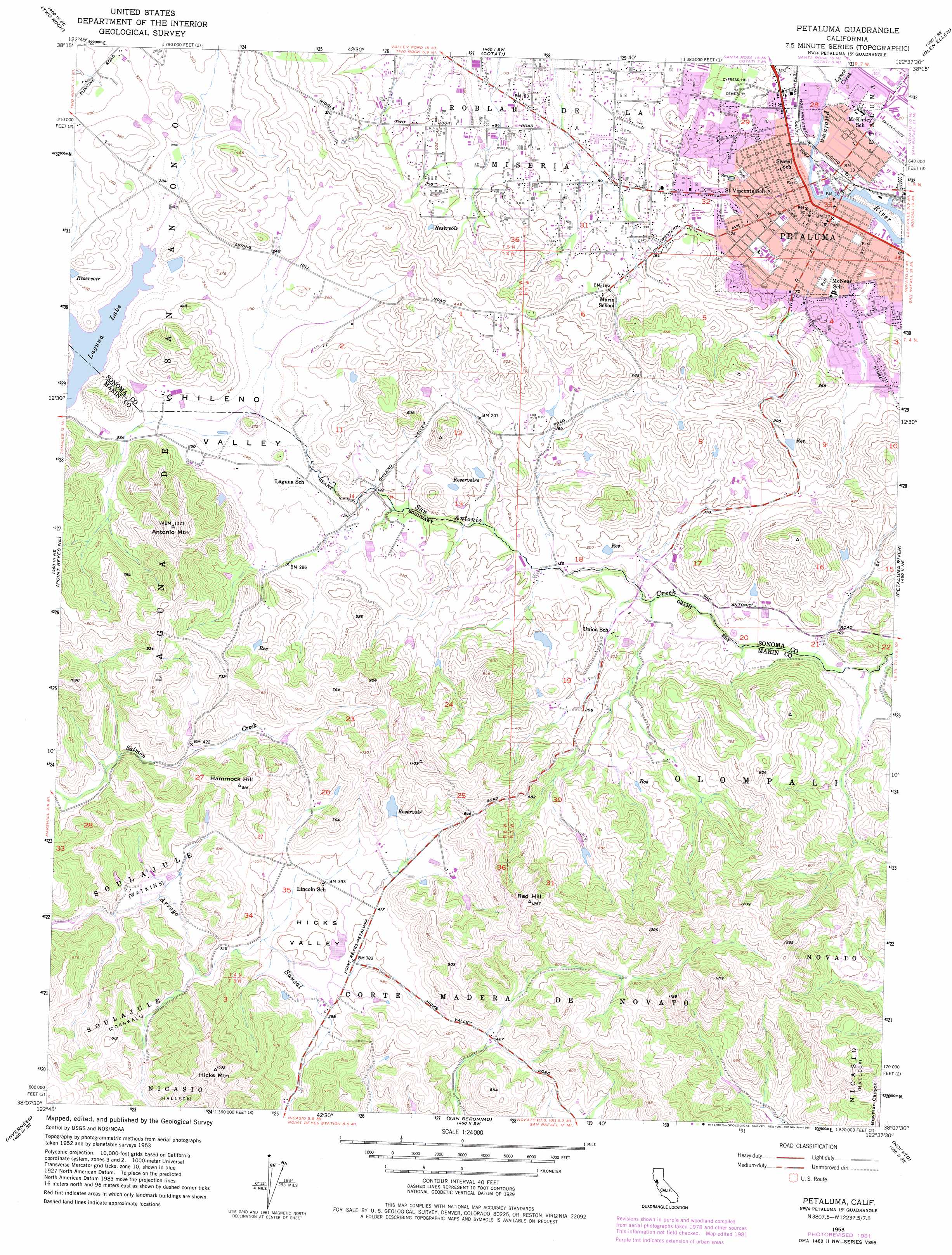
Petaluma Topo Map California
To zoom in, hover over the map of Petaluma
USGS Topo Quad 38122b6 - 1:24,000 scale
| Topo Map Name: | Petaluma |
| USGS Topo Quad ID: | 38122b6 |
| Print Size: | ca. 21 1/4" wide x 27" high |
| Southeast Coordinates: | 38.125° N latitude / 122.625° W longitude |
| Map Center Coordinates: | 38.1875° N latitude / 122.6875° W longitude |
| U.S. State: | CA |
| Filename: | o38122b6.jpg |
| Download Map JPG Image: | Petaluma topo map 1:24,000 scale |
| Map Type: | Topographic |
| Topo Series: | 7.5´ |
| Map Scale: | 1:24,000 |
| Source of Map Images: | United States Geological Survey (USGS) |
| Alternate Map Versions: |
Petaluma CA 1953, updated 1955 Download PDF Buy paper map Petaluma CA 1953, updated 1964 Download PDF Buy paper map Petaluma CA 1953, updated 1981 Download PDF Buy paper map Petaluma CA 1954, updated 1969 Download PDF Buy paper map Petaluma CA 2012 Download PDF Buy paper map Petaluma CA 2015 Download PDF Buy paper map |
1:24,000 Topo Quads surrounding Petaluma
Camp Meeker |
Sebastopol |
Santa Rosa |
Kenwood |
Rutherford |
Valley Ford |
Two Rock |
Cotati |
Glen Ellen |
Sonoma |
Tomales |
Point Reyes Ne |
Petaluma |
Petaluma River |
Sears Point |
Drakes Bay |
Inverness |
San Geronimo |
Novato |
Petaluma Point |
Double Point |
Bolinas |
San Rafael |
San Quentin |
> Back to 38122a1 at 1:100,000 scale
> Back to 38122a1 at 1:250,000 scale
> Back to U.S. Topo Maps home
Petaluma topo map: Gazetteer
Petaluma: Basins
Hicks Valley elevation 123m 403′Petaluma: Capes
McNear Peninsula elevation 12m 39′Petaluma: Channels
McNear Channel elevation 6m 19′Petaluma: Dams
Dolcini 431 Dam elevation 161m 528′Vonsen 430 Dam elevation 75m 246′
Petaluma: Lakes
Laguna Lake elevation 69m 226′Petaluma: Parks
Cherry Valley Park elevation 36m 118′Helen Putnam Regional Park elevation 146m 479′
Hill Plaza Park elevation 13m 42′
Kenilworth Park elevation 6m 19′
Liberty Park elevation 9m 29′
McNear Park elevation 12m 39′
Oak Hill Park elevation 46m 150′
Petaluma Swim Center elevation 13m 42′
Putman Plaza Park elevation 9m 29′
Shollenberger Park elevation 12m 39′
Walnut Park elevation 9m 29′
Wickersham Park elevation 10m 32′
Petaluma: Populated Places
East Petaluma elevation 13m 42′Petaluma elevation 9m 29′
Petaluma: Post Offices
Petaluma Post Office elevation 9m 29′Petaluma: Streams
Lynch Creek elevation 9m 29′Petaluma: Summits
Antonio Mountain elevation 356m 1167′Hammock Hill elevation 276m 905′
Hicks Mountain elevation 467m 1532′
Red Hill elevation 376m 1233′
Petaluma digital topo map on disk
Buy this Petaluma topo map showing relief, roads, GPS coordinates and other geographical features, as a high-resolution digital map file on DVD: