Yountville Topo Map California
To zoom in, hover over the map of Yountville
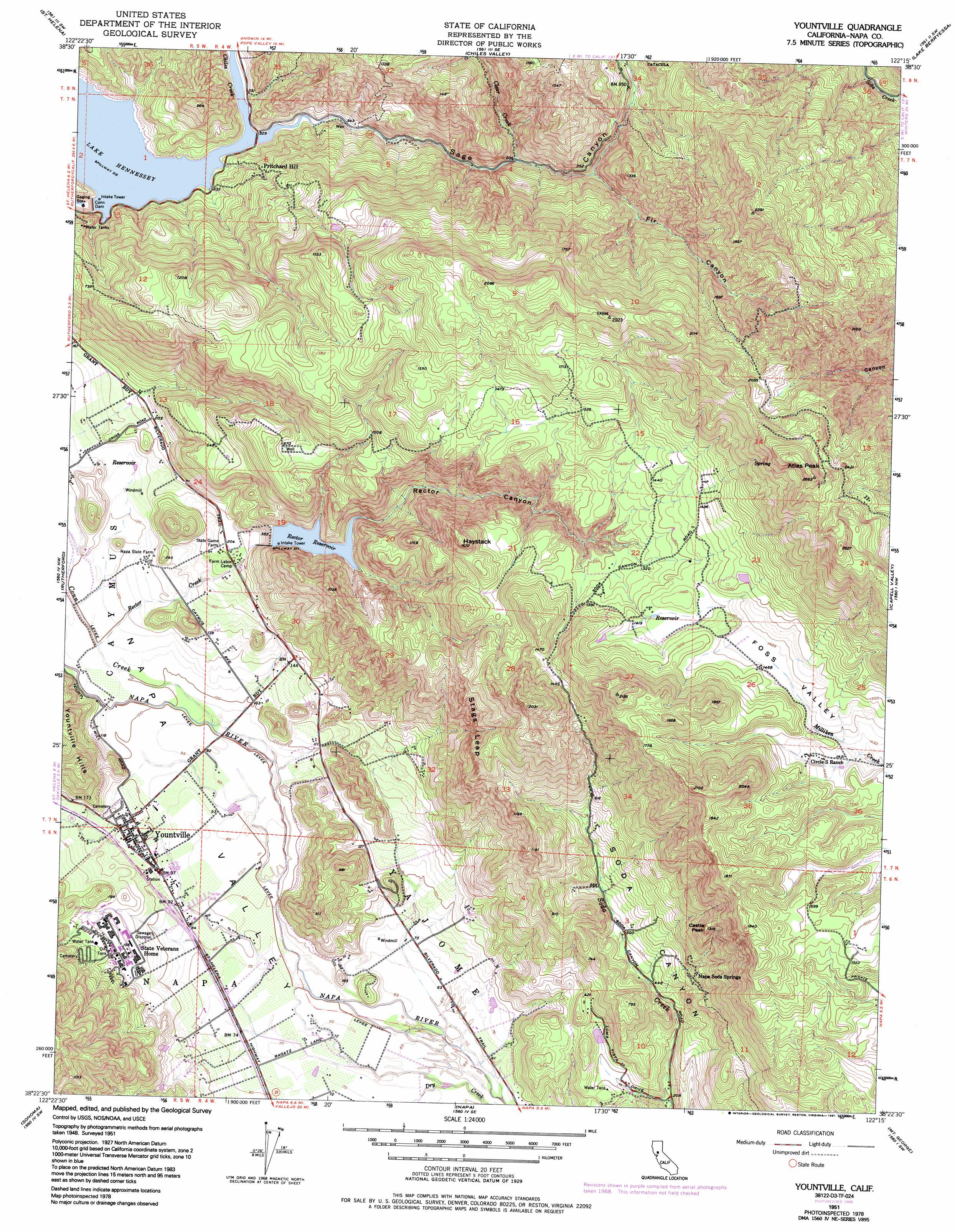
USGS Topo Quad 38122d3 - 1:24,000 scale
| Topo Map Name: | Yountville |
| USGS Topo Quad ID: | 38122d3 |
| Print Size: | ca. 21 1/4" wide x 27" high |
| Southeast Coordinates: | 38.375° N latitude / 122.25° W longitude |
| Map Center Coordinates: | 38.4375° N latitude / 122.3125° W longitude |
| U.S. State: | CA |
| Filename: | o38122d3.jpg |
| Download Map JPG Image: | Yountville topo map 1:24,000 scale |
| Map Type: | Topographic |
| Topo Series: | 7.5´ |
| Map Scale: | 1:24,000 |
| Source of Map Images: | United States Geological Survey (USGS) |
| Alternate Map Versions: |
Yountville CA 1951, updated 1952 Download PDF Buy paper map Yountville CA 1951, updated 1960 Download PDF Buy paper map Yountville CA 1951, updated 1966 Download PDF Buy paper map Yountville CA 1951, updated 1969 Download PDF Buy paper map Yountville CA 1951, updated 1984 Download PDF Buy paper map Yountville CA 1951, updated 1991 Download PDF Buy paper map Yountville CA 2012 Download PDF Buy paper map Yountville CA 2015 Download PDF Buy paper map |
1:24,000 Topo Quads surrounding Yountville
Detert Reservoir |
Aetna Springs |
Walter Springs |
Brooks |
Esparto |
Calistoga |
Saint Helena |
Chiles Valley |
Lake Berryessa |
Monticello Dam |
Kenwood |
Rutherford |
Yountville |
Capell Valley |
Mount Vaca |
Glen Ellen |
Sonoma |
Napa |
Mount George |
Fairfield North |
Petaluma River |
Sears Point |
Cuttings Wharf |
Cordelia |
Fairfield South |
> Back to 38122a1 at 1:100,000 scale
> Back to 38122a1 at 1:250,000 scale
> Back to U.S. Topo Maps home
Yountville topo map: Gazetteer
Yountville: Cliffs
Stags Leap elevation 296m 971′Yountville: Dams
Circle S 2417 Dam elevation 447m 1466′Conn Dam elevation 98m 321′
Rector Creek 1-0 1 Dam elevation 115m 377′
Yountville: Populated Places
Caymus (historical) elevation 32m 104′Napa Soda Springs elevation 215m 705′
Yountville elevation 30m 98′
Yountville: Post Offices
Veterans Home Post Office elevation 43m 141′Yountville Post Office elevation 33m 108′
Yountville: Reservoirs
Lake Hennessey elevation 98m 321′Rector Reservoir elevation 115m 377′
Yountville: Streams
Chiles Creek elevation 97m 318′Clear Creek elevation 159m 521′
Conn Creek elevation 28m 91′
Hopper Creek elevation 19m 62′
Rector Creek elevation 33m 108′
Sage Creek elevation 97m 318′
Yountville: Summits
Atlas Peak elevation 814m 2670′Castle Peak elevation 392m 1286′
Haystack elevation 474m 1555′
Yountville: Valleys
Fir Canyon elevation 191m 626′Rector Canyon elevation 68m 223′
Sage Canyon elevation 97m 318′
Yountville digital topo map on disk
Buy this Yountville topo map showing relief, roads, GPS coordinates and other geographical features, as a high-resolution digital map file on DVD: