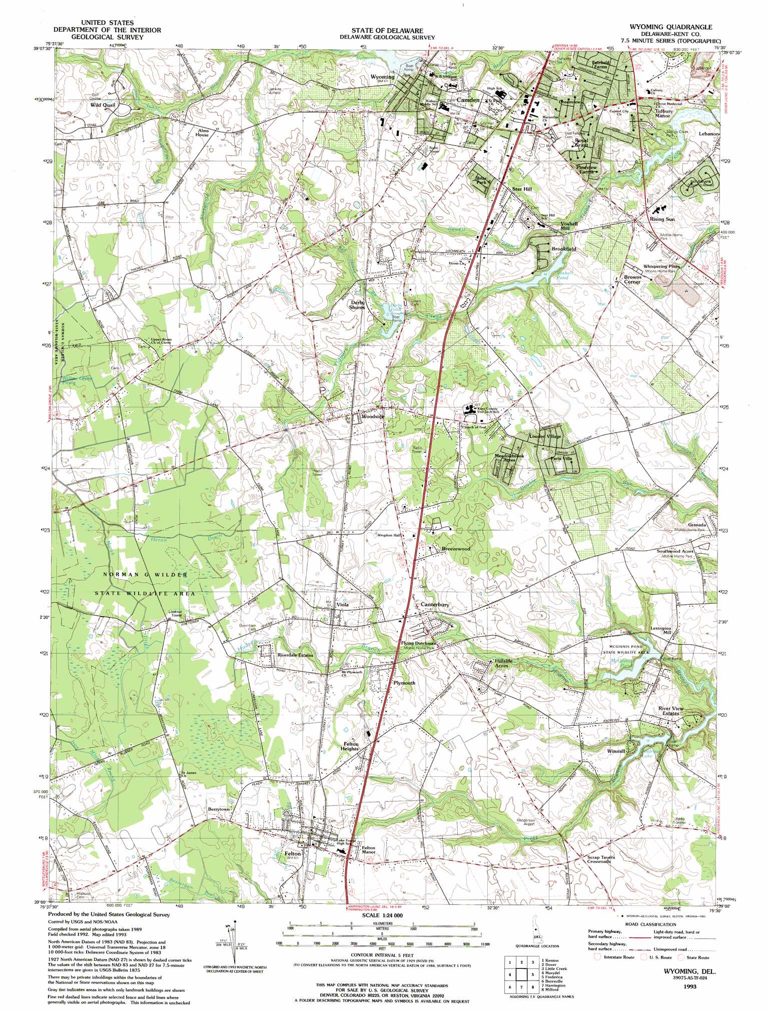
Wyoming Topo Map Delaware
To zoom in, hover over the map of Wyoming
USGS Topo Quad 39075a5 - 1:24,000 scale
| Topo Map Name: | Wyoming |
| USGS Topo Quad ID: | 39075a5 |
| Print Size: | ca. 21 1/4" wide x 27" high |
| Southeast Coordinates: | 39° N latitude / 75.5° W longitude |
| Map Center Coordinates: | 39.0625° N latitude / 75.5625° W longitude |
| U.S. State: | DE |
| Filename: | o39075a5.jpg |
| Download Map JPG Image: | Wyoming topo map 1:24,000 scale |
| Map Type: | Topographic |
| Topo Series: | 7.5´ |
| Map Scale: | 1:24,000 |
| Source of Map Images: | United States Geological Survey (USGS) |
| Alternate Map Versions: |
Wyoming DE 1956, updated 1957 Download PDF Buy paper map Wyoming DE 1956, updated 1973 Download PDF Buy paper map Wyoming DE 1956, updated 1982 Download PDF Buy paper map Wyoming DE 1993, updated 1993 Download PDF Buy paper map Wyoming DE 2011 Download PDF Buy paper map Wyoming DE 2014 Download PDF Buy paper map Wyoming DE 2016 Download PDF Buy paper map |
1:24,000 Topo Quads surrounding Wyoming
Millington |
Clayton |
Smyrna |
Bombay Hook |
Ben Davis Point |
Sudlersville |
Kenton |
Dover |
Little Creek |
|
Goldsboro |
Marydel |
Wyoming |
Frederica |
Bennetts Pier |
Denton |
Burrsville |
Harrington |
Milford |
Mispillion River |
Hobbs |
Hickman |
Greenwood |
Ellendale |
Milton |
> Back to 39075a1 at 1:100,000 scale
> Back to 39074a1 at 1:250,000 scale
> Back to U.S. Topo Maps home
Wyoming topo map: Gazetteer
Wyoming: Airports
Jenkins Airfield elevation 12m 39′Yorde Aviation Airport elevation 13m 42′
Wyoming: Areas
Golden Thicket (historical) elevation 19m 62′Wyoming: Bridges
Clarence Vinson Bridge elevation 12m 39′Wyoming: Canals
Cow Marsh Ditch elevation 17m 55′Wyoming: Dams
Derby Pond Dam elevation 10m 32′McGinnis Pond Dam elevation 4m 13′
Voshell Mill Pond Dam elevation 5m 16′
Wyoming Lake Dam elevation 9m 29′
Wyoming: Lakes
Howell Pond elevation 6m 19′Wyoming: Parks
Breck Nock Park elevation 10m 32′Great Geneva elevation 11m 36′
Johnson Square Park elevation 9m 29′
Tidbury Park elevation 3m 9′
Wyoming: Populated Places
Alexanders Village elevation 13m 42′Allee elevation 14m 45′
Andrews Lake Estates elevation 11m 36′
Barclay Farms elevation 16m 52′
Beades Estate elevation 13m 42′
Berrytown elevation 18m 59′
Bork Acres elevation 15m 49′
Breezewood elevation 16m 52′
Briar Park elevation 14m 45′
Brookfield elevation 8m 26′
Browns Corner elevation 14m 45′
Burwood elevation 13m 42′
Burwood Farms elevation 13m 42′
Camden elevation 12m 39′
Candlewicke elevation 10m 32′
Canterbury elevation 17m 55′
Canterbury Trails elevation 16m 52′
Canterville elevation 18m 59′
Carriage Lane elevation 7m 22′
Carter Development elevation 12m 39′
Chaplecroft elevation 11m 36′
Chimney Hill elevation 17m 55′
Del Haven Estates elevation 11m 36′
Del Haven Estates elevation 10m 32′
Derby Shores elevation 16m 52′
Derbywood elevation 13m 42′
Eagles Nest elevation 12m 39′
Fairfield Farms elevation 10m 32′
Felton elevation 17m 55′
Felton Heights elevation 18m 59′
Felton Manor elevation 21m 68′
Felton Station elevation 18m 59′
Forest Landing elevation 6m 19′
Garton Development elevation 15m 49′
Granada Mobile Home Park elevation 12m 39′
Green Acres Mobile Home Park elevation 13m 42′
Greenview elevation 13m 42′
Harrison Knoll elevation 14m 45′
Hidden Pond elevation 18m 59′
Highland Acres elevation 11m 36′
Hillside Acres elevation 15m 49′
Hudson Trails elevation 14m 45′
Lakewind elevation 13m 42′
Lakewind III elevation 14m 45′
Lebanon elevation 6m 19′
Lexington Mill elevation 9m 29′
London Village elevation 15m 49′
Lone Star Mobile Home Park elevation 13m 42′
Markeys Mobile Home Park elevation 10m 32′
Meadow Glen elevation 12m 39′
Meadowbrook Acres elevation 14m 45′
Melbourne Manor elevation 18m 59′
Mifflin Meadows elevation 11m 36′
Newell Creek elevation 13m 42′
Normansmeade elevation 15m 49′
Oaknoll elevation 18m 59′
Orchard Acres elevation 16m 52′
Oxyoke Mobile Home Park elevation 16m 52′
Palmer Park elevation 10m 32′
Paris Villa elevation 13m 42′
Pennwood elevation 10m 32′
Pharsalia elevation 11m 36′
Pickwick Acres elevation 14m 45′
Pleasant Hill elevation 8m 26′
Plymouth elevation 18m 59′
Richardson Estates elevation 9m 29′
Rising Sun elevation 10m 32′
Rising Sun Mobile Home Park elevation 12m 39′
Riverdale Estates Mobile Home Park elevation 18m 59′
Riverview elevation 9m 29′
Rockland Hills elevation 19m 62′
Royal Grant elevation 10m 32′
Scrap Tavern Crossroads elevation 14m 45′
Shady Lane elevation 9m 29′
Southwood Acres Mobile Home Park elevation 12m 39′
Star Hill elevation 12m 39′
Star Hill Village elevation 10m 32′
Summerfield Village elevation 18m 59′
The Blades elevation 13m 42′
The Flying Dutchman Mobile Home Park elevation 12m 39′
The Orchard elevation 12m 39′
The Village at Wild Quail elevation 18m 59′
Tidbury Creek Park Mobile Home Park elevation 9m 29′
Tidbury Manor elevation 7m 22′
Townsend Fields elevation 11m 36′
Turnkey elevation 10m 32′
Village at Chestnut Ridge elevation 14m 45′
Viola elevation 18m 59′
Viola Woods elevation 17m 55′
Voshell Mill elevation 5m 16′
Whispering Pines Mobile Home Park elevation 13m 42′
White Hall elevation 18m 59′
Winmill elevation 11m 36′
Winmill elevation 12m 39′
Woodbury elevation 12m 39′
Wooden Bridge elevation 10m 32′
Woodfield elevation 16m 52′
Woodside elevation 17m 55′
Wynn Wood elevation 17m 55′
Wyoming elevation 13m 42′
Wyoming Mills elevation 11m 36′
Wyoming: Post Offices
Camden Wyoming Post Office elevation 12m 39′Felton Post Office elevation 18m 59′
Viola Post Office elevation 18m 59′
Woodside Post Office elevation 17m 55′
Wyoming: Reservoirs
Andrews Lake elevation 4m 13′Derby Pond elevation 10m 32′
McGinnis Pond elevation 4m 13′
Voshell Pond elevation 5m 16′
Wyoming Lake elevation 9m 29′
Wyoming: Streams
Allabands Mill Stream elevation 12m 39′Almshouse Branch elevation 10m 32′
Heron Drain elevation 15m 49′
Newell Branch elevation 4m 13′
Red House Branch elevation 10m 32′
Wyoming digital topo map on disk
Buy this Wyoming topo map showing relief, roads, GPS coordinates and other geographical features, as a high-resolution digital map file on DVD:
Atlantic Coast (NY, NJ, PA, DE, MD, VA, NC)
Buy digital topo maps: Atlantic Coast (NY, NJ, PA, DE, MD, VA, NC)
 map DVD")