Lancaster Topo Map Ohio
To zoom in, hover over the map of Lancaster
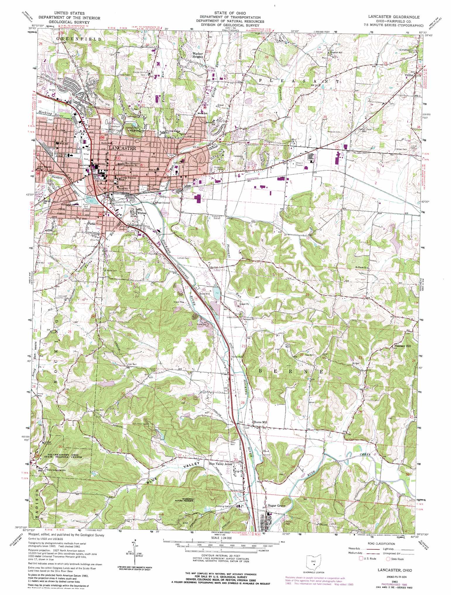
USGS Topo Quad 39082f5 - 1:24,000 scale
| Topo Map Name: | Lancaster |
| USGS Topo Quad ID: | 39082f5 |
| Print Size: | ca. 21 1/4" wide x 27" high |
| Southeast Coordinates: | 39.625° N latitude / 82.5° W longitude |
| Map Center Coordinates: | 39.6875° N latitude / 82.5625° W longitude |
| U.S. State: | OH |
| Filename: | o39082f5.jpg |
| Download Map JPG Image: | Lancaster topo map 1:24,000 scale |
| Map Type: | Topographic |
| Topo Series: | 7.5´ |
| Map Scale: | 1:24,000 |
| Source of Map Images: | United States Geological Survey (USGS) |
| Alternate Map Versions: |
Lancaster OH 1961, updated 1963 Download PDF Buy paper map Lancaster OH 1961, updated 1969 Download PDF Buy paper map Lancaster OH 1961, updated 1976 Download PDF Buy paper map Lancaster OH 1961, updated 1985 Download PDF Buy paper map Lancaster OH 2010 Download PDF Buy paper map Lancaster OH 2013 Download PDF Buy paper map Lancaster OH 2016 Download PDF Buy paper map |
1:24,000 Topo Quads surrounding Lancaster
Reynoldsburg |
Pataskala |
Millersport |
Thornville |
Glenford |
Canal Winchester |
Carroll |
Baltimore |
Rushville |
Somerset |
East Ringgold |
Amanda |
Lancaster |
Bremen |
Junction City |
Stoutsville |
Clearport |
Rockbridge |
Logan |
Gore |
Hallsville |
Laurelville |
South Bloomingville |
New Plymouth |
Union Furnace |
> Back to 39082e1 at 1:100,000 scale
> Back to 39082a1 at 1:250,000 scale
> Back to U.S. Topo Maps home
Lancaster topo map: Gazetteer
Lancaster: Airports
Deeds Field elevation 243m 797′Lancaster: Bridges
Hummell Bridge elevation 233m 764′Wheeling Street Bridge elevation 247m 810′
Lancaster: Dams
Boka Woods Number One Dam elevation 296m 971′Pine Lake Estates Dam elevation 259m 849′
Rush Creek Conservation District Structure 7d Dam elevation 256m 839′
Lancaster: Parks
Alley Park elevation 247m 810′Burnham Park elevation 247m 810′
Cenci Lake Park elevation 246m 807′
Deffenbaugh Park elevation 251m 823′
Elmwood Park elevation 249m 816′
Firehouse Park elevation 268m 879′
Glassco Park elevation 252m 826′
Hocking Park elevation 250m 820′
Huffer Durdin Park elevation 260m 853′
Hunter Park elevation 255m 836′
Lancaster Historic District elevation 266m 872′
Lancaster West Main Street Historic District elevation 255m 836′
Lanreco Park elevation 249m 816′
Maher Park elevation 247m 810′
Miller Park elevation 249m 816′
North Field elevation 252m 826′
Olivedale Park elevation 257m 843′
Rising Park elevation 269m 882′
Sherman House State Memorial elevation 265m 869′
Square 13 Historic District elevation 268m 879′
Utica Park elevation 259m 849′
Wacker Park elevation 275m 902′
Wahkeena Nature Preserve elevation 248m 813′
Zane Park elevation 256m 839′
Lancaster: Populated Places
Blue Valley Acres elevation 234m 767′Brookdale Mobile Home Park elevation 243m 797′
Carpenters Addition elevation 252m 826′
Colfax elevation 304m 997′
Colony Village Mobile Home Park elevation 243m 797′
Horns Mill elevation 243m 797′
Lancaster elevation 268m 879′
Lancaster Mobile Estates elevation 254m 833′
Pine Lake Estates elevation 268m 879′
Pleasant Hill elevation 312m 1023′
Rest-over Trailer Park elevation 240m 787′
Rustic Ridge Manufactured Housing Community elevation 246m 807′
Sandstone (historical) elevation 253m 830′
Sugar Grove elevation 238m 780′
Tarhe Town (historical) elevation 251m 823′
Taylor Mobile Home Park elevation 249m 816′
Wacker Heights elevation 301m 987′
Whites elevation 251m 823′
Yogi's Mobile Home Park elevation 238m 780′
Lancaster: Post Offices
Colfax Post Office (historical) elevation 305m 1000′Lancaster Post Office elevation 255m 836′
Sugar Grove Post Office elevation 238m 780′
Lancaster: Reservoirs
Boka Woods Number One Reservoir elevation 296m 971′Pine Lake elevation 259m 849′
Rush Creek Conservation District Structure Reservoir elevation 256m 839′
Lancaster: Streams
Baldwin Run elevation 244m 800′Ewing Run elevation 249m 816′
Fetters Run elevation 249m 816′
Hunters Run elevation 247m 810′
Pleasant Run elevation 238m 780′
Tarhe Run elevation 247m 810′
Lancaster: Summits
Main Hill elevation 268m 879′Mount Pleasant elevation 331m 1085′
Waterworks Hill elevation 335m 1099′
Lancaster: Valleys
Blue Valley elevation 231m 757′Lancaster digital topo map on disk
Buy this Lancaster topo map showing relief, roads, GPS coordinates and other geographical features, as a high-resolution digital map file on DVD:
 map DVD")