Dotsero Topo Map Colorado
To zoom in, hover over the map of Dotsero
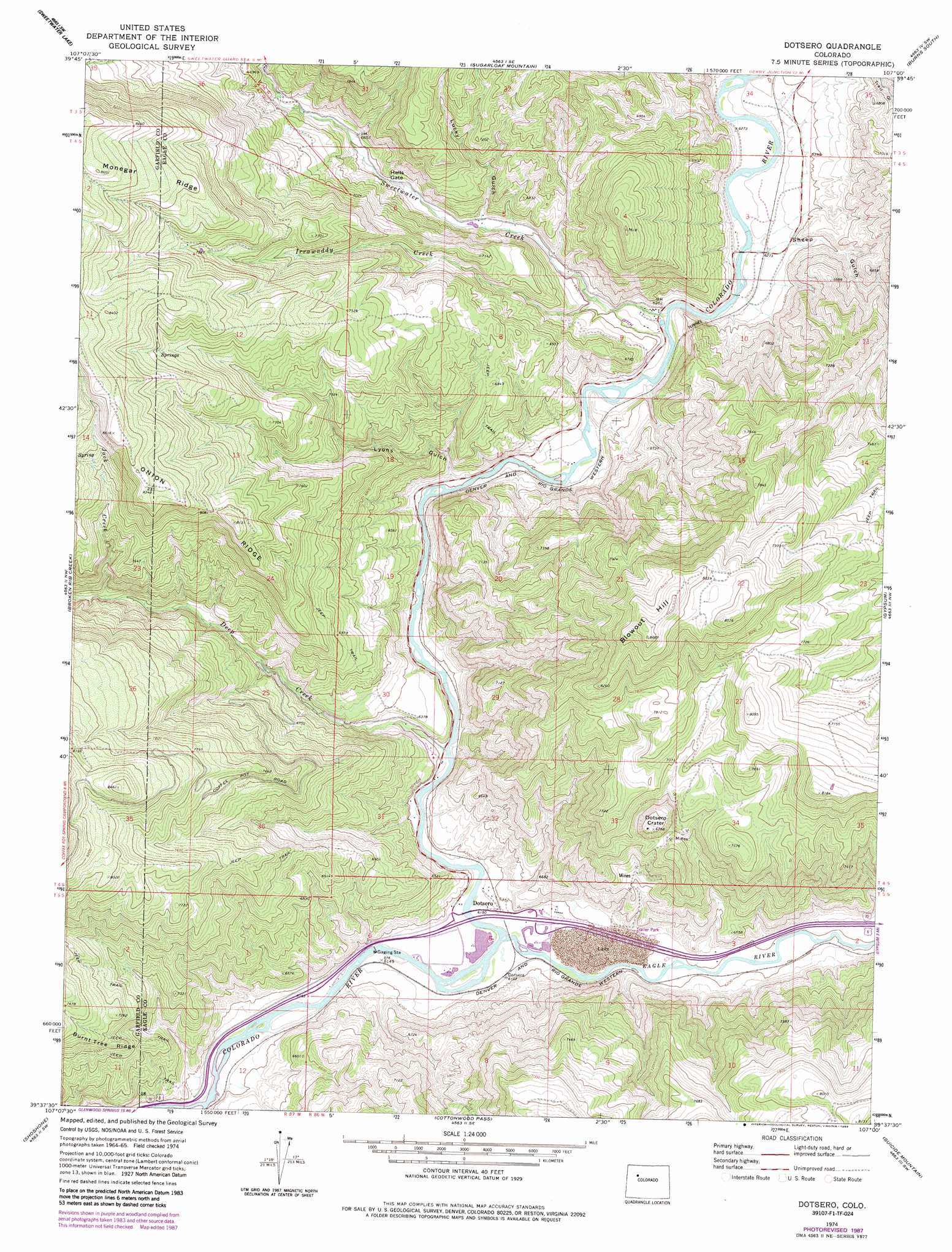
USGS Topo Quad 39107f1 - 1:24,000 scale
| Topo Map Name: | Dotsero |
| USGS Topo Quad ID: | 39107f1 |
| Print Size: | ca. 21 1/4" wide x 27" high |
| Southeast Coordinates: | 39.625° N latitude / 107° W longitude |
| Map Center Coordinates: | 39.6875° N latitude / 107.0625° W longitude |
| U.S. State: | CO |
| Filename: | o39107f1.jpg |
| Download Map JPG Image: | Dotsero topo map 1:24,000 scale |
| Map Type: | Topographic |
| Topo Series: | 7.5´ |
| Map Scale: | 1:24,000 |
| Source of Map Images: | United States Geological Survey (USGS) |
| Alternate Map Versions: |
Dotsero CO 1974, updated 1977 Download PDF Buy paper map Dotsero CO 1974, updated 1977 Download PDF Buy paper map Dotsero CO 1974, updated 1988 Download PDF Buy paper map Dotsero CO 2010 Download PDF Buy paper map Dotsero CO 2013 Download PDF Buy paper map Dotsero CO 2016 Download PDF Buy paper map |
1:24,000 Topo Quads surrounding Dotsero
Big Marvine Peak |
Trappers Lake |
Dome Peak |
Burns North |
Blue Hill |
Deep Lake |
Sweetwater Lake |
Sugarloaf Mountain |
Burns South |
Castle Peak |
Carbonate |
Broken Rib Creek |
Dotsero |
Gypsum |
Eagle |
Glenwood Springs |
Shoshone |
Cottonwood Pass |
Suicide Mountain |
The Seven Hermits |
Cattle Creek |
Carbondale |
Leon |
Toner Reservoir |
Red Creek |
> Back to 39107e1 at 1:100,000 scale
> Back to 39106a1 at 1:250,000 scale
> Back to U.S. Topo Maps home
Dotsero topo map: Gazetteer
Dotsero: Cliffs
Hells Gate elevation 2050m 6725′Dotsero: Craters
Dotsero Crater elevation 2086m 6843′Dotsero: Lakes
Hooper Lake elevation 2476m 8123′Dotsero: Mines
Avon Pit elevation 2036m 6679′Blowout Hill Mine elevation 2164m 7099′
Deep Creek Mine elevation 2468m 8097′
Dotsero Quarry elevation 1875m 6151′
Dotsero: Populated Places
Dotsero elevation 1876m 6154′Dotsero: Ridges
Onion Ridge elevation 2478m 8129′Dotsero: Springs
Dotsero Warm Springs elevation 1905m 6250′Jack Spring elevation 2388m 7834′
Dotsero: Streams
Cottonwood Creek elevation 1866m 6122′Deep Creek elevation 1878m 6161′
Eagle River elevation 1866m 6122′
Irrawaddy Creek elevation 1922m 6305′
Jack Creek elevation 2094m 6870′
Sweetwater Creek elevation 1895m 6217′
Dotsero: Summits
Blowout Hill elevation 2643m 8671′Dotsero: Valleys
Lucky Gulch elevation 1984m 6509′Lyons Gulch elevation 1900m 6233′
Sheep Gulch elevation 1926m 6318′
Dotsero digital topo map on disk
Buy this Dotsero topo map showing relief, roads, GPS coordinates and other geographical features, as a high-resolution digital map file on DVD: