Carbondale Topo Map Colorado
To zoom in, hover over the map of Carbondale
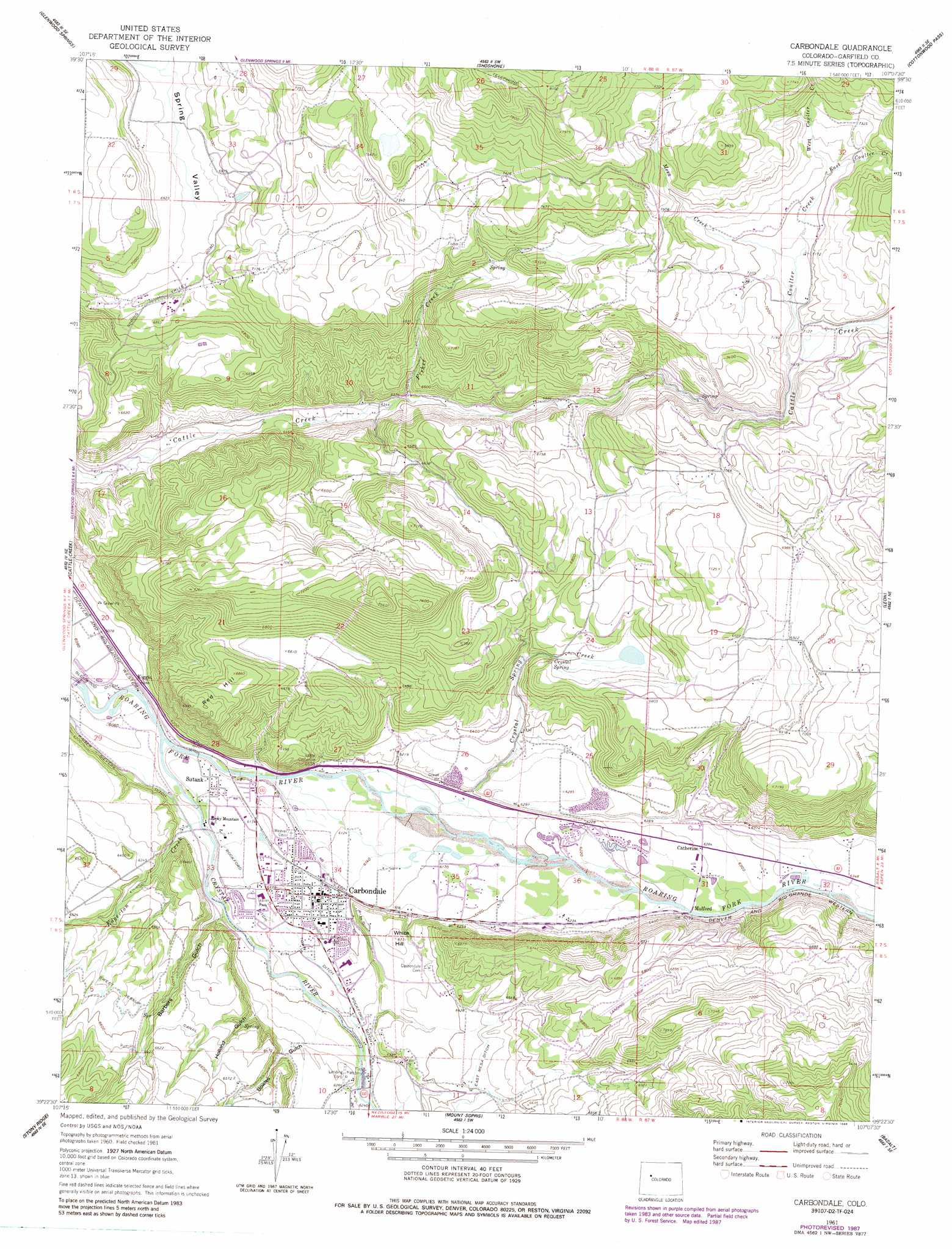
USGS Topo Quad 39107d2 - 1:24,000 scale
| Topo Map Name: | Carbondale |
| USGS Topo Quad ID: | 39107d2 |
| Print Size: | ca. 21 1/4" wide x 27" high |
| Southeast Coordinates: | 39.375° N latitude / 107.125° W longitude |
| Map Center Coordinates: | 39.4375° N latitude / 107.1875° W longitude |
| U.S. State: | CO |
| Filename: | o39107d2.jpg |
| Download Map JPG Image: | Carbondale topo map 1:24,000 scale |
| Map Type: | Topographic |
| Topo Series: | 7.5´ |
| Map Scale: | 1:24,000 |
| Source of Map Images: | United States Geological Survey (USGS) |
| Alternate Map Versions: |
Carbondale CO 1961, updated 1963 Download PDF Buy paper map Carbondale CO 1961, updated 1963 Download PDF Buy paper map Carbondale CO 1961, updated 1966 Download PDF Buy paper map Carbondale CO 1961, updated 1966 Download PDF Buy paper map Carbondale CO 1961, updated 1978 Download PDF Buy paper map Carbondale CO 1961, updated 1984 Download PDF Buy paper map Carbondale CO 1961, updated 1988 Download PDF Buy paper map Carbondale CO 1961, updated 1988 Download PDF Buy paper map Carbondale CO 2010 Download PDF Buy paper map Carbondale CO 2013 Download PDF Buy paper map Carbondale CO 2016 Download PDF Buy paper map |
| FStopo: | US Forest Service topo Carbondale is available: Download FStopo PDF Download FStopo TIF |
1:24,000 Topo Quads surrounding Carbondale
Adams Lake |
Carbonate |
Broken Rib Creek |
Dotsero |
Gypsum |
Storm King Mountain |
Glenwood Springs |
Shoshone |
Cottonwood Pass |
Suicide Mountain |
Center Mountain |
Cattle Creek |
Carbondale |
Leon |
Toner Reservoir |
Quaker Mesa |
Stony Ridge |
Mount Sopris |
Basalt |
Woody Creek |
Elk Knob |
Placita |
Redstone |
Capitol Peak |
Highland Peak |
> Back to 39107a1 at 1:100,000 scale
> Back to 39106a1 at 1:250,000 scale
> Back to U.S. Topo Maps home
Carbondale topo map: Gazetteer
Carbondale: Airports
Glen-Aspen Airport elevation 2125m 6971′Carbondale: Canals
Atkinson Ditch elevation 2077m 6814′Rockford Ditch elevation 1900m 6233′
Town Ditch elevation 1893m 6210′
Carbondale: Dams
Hawk Ditch Dam elevation 1979m 6492′Van Cleve-Fisher Dam elevation 2279m 7477′
Carbondale: Mines
Midcontinent Limestone Quarry elevation 1925m 6315′Carbondale: Parks
John M Fleet Municipal Pool elevation 1883m 6177′Sopris Park elevation 1885m 6184′
Carbondale: Populated Places
Carbondale elevation 1881m 6171′Catherine elevation 1916m 6286′
Kiggin elevation 1867m 6125′
Mulford elevation 1912m 6272′
Satank elevation 1865m 6118′
Carbondale: Post Offices
Carbondale Post Office elevation 1883m 6177′Carbondale: Reservoirs
Hawk Ditch Reservoir elevation 1979m 6492′Van Cleave-Fisher Reservoir elevation 2279m 7477′
Carbondale: Springs
Crystal Spring elevation 2025m 6643′Carbondale: Streams
Coulter Creek elevation 2156m 7073′Crystal River elevation 1847m 6059′
Crystal Spring Creek elevation 1867m 6125′
East Coulter Creek elevation 2195m 7201′
Edgerton Creek elevation 1858m 6095′
Fisher Creek elevation 1939m 6361′
Mesa Creek elevation 2178m 7145′
West Coulter Creek elevation 2195m 7201′
Carbondale: Summits
Red Hill elevation 2136m 7007′White Hill elevation 1929m 6328′
Carbondale: Valleys
Barbers Gulch elevation 1877m 6158′Bowles Gulch elevation 1902m 6240′
Holland Gulch elevation 1904m 6246′
Spring Valley elevation 2080m 6824′
Carbondale digital topo map on disk
Buy this Carbondale topo map showing relief, roads, GPS coordinates and other geographical features, as a high-resolution digital map file on DVD: