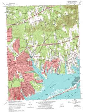
Moriches Topo Map New York
To zoom in, hover over the map of Moriches
USGS Topo Quad 40072g7 - 1:24,000 scale
| Topo Map Name: | Moriches |
| USGS Topo Quad ID: | 40072g7 |
| Print Size: | ca. 21 1/4" wide x 27" high |
| Southeast Coordinates: | 40.75° N latitude / 72.75° W longitude |
| Map Center Coordinates: | 40.8125° N latitude / 72.8125° W longitude |
| U.S. State: | NY |
| Filename: | o40072g7.jpg |
| Download Map JPG Image: | Moriches topo map 1:24,000 scale |
| Map Type: | Topographic |
| Topo Series: | 7.5´ |
| Map Scale: | 1:24,000 |
| Source of Map Images: | United States Geological Survey (USGS) |
| Alternate Map Versions: |
Moriches NY 1957, updated 1958 Download PDF Buy paper map Moriches NY 1967, updated 1970 Download PDF Buy paper map Moriches NY 1967, updated 1970 Download PDF Buy paper map Moriches NY 2010 Download PDF Buy paper map Moriches NY 2013 Download PDF Buy paper map Moriches NY 2016 Download PDF Buy paper map |
1:24,000 Topo Quads surrounding Moriches
Mattituck Hills |
||||
Port Jefferson |
Middle Island |
Wading River |
Riverhead |
Mattituck |
Patchogue |
Bellport |
Moriches |
Eastport |
Quogue |
Sayville |
Howells Point |
Pattersquash Island |
||
> Back to 40072e1 at 1:100,000 scale
> Back to 40072a1 at 1:250,000 scale
> Back to U.S. Topo Maps home
Moriches topo map: Gazetteer
Moriches: Airports
Brookhaven Airport elevation 18m 59′Lufker Airport elevation 15m 49′
Moriches: Bays
Narrow Bay elevation 0m 0′Tuthill Cove elevation 0m 0′
Moriches: Canals
Marks Canal elevation 1m 3′Moriches: Capes
Davids Point elevation 1m 3′Delafield Point elevation 1m 3′
Floyd Point elevation 1m 3′
Forge Point elevation 1m 3′
Island Point elevation 1m 3′
Libby Point elevation 1m 3′
Masury Point elevation 1m 3′
Old Neck elevation 4m 13′
Radio Point elevation 0m 0′
Sands Point elevation 0m 0′
Smiths Point elevation 1m 3′
Tuthill Point elevation 1m 3′
Moriches: Channels
Moriches Inlet elevation 0m 0′Moriches: Crossings
Interchange 58 elevation 15m 49′Interchange 59 elevation 17m 55′
Interchange 69 elevation 15m 49′
Interchange 70 elevation 18m 59′
Moriches: Harbors
The Lagoon elevation 0m 0′Moriches: Islands
New Made Island elevation 1m 3′Moriches: Lakes
Hot Water Pond elevation 24m 78′Moriches: Parks
Smith Point County Park elevation 1m 3′Wertheim National Wildlife Refuge elevation 10m 32′
Moriches: Populated Places
Bellview Beach elevation 1m 3′Center Moriches elevation 8m 26′
East Moriches elevation 9m 29′
Greenwood Village elevation 28m 91′
Manorville elevation 16m 52′
Mastic elevation 9m 29′
Mastic Beach elevation 2m 6′
Moriches elevation 7m 22′
Old Mastic elevation 4m 13′
Shirley elevation 16m 52′
South Manor elevation 15m 49′
Moriches: Post Offices
Center Moriches Post Office elevation 8m 26′Mastic Post Office elevation 12m 39′
Moriches: Reservoirs
East Millpond elevation 3m 9′Mill Pond elevation 3m 9′
West Millpond elevation 2m 6′
Moriches: Streams
Areskonk Creek elevation 0m 0′Ely Creek elevation 0m 0′
Forge River elevation 0m 0′
Home Creek elevation 0m 0′
Lawrence Creek elevation 1m 3′
Lons Creek elevation 1m 3′
Mud Creek elevation 0m 0′
Old Neck Creek elevation 0m 0′
Orchard Neck Creek elevation 0m 0′
Pattersquash Creek elevation 0m 0′
Poospatuck Creek elevation 0m 0′
Second Neck Creek elevation 1m 3′
Senix Creek elevation 0m 0′
Terrell River elevation 0m 0′
Moriches: Summits
Rock Hill elevation 64m 209′Moriches: Swamps
Cranberry Pond elevation 14m 45′Moriches digital topo map on disk
Buy this Moriches topo map showing relief, roads, GPS coordinates and other geographical features, as a high-resolution digital map file on DVD:
Atlantic Coast (NY, NJ, PA, DE, MD, VA, NC)
Buy digital topo maps: Atlantic Coast (NY, NJ, PA, DE, MD, VA, NC)


