Wading River Topo Map New York
To zoom in, hover over the map of Wading River
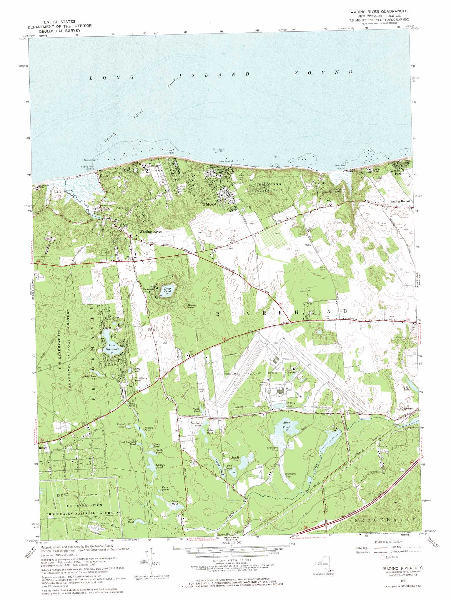
USGS Topo Quad 40072h7 - 1:24,000 scale
| Topo Map Name: | Wading River |
| USGS Topo Quad ID: | 40072h7 |
| Print Size: | ca. 21 1/4" wide x 27" high |
| Southeast Coordinates: | 40.875° N latitude / 72.75° W longitude |
| Map Center Coordinates: | 40.9375° N latitude / 72.8125° W longitude |
| U.S. State: | NY |
| Filename: | o40072h7.jpg |
| Download Map JPG Image: | Wading River topo map 1:24,000 scale |
| Map Type: | Topographic |
| Topo Series: | 7.5´ |
| Map Scale: | 1:24,000 |
| Source of Map Images: | United States Geological Survey (USGS) |
| Alternate Map Versions: |
Wading River NY 1957, updated 1958 Download PDF Buy paper map Wading River NY 1967, updated 1970 Download PDF Buy paper map Wading River NY 2010 Download PDF Buy paper map Wading River NY 2013 Download PDF Buy paper map Wading River NY 2016 Download PDF Buy paper map |
1:24,000 Topo Quads surrounding Wading River
Milford |
Woodmont |
|||
Mattituck Hills |
||||
Port Jefferson |
Middle Island |
Wading River |
Riverhead |
Mattituck |
Patchogue |
Bellport |
Moriches |
Eastport |
Quogue |
Sayville |
Howells Point |
Pattersquash Island |
> Back to 40072e1 at 1:100,000 scale
> Back to 40072a1 at 1:250,000 scale
> Back to U.S. Topo Maps home
Wading River topo map: Gazetteer
Wading River: Airports
Calverton Naval Weapons Industrial Reserve Airport elevation 15m 49′Grumman Peconic River Airport elevation 15m 49′
Wading River: Areas
Pauquaconsuk (historical) elevation 29m 95′Wading River: Bars
Albany Rock elevation 0m 0′Fishing Rock elevation 0m 0′
Herod Point Shoal elevation 0m 0′
Wading River: Basins
Scuttle Hole elevation 13m 42′Wading River: Bays
Long Island Sound elevation 0m 0′Wading River: Capes
Herod Point elevation 1m 3′Wading River: Lakes
Conoe Lake elevation 11m 36′Corey Pond elevation 15m 49′
Cranberry Pond elevation 15m 49′
Deep Pond elevation 8m 26′
Duck Pond elevation 12m 39′
Forest Pond elevation 14m 45′
Fox Pond elevation 12m 39′
Grassy Pond elevation 12m 39′
Horn Pond elevation 15m 49′
Jones Pond elevation 12m 39′
Lake Panamoka elevation 10m 32′
Linus Pond elevation 12m 39′
McKay Lake elevation 12m 39′
North Pond elevation 14m 45′
North Pond elevation 15m 49′
Peasys Pond elevation 15m 49′
Prestons Pond elevation 14m 45′
Round Pond elevation 15m 49′
Sandy Pond elevation 12m 39′
Sandy Pond elevation 12m 39′
Swan Pond elevation 11m 36′
Tarkill Pond elevation 14m 45′
Twin Ponds elevation 12m 39′
Woodchoppers Pond elevation 15m 49′
Zeeks Pond elevation 12m 39′
Wading River: Parks
Babylon Rod and Gun Club Wildlife Preserve elevation 13m 42′Brookhaven State Park elevation 21m 68′
Peconic River County Park elevation 12m 39′
Wildwood State Park elevation 33m 108′
Wading River: Populated Places
Ramblewood Mobile Home Park elevation 26m 85′Thurms Mobile Homes elevation 35m 114′
Wading River elevation 28m 91′
Wildwood elevation 19m 62′
Woodcliff Park elevation 24m 78′
Wading River: Streams
Wading River elevation 1m 3′Wading River digital topo map on disk
Buy this Wading River topo map showing relief, roads, GPS coordinates and other geographical features, as a high-resolution digital map file on DVD:
Atlantic Coast (NY, NJ, PA, DE, MD, VA, NC)
Buy digital topo maps: Atlantic Coast (NY, NJ, PA, DE, MD, VA, NC)
 map DVD")