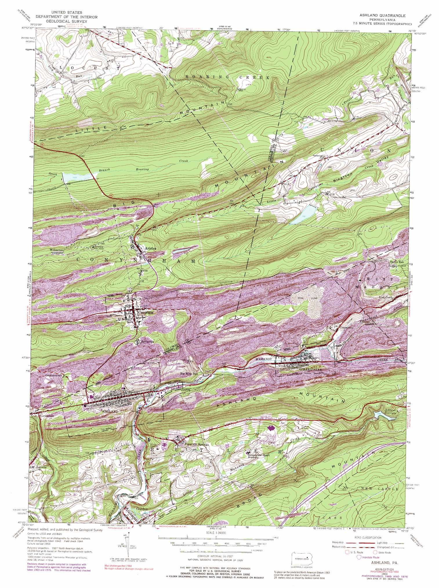
Ashland Topo Map Pennsylvania
To zoom in, hover over the map of Ashland
USGS Topo Quad 40076g3 - 1:24,000 scale
| Topo Map Name: | Ashland |
| USGS Topo Quad ID: | 40076g3 |
| Print Size: | ca. 21 1/4" wide x 27" high |
| Southeast Coordinates: | 40.75° N latitude / 76.25° W longitude |
| Map Center Coordinates: | 40.8125° N latitude / 76.3125° W longitude |
| U.S. State: | PA |
| Filename: | o40076g3.jpg |
| Download Map JPG Image: | Ashland topo map 1:24,000 scale |
| Map Type: | Topographic |
| Topo Series: | 7.5´ |
| Map Scale: | 1:24,000 |
| Source of Map Images: | United States Geological Survey (USGS) |
| Alternate Map Versions: |
Ashland PA 1947 Download PDF Buy paper map Ashland PA 1947 Download PDF Buy paper map Ashland PA 1947, updated 1947 Download PDF Buy paper map Ashland PA 1953, updated 1956 Download PDF Buy paper map Ashland PA 1953, updated 1966 Download PDF Buy paper map Ashland PA 1953, updated 1971 Download PDF Buy paper map Ashland PA 1953, updated 1978 Download PDF Buy paper map Ashland PA 1953, updated 1989 Download PDF Buy paper map Ashland PA 1976, updated 1979 Download PDF Buy paper map Ashland PA 2010 Download PDF Buy paper map Ashland PA 2013 Download PDF Buy paper map Ashland PA 2016 Download PDF Buy paper map |
1:24,000 Topo Quads surrounding Ashland
Millville |
Bloomsburg |
Mifflinville |
Berwick |
Sybertsville |
Danville |
Catawissa |
Shumans |
Nuremberg |
Conyngham |
Shamokin |
Mount Carmel |
Ashland |
Shenandoah |
Delano |
Valley View |
Tremont |
Minersville |
Pottsville |
Orwigsburg |
Tower City |
Pine Grove |
Swatara Hill |
Friedensburg |
Auburn |
> Back to 40076e1 at 1:100,000 scale
> Back to 40076a1 at 1:250,000 scale
> Back to U.S. Topo Maps home
Ashland topo map: Gazetteer
Ashland: Airports
Ashland State General Hospital Heliport elevation 268m 879′Ashland: Dams
Ashland Reservoir Dam elevation 424m 1391′Brush Valley Dam elevation 341m 1118′
Ringtown Dam Number Six elevation 349m 1145′
Ashland: Populated Places
Aristes elevation 523m 1715′Ashland elevation 301m 987′
Big Mine Run elevation 277m 908′
Byrnsville elevation 429m 1407′
Centralia elevation 445m 1459′
Connerton elevation 301m 987′
Fountain Springs elevation 322m 1056′
Germantown elevation 362m 1187′
Girardville elevation 303m 994′
Gordon elevation 260m 853′
Raven Run elevation 465m 1525′
Wilburton elevation 542m 1778′
Wilburton Number Two elevation 543m 1781′
Ashland: Ranges
Little Mountain elevation 543m 1781′Ashland: Reservoirs
Ashland Reservoir elevation 393m 1289′Brush Valley Reservoir elevation 341m 1118′
Ringtown Reservoir Number Six elevation 349m 1145′
Ashland: Streams
Big Mine Run (historical) elevation 280m 918′East Branch Big Mine Run (historical) elevation 401m 1315′
Little Mahanoy Creek elevation 244m 800′
Little Mine Run (historical) elevation 272m 892′
Locust Run (historical) elevation 270m 885′
Rattling Run elevation 249m 816′
Shenandoah Creek elevation 293m 961′
Trexler Run elevation 305m 1000′
Ashland: Summits
Ashland Anticline elevation 390m 1279′Ashland Mountain elevation 530m 1738′
Ashland digital topo map on disk
Buy this Ashland topo map showing relief, roads, GPS coordinates and other geographical features, as a high-resolution digital map file on DVD:
Atlantic Coast (NY, NJ, PA, DE, MD, VA, NC)
Buy digital topo maps: Atlantic Coast (NY, NJ, PA, DE, MD, VA, NC)
 map DVD")