Mount Carmel Topo Map Pennsylvania
To zoom in, hover over the map of Mount Carmel
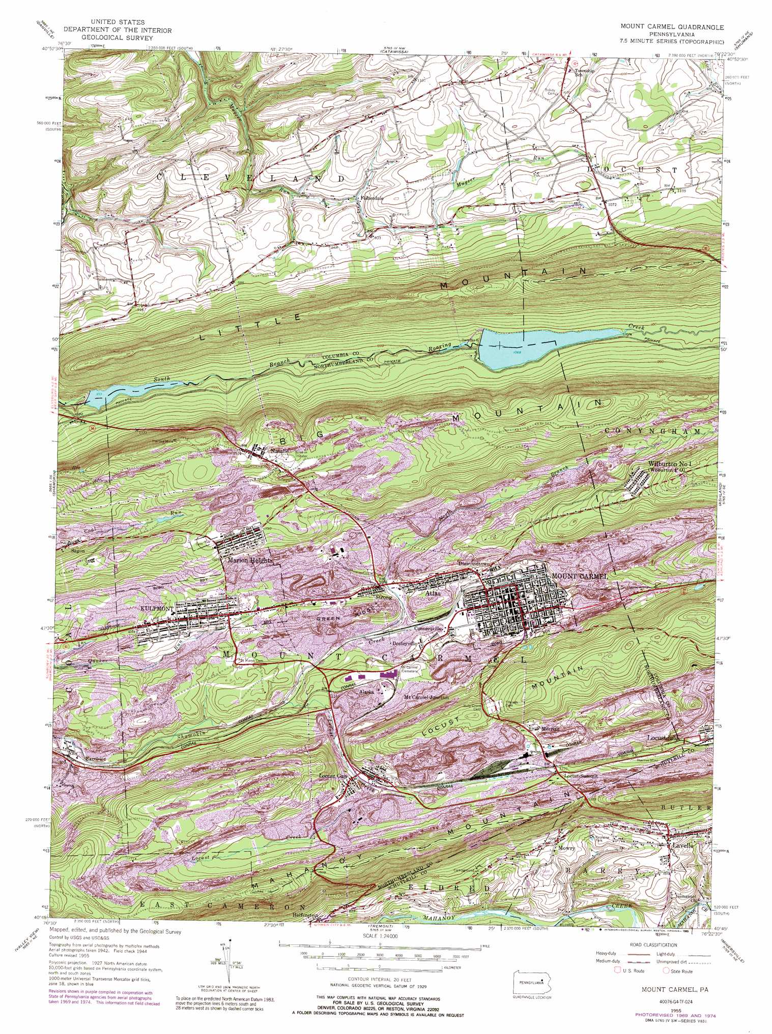
USGS Topo Quad 40076g4 - 1:24,000 scale
| Topo Map Name: | Mount Carmel |
| USGS Topo Quad ID: | 40076g4 |
| Print Size: | ca. 21 1/4" wide x 27" high |
| Southeast Coordinates: | 40.75° N latitude / 76.375° W longitude |
| Map Center Coordinates: | 40.8125° N latitude / 76.4375° W longitude |
| U.S. State: | PA |
| Filename: | o40076g4.jpg |
| Download Map JPG Image: | Mount Carmel topo map 1:24,000 scale |
| Map Type: | Topographic |
| Topo Series: | 7.5´ |
| Map Scale: | 1:24,000 |
| Source of Map Images: | United States Geological Survey (USGS) |
| Alternate Map Versions: |
Mt. Carmel PA 1947 Download PDF Buy paper map Mt. Carmel PA 1947 Download PDF Buy paper map Mount Carmel PA 1955, updated 1956 Download PDF Buy paper map Mount Carmel PA 1955, updated 1961 Download PDF Buy paper map Mount Carmel PA 1955, updated 1971 Download PDF Buy paper map Mount Carmel PA 1955, updated 1978 Download PDF Buy paper map Mount Carmel PA 1955, updated 1989 Download PDF Buy paper map Mount Carmel PA 1977, updated 1979 Download PDF Buy paper map Mount Carmel PA 2010 Download PDF Buy paper map Mount Carmel PA 2013 Download PDF Buy paper map Mount Carmel PA 2016 Download PDF Buy paper map |
1:24,000 Topo Quads surrounding Mount Carmel
Washingtonville |
Millville |
Bloomsburg |
Mifflinville |
Berwick |
Riverside |
Danville |
Catawissa |
Shumans |
Nuremberg |
Trevorton |
Shamokin |
Mount Carmel |
Ashland |
Shenandoah |
Klingerstown |
Valley View |
Tremont |
Minersville |
Pottsville |
Lykens |
Tower City |
Pine Grove |
Swatara Hill |
Friedensburg |
> Back to 40076e1 at 1:100,000 scale
> Back to 40076a1 at 1:250,000 scale
> Back to U.S. Topo Maps home
Mount Carmel topo map: Gazetteer
Mount Carmel: Airports
Numidia Airport elevation 316m 1036′Mount Carmel: Dams
Bear Gap Number Six Dam elevation 325m 1066′Bear Gap Number Two Dam elevation 305m 1000′
Dam Number Five elevation 316m 1036′
Locust Summit Fines Plant Dam elevation 381m 1250′
Storage Reservoir Number Two Dam elevation 379m 1243′
Mount Carmel: Parks
Paradise Park elevation 270m 885′Mount Carmel: Populated Places
Alaska elevation 343m 1125′Atlas elevation 344m 1128′
Beaverdale elevation 323m 1059′
Connersville elevation 321m 1053′
Diamondtown elevation 328m 1076′
Dooleyville elevation 318m 1043′
Excelsior elevation 301m 987′
Fisherdale elevation 262m 859′
Kulpmont elevation 342m 1122′
Lavelle elevation 313m 1026′
Locust Gap elevation 363m 1190′
Locust Summit elevation 383m 1256′
Locustdale elevation 312m 1023′
Marion Heights elevation 418m 1371′
Merrian elevation 404m 1325′
Mount Carmel elevation 336m 1102′
Mount Carmel Junction elevation 347m 1138′
Mowry elevation 306m 1003′
Natalie elevation 467m 1532′
Sagon elevation 346m 1135′
Shady Acres elevation 343m 1125′
Strong elevation 322m 1056′
Wilburton Number One elevation 464m 1522′
Mount Carmel: Post Offices
Wilburton Post Office elevation 464m 1522′Mount Carmel: Reservoirs
Locust Summit Retention Pond elevation 381m 1250′Shamokin Reservoir elevation 315m 1033′
Shamokin Reservoir elevation 276m 905′
Mount Carmel: Ridges
Green Ridge elevation 353m 1158′Mount Carmel: Streams
Locust Creek elevation 304m 997′North Branch Shamokin Creek elevation 310m 1017′
Weikels Run (historical) elevation 287m 941′
Mount Carmel: Summits
Big Mountain elevation 552m 1811′Mount Carmel digital topo map on disk
Buy this Mount Carmel topo map showing relief, roads, GPS coordinates and other geographical features, as a high-resolution digital map file on DVD:
Atlantic Coast (NY, NJ, PA, DE, MD, VA, NC)
Buy digital topo maps: Atlantic Coast (NY, NJ, PA, DE, MD, VA, NC)
 map DVD")