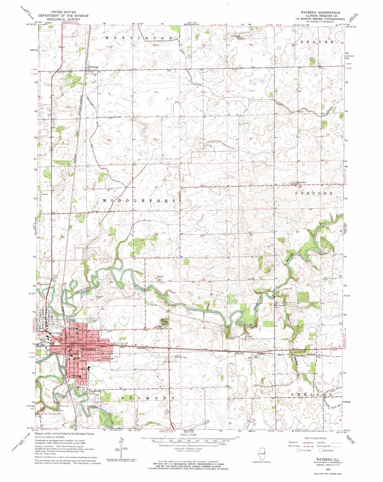
Watseka Topo Map Illinois
To zoom in, hover over the map of Watseka
USGS Topo Quad 40087g6 - 1:24,000 scale
| Topo Map Name: | Watseka |
| USGS Topo Quad ID: | 40087g6 |
| Print Size: | ca. 21 1/4" wide x 27" high |
| Southeast Coordinates: | 40.75° N latitude / 87.625° W longitude |
| Map Center Coordinates: | 40.8125° N latitude / 87.6875° W longitude |
| U.S. State: | IL |
| Filename: | o40087g6.jpg |
| Download Map JPG Image: | Watseka topo map 1:24,000 scale |
| Map Type: | Topographic |
| Topo Series: | 7.5´ |
| Map Scale: | 1:24,000 |
| Source of Map Images: | United States Geological Survey (USGS) |
| Alternate Map Versions: |
Watseka IL 1964, updated 1965 Download PDF Buy paper map Watseka IL 2012 Download PDF Buy paper map Watseka IL 2015 Download PDF Buy paper map |
1:24,000 Topo Quads surrounding Watseka
West Kankakee |
Kankakee |
Saint Anne |
Leesville |
Enos |
Clifton |
L'Erable |
Beaverville |
Donovan |
Morocco |
Gilman |
Crescent |
Watseka |
Sheldon |
Kentland |
Onarga East |
Woodworth |
Milford |
Darrow |
Earl Park |
Cissna Park |
Claytonville |
Wellington |
Stockland |
Boswell |
> Back to 40087e1 at 1:100,000 scale
> Back to 40086a1 at 1:250,000 scale
> Back to U.S. Topo Maps home
Watseka topo map: Gazetteer
Watseka: Airports
Songwood Inn Airport elevation 190m 623′Watseka: Canals
Middleport Ditch Number 1 elevation 191m 626′Watseka: Parks
Bonnies Prairie Nature Preserve elevation 195m 639′Forest Park elevation 193m 633′
Kay Park elevation 193m 633′
Legion Park elevation 190m 623′
Peters Park elevation 192m 629′
Watseka: Populated Places
Eastburn elevation 209m 685′Freedville elevation 196m 643′
Pittwood elevation 196m 643′
Watseka elevation 193m 633′
Watseka: Post Offices
Watseka Post Office elevation 194m 636′Watseka: Valleys
Eastburn Hollow elevation 189m 620′Watseka digital topo map on disk
Buy this Watseka topo map showing relief, roads, GPS coordinates and other geographical features, as a high-resolution digital map file on DVD:
Northern Illinois, Northern Indiana & Southwestern Michigan
Buy digital topo maps: Northern Illinois, Northern Indiana & Southwestern Michigan