Cortland Topo Map Nebraska
To zoom in, hover over the map of Cortland
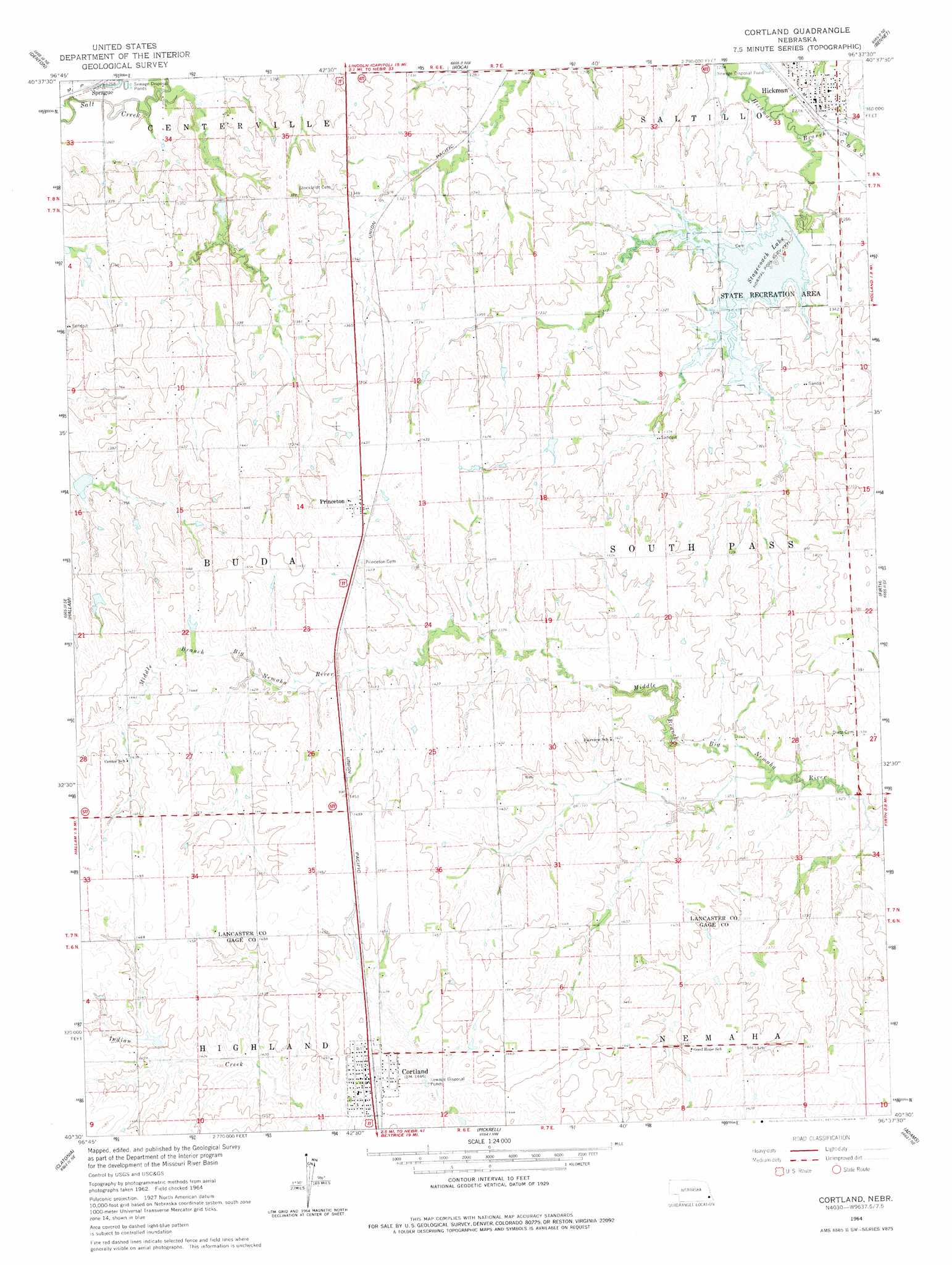
USGS Topo Quad 40096e6 - 1:24,000 scale
| Topo Map Name: | Cortland |
| USGS Topo Quad ID: | 40096e6 |
| Print Size: | ca. 21 1/4" wide x 27" high |
| Southeast Coordinates: | 40.5° N latitude / 96.625° W longitude |
| Map Center Coordinates: | 40.5625° N latitude / 96.6875° W longitude |
| U.S. State: | NE |
| Filename: | O40096e6.jpg |
| Download Map JPG Image: | Cortland topo map 1:24,000 scale |
| Map Type: | Topographic |
| Topo Series: | 7.5´ |
| Map Scale: | 1:24,000 |
| Source of Map Images: | United States Geological Survey (USGS) |
| Alternate Map Versions: |
Cortland NE 1964, updated 1965 Download PDF Buy paper map Cortland NE 1964, updated 1977 Download PDF Buy paper map Cortland NE 2011 Download PDF Buy paper map Cortland NE 2014 Download PDF Buy paper map |
1:24,000 Topo Quads surrounding Cortland
Pleasant Dale |
Emerald |
Lincoln |
Walton |
Eagle |
Crete North |
Denton |
Roca |
Bennet |
Palmyra |
Crete South |
Hallam |
Cortland |
Firth |
Douglas |
Wilber |
Clatonia |
Pickrell |
Adams |
Sterling |
Plymouth |
Beatrice West |
Beatrice East |
Filley |
Crab Orchard |
> Back to 40096e1 at 1:100,000 scale
> Back to 40096a1 at 1:250,000 scale
> Back to U.S. Topo Maps home
Cortland topo map: Gazetteer
Cortland: Airports
Cherry Heliport elevation 431m 1414′Cortland: Dams
Big Nemaha Dam G-18 elevation 415m 1361′Indian Creek Dam 1-A elevation 435m 1427′
Salt Creek Dam 18-9 elevation 413m 1354′
Salt Creek Dam 3-A elevation 393m 1289′
Salt Creek Dam 5-9 elevation 423m 1387′
Stagecoach Dam-Site 9 Dam elevation 389m 1276′
Upper Big Nemaha Dam 13-A elevation 417m 1368′
Upper Big Nemaha Dam 14-C elevation 424m 1391′
Upper Big Nemaha Dam 15-A elevation 424m 1391′
Upper Big Nemaha Dam 15-B elevation 430m 1410′
Upper Big Nemaha Dam 15-D elevation 430m 1410′
Upper Big Nemaha Dam 15-E elevation 429m 1407′
Upper Big Nemaha Dam L-15 elevation 435m 1427′
Upper Salt Creek Dam 2-1 elevation 400m 1312′
Cortland: Parks
Hickman City Park elevation 377m 1236′Olde Towne Park elevation 374m 1227′
Prairie Park elevation 398m 1305′
Stagecoach Lake State Recreation Area elevation 388m 1272′
Cortland: Populated Places
Cortland elevation 440m 1443′Hickman elevation 386m 1266′
Princeton elevation 437m 1433′
Cortland: Post Offices
Cortland Post Office elevation 440m 1443′Hickman Post Office elevation 380m 1246′
Princeton Post Office elevation 437m 1433′
Cortland: Reservoirs
Big Nemaha Reservoir G-18 elevation 415m 1361′Indian Creek Reservoir 1-A elevation 435m 1427′
Reservoir 18-9 elevation 413m 1354′
Salt Creek Reservoir 5-9 elevation 423m 1387′
Stagecoach Lake elevation 391m 1282′
Upper Big Nemaha Reservoir 13-A elevation 417m 1368′
Upper Big Nemaha Reservoir 14-C elevation 424m 1391′
Upper Big Nemaha Reservoir 15-A elevation 424m 1391′
Upper Big Nemaha Reservoir 15-B elevation 430m 1410′
Upper Big Nemaha Reservoir 15-D elevation 430m 1410′
Upper Big Nemaha Reservoir 15-E elevation 429m 1407′
Upper Big Nemaha Reservoir L-15 elevation 435m 1427′
Upper Salt Creek Reservoir 2-1 elevation 400m 1312′
Vergith Reservoir elevation 393m 1289′
Cortland digital topo map on disk
Buy this Cortland topo map showing relief, roads, GPS coordinates and other geographical features, as a high-resolution digital map file on DVD: