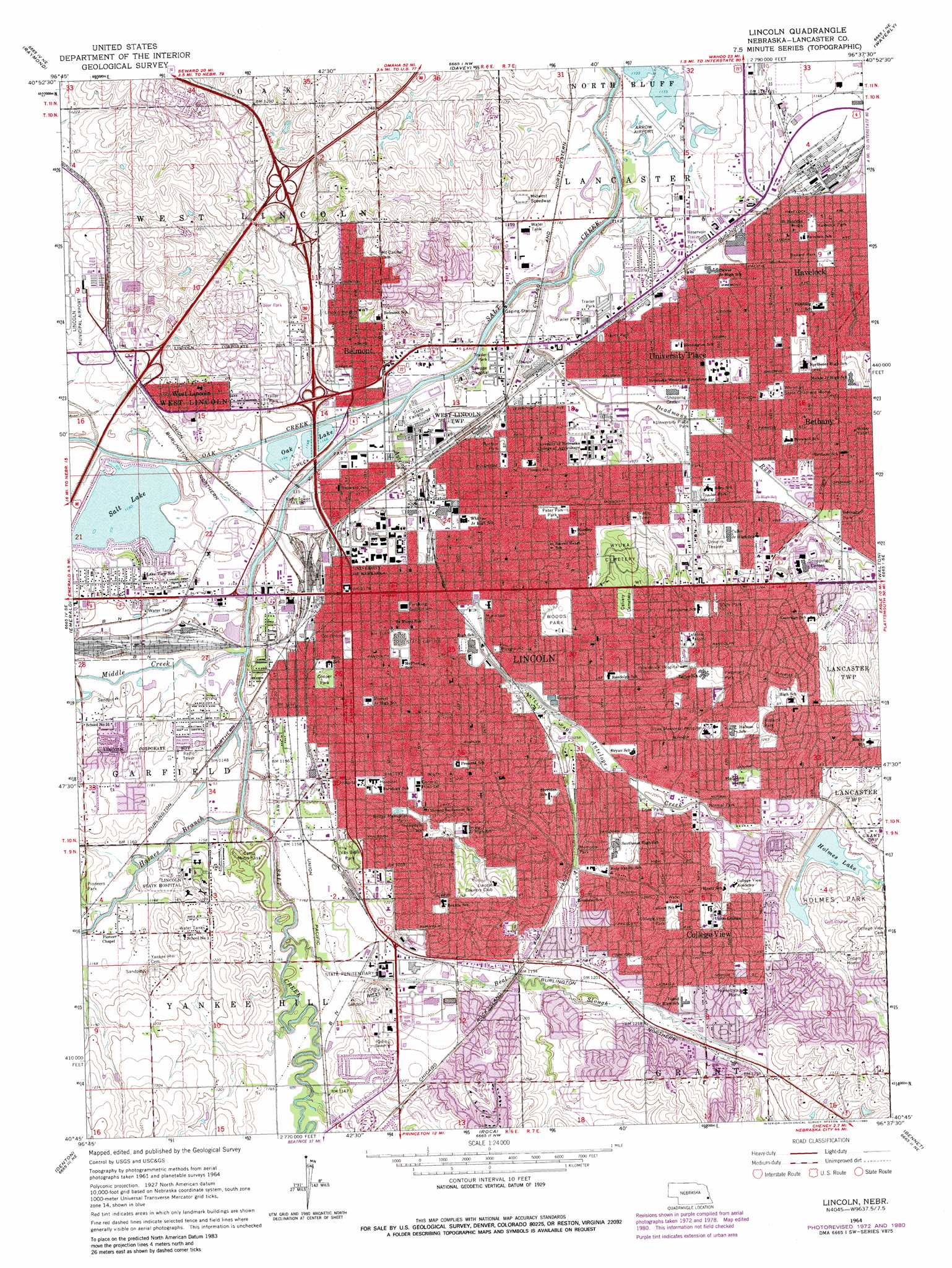
Lincoln Topo Map Nebraska
To zoom in, hover over the map of Lincoln
USGS Topo Quad 40096g6 - 1:24,000 scale
| Topo Map Name: | Lincoln |
| USGS Topo Quad ID: | 40096g6 |
| Print Size: | ca. 21 1/4" wide x 27" high |
| Southeast Coordinates: | 40.75° N latitude / 96.625° W longitude |
| Map Center Coordinates: | 40.8125° N latitude / 96.6875° W longitude |
| U.S. State: | NE |
| Filename: | O40096g6.jpg |
| Download Map JPG Image: | Lincoln topo map 1:24,000 scale |
| Map Type: | Topographic |
| Topo Series: | 7.5´ |
| Map Scale: | 1:24,000 |
| Source of Map Images: | United States Geological Survey (USGS) |
| Alternate Map Versions: |
Lincoln NE 1964, updated 1966 Download PDF Buy paper map Lincoln NE 1964, updated 1973 Download PDF Buy paper map Lincoln NE 1964, updated 1980 Download PDF Buy paper map Lincoln NE 2011 Download PDF Buy paper map Lincoln NE 2014 Download PDF Buy paper map |
1:24,000 Topo Quads surrounding Lincoln
Valparaiso Sw |
Valparaiso |
Ceresco |
Wahoo Se |
Ashland West |
Garland |
Raymond |
Davey |
Waverly |
Greenwood |
Pleasant Dale |
Emerald |
Lincoln |
Walton |
Eagle |
Crete North |
Denton |
Roca |
Bennet |
Palmyra |
Crete South |
Hallam |
Cortland |
Firth |
Douglas |
> Back to 40096e1 at 1:100,000 scale
> Back to 40096a1 at 1:250,000 scale
> Back to U.S. Topo Maps home
Lincoln topo map: Gazetteer
Lincoln: Airports
Bryan Memorial Hospital Heliport elevation 384m 1259′Lincoln General Hospital Heliport elevation 366m 1200′
Saint Elizabeth Community Health Center Heliport elevation 374m 1227′
Lincoln: Crossings
Interchange 1 elevation 363m 1190′Interchange 2 elevation 354m 1161′
Interchange 399 elevation 357m 1171′
Interchange 401 elevation 374m 1227′
Lincoln: Dams
Holmes Lake-Site 17 Dam elevation 377m 1236′Lincoln: Lakes
Salt Lake elevation 348m 1141′Lincoln: Parks
40th and Highway 2 Park elevation 370m 1213′Abbott Sports Complex elevation 348m 1141′
Abel Park elevation 364m 1194′
Abel Stadium elevation 368m 1207′
American Legion Park elevation 356m 1167′
Antelope Park elevation 358m 1174′
Ballard Park elevation 355m 1164′
Belmont Park elevation 362m 1187′
Beltzer Baseball Field and Stadium elevation 351m 1151′
Bethany Park elevation 363m 1190′
Bishop Heights Park elevation 376m 1233′
Boosalis Park elevation 348m 1141′
Breta Park elevation 369m 1210′
Broyhill Fountain elevation 358m 1174′
Centennial Mall elevation 360m 1181′
Coddington and West A Park elevation 356m 1167′
College View Park elevation 384m 1259′
Colonial Hills Park elevation 396m 1299′
Cooper Park elevation 360m 1181′
County-City Building Historical Marker elevation 360m 1181′
Culler Junior High Lot Park elevation 375m 1230′
Doris Baer Complex elevation 350m 1148′
ECCO Park elevation 356m 1167′
Eden Park elevation 367m 1204′
Fairview Historical Marker elevation 384m 1259′
Ferguson House Historical Marker elevation 363m 1190′
Filbert Park elevation 360m 1181′
Fleming Fields elevation 350m 1148′
Folsom Childrens Zoo and Botanical Garden elevation 361m 1184′
Giant Glacial Boulder Historical Marker elevation 368m 1207′
Hartley Neighborhood Park elevation 364m 1194′
Havelock Park elevation 352m 1154′
Hayward Park elevation 349m 1145′
Henry Park elevation 387m 1269′
Highlands Park elevation 378m 1240′
Holmes Park elevation 398m 1305′
Idylwild Park elevation 357m 1171′
Iron Horse Park elevation 352m 1154′
Irvingdale Park elevation 359m 1177′
Lagoon Park elevation 346m 1135′
Lakeview Park elevation 357m 1171′
Larson Park elevation 390m 1279′
Lewis-Syford House Historical Marker elevation 357m 1171′
Lincoln Heights Park elevation 363m 1190′
Lincoln Regional Center Historical Marker elevation 364m 1194′
Lincoln Statue elevation 366m 1200′
Lincolns Founding Block Historical Marker elevation 358m 1174′
Lintel Park elevation 351m 1151′
Maple Lodge Park elevation 374m 1227′
Maxwell Arboretum elevation 356m 1167′
McWilliams Park elevation 357m 1171′
Memorial Park elevation 379m 1243′
Memorial Stadium elevation 354m 1161′
Minipark elevation 374m 1227′
Minipark elevation 356m 1167′
Nebraska Statehood Memorial Historical Marker elevation 363m 1190′
Neighbors Park elevation 358m 1174′
Nevin Park elevation 354m 1161′
Nickerson Field elevation 366m 1200′
Normal Park elevation 366m 1200′
North Bottoms Historical Marker elevation 350m 1148′
Oak Creek Park elevation 345m 1131′
Pansing Park elevation 369m 1210′
Peach Park elevation 362m 1187′
Pentzer Park elevation 351m 1151′
Pershing Rifles Historical Marker elevation 354m 1161′
Peter Pan Park elevation 360m 1181′
Peterson Park elevation 362m 1187′
Piedmont Park elevation 390m 1279′
Pocras Park elevation 369m 1210′
Roberts Park elevation 384m 1259′
Roose Park elevation 367m 1204′
Roper Park elevation 358m 1174′
Rudge Memorial Park elevation 359m 1177′
Sawyer Snell Park elevation 351m 1151′
Schwartzkopf Park elevation 348m 1141′
Sconyers Tennis Courts elevation 366m 1200′
Sculpture Gardens elevation 360m 1181′
Seacrest West Park elevation 348m 1141′
Standing Bear Grounds elevation 352m 1154′
Star City Shores Park elevation 379m 1243′
Stuhr Park elevation 378m 1240′
Sunburst Park elevation 383m 1256′
Taylor Park elevation 369m 1210′
Tierra Briarhurst Park elevation 365m 1197′
Tractor Testing Track elevation 356m 1167′
Trago Park elevation 351m 1151′
Tyrell Park elevation 368m 1207′
University of Nebraska Historical Marker elevation 360m 1181′
University Place Park elevation 352m 1154′
UPCO Park elevation 349m 1145′
Van Dorn Park elevation 362m 1187′
Weir Track elevation 352m 1154′
West Lincoln Park elevation 358m 1174′
Wilderness Park elevation 354m 1161′
Willard and Schroeder Park elevation 355m 1164′
Womens Softball Field elevation 351m 1151′
Woods Park elevation 375m 1230′
Woodside Park elevation 349m 1145′
Woody Greeno Track and Field Facility elevation 368m 1207′
YMCA Wright Park elevation 372m 1220′
Lincoln: Populated Places
Belmont elevation 364m 1194′Bethany elevation 373m 1223′
Center Court Mobile Home Park elevation 350m 1148′
College View elevation 397m 1302′
Contempo-Lincoln Mobile Home Park elevation 371m 1217′
Countryside Estates elevation 352m 1154′
Gaslight Village elevation 352m 1154′
Harbour West Mobile Home Park elevation 360m 1181′
Havelock elevation 357m 1171′
Lincoln elevation 366m 1200′
Mark IV Estates elevation 373m 1223′
Pine Acre Mobile Home Park elevation 350m 1148′
Shady Elm Mobile Home Park elevation 373m 1223′
Shamrock Mobile Home Court elevation 348m 1141′
University Place elevation 357m 1171′
West Lincoln elevation 372m 1220′
West O Trailer Park elevation 357m 1171′
Woodlawn Estates elevation 352m 1154′
Yankee Hill (historical) elevation 362m 1187′
Lincoln: Post Offices
Bethany Post Office (historical) elevation 373m 1223′College View Post Office (historical) elevation 402m 1318′
Havelock Post Office elevation 357m 1171′
Hyersville Post Office (historical) elevation 356m 1167′
Lancaster Post Office (historical) elevation 355m 1164′
Lincoln Post Office elevation 352m 1154′
Normal Post Office (historical) elevation 366m 1200′
University Place Post Office (historical) elevation 357m 1171′
West Lincoln Post Office (historical) elevation 372m 1220′
Lincoln: Reservoirs
Holmes Lake elevation 386m 1266′Oak Lake elevation 356m 1167′
Ropers Lake elevation 346m 1135′
Lincoln: Streams
Antelope Creek elevation 342m 1122′Beal Slough elevation 345m 1131′
Deadmans Run elevation 340m 1115′
Haines Branch elevation 345m 1131′
Middle Creek elevation 347m 1138′
Oak Creek elevation 342m 1122′
Lincoln: Trails
Antelope Creek Trail elevation 381m 1250′Antelope Park Trail elevation 363m 1190′
Billy Wolff Bikeway Trail elevation 374m 1227′
Bison Trail elevation 372m 1220′
Briarhurst-Tierra Trail elevation 365m 1197′
Highlands Trail elevation 378m 1240′
Highway Two Trail elevation 368m 1207′
John Dietrich Bikeway Trail elevation 351m 1151′
Max E Roper Park Trail elevation 358m 1174′
MoPac Trail elevation 357m 1171′
Old Cheney Road Trail elevation 372m 1220′
Rock Island Trail elevation 380m 1246′
Salt Creek Trail elevation 351m 1151′
Superior Street Trail elevation 354m 1161′
Wilderness Park Trails elevation 354m 1161′
Wyuka Trail elevation 360m 1181′
Lincoln digital topo map on disk
Buy this Lincoln topo map showing relief, roads, GPS coordinates and other geographical features, as a high-resolution digital map file on DVD: